Fil:AS17-M-0443.jpg
Fuld opløsning (1.012 × 1.012 billedpunkter, filstørrelse: 258 KB, MIME-type: image/jpeg)
|
|
Denne fil er fra Wikimedia Commons. Beskrivelsen af filen fra Commons er gengivet nedenfor. |
Beskrivelse
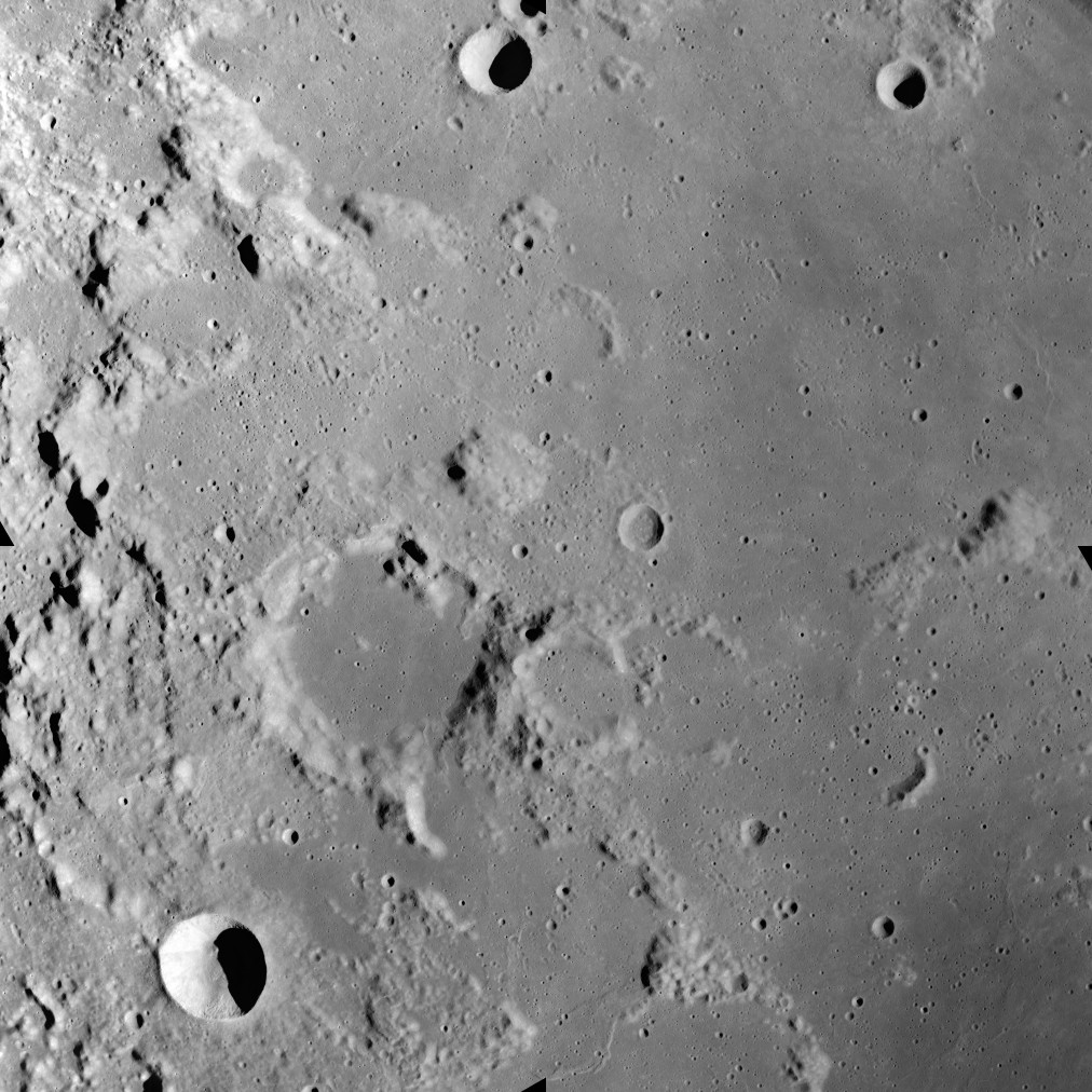
This image was taken during the Apollo 17 mapping metric sequence, revolution #14. The selenographic coordinates of this image are 20° N, 35.90° E.
At the center of this image is the dome-like Mons Maraldi, and just to the southwest is the flooded Maraldi crater. Most of the eastern half of this view is occupied by the Sinus Amoris, a lunar mare, and the flooded remnants of older formations. The bowl-shaped crater in the southwest corner is Gardner, and the cup-shaped crater at top-center is Franck.
This picture was produced by reducing a Hi-res image to 25% of full size, then rotating 90° counter-clockwise so that north is toward the top edge.
Source: Lunar & Planetary Institute, http://www.lpi.usra.edu/resources/apollo/frame/?AS17-M-0443 [1]
Licensering
| Denne fil er i offentligt domæne i USA fordi den udelukkende er skabt af NASA. NASAs ophavsretspolitik erklærer at materiale udgivet af NASA ikke er omfattet af ophavsret medmindre andet er nævnt. (Se også Template:PD-USGov, NASAs ophavsretspolitik eller JPLs politik for brug af billeder.) | ||
 |
Advarsler:
|
Filhistorik
Klik på en dato/tid for at se filen som den så ud på det tidspunkt.
| Dato/tid | Miniaturebillede | Dimensioner | Bruger | Kommentar | |
|---|---|---|---|---|---|
| nuværende | 19. jun. 2018, 22:22 | | 1.012 × 1.012 (258 KB) | Jstuby | higher resolution, better quality, from ASU |
| 27. jan. 2006, 19:58 |  | 601 × 600 (90 KB) | RJHall | Maraldi crater and surroundings from Apollo 17. |
Filanvendelse
Den følgende side bruger denne fil:
Global filanvendelse
Følgende andre wikier anvender denne fil:
- Anvendelser på ca.wikipedia.org
- Anvendelser på ce.wikipedia.org
- Anvendelser på de.wikipedia.org
- Anvendelser på en.wikipedia.org
- Anvendelser på es.wikipedia.org
- Anvendelser på fa.wikipedia.org
- Anvendelser på fr.wikipedia.org
- Anvendelser på io.wikipedia.org
- Anvendelser på it.wikipedia.org
- Anvendelser på lb.wikipedia.org
- Anvendelser på pl.wikipedia.org
- Anvendelser på ru.wikipedia.org
- Anvendelser på sv.wikipedia.org
- Anvendelser på tt.wikipedia.org
- Anvendelser på www.wikidata.org
- Anvendelser på zh.wikipedia.org