Fil:British Empire.png
Størrelse af denne forhåndsvisning: 800 × 351 pixels. Andre opløsninger: 320 × 140 pixels | 640 × 281 pixels | 1.425 × 625 pixels.
Fuld opløsning (1.425 × 625 billedpunkter, filstørrelse: 41 KB, MIME-type: image/png)
|
|
Denne fil er fra Wikimedia Commons. Beskrivelsen af filen fra Commons er gengivet nedenfor. |
Beskrivelse
| Beskrivelse |
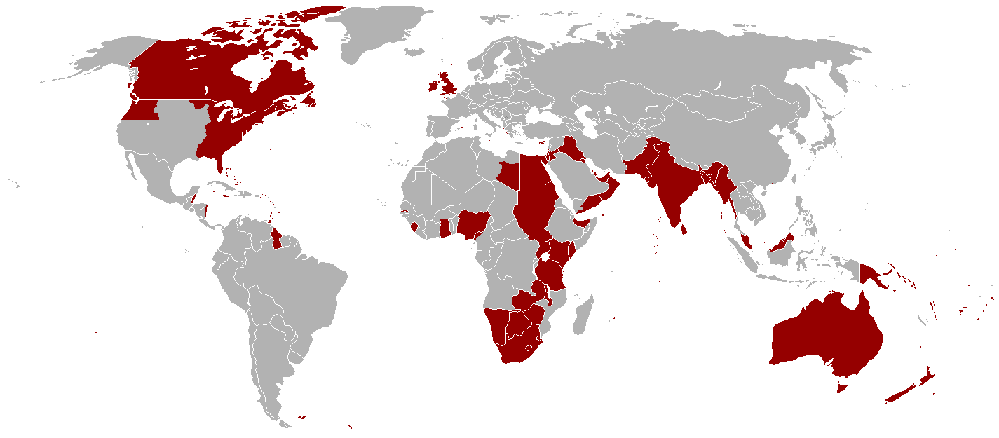
English: Map of all the offical territorial claims of the British Empire that it ever held. (Do keep in mind that Oregon Territory was shared with the United States and south-east Libya was shared with Italy in a disputed part of what was then known as Italian North Africa). |
| Dato | 2. januar 2005 (original upload date) |
| Kilde | Information gathered throughout the English Wikipedia |
| Forfatter | Ramirez72, Andersmusician, Vadac |
| Tilladelse (Genbrug af denne fil) |
Released into the public domain (by the author). |
Licensering
Denne fil er udgivet under Creative Commons Navngivelse – Del på samme vilkår 2.5 Generisk-licensen
- Du må frit:
- at dele – at kopiere, distribuere og overføre værket
- at remixe – at tilpasse værket
- Under følgende vilkår:
- kreditering – Du skal give passende kreditering, angive et link til licensen, og oplyse om der er foretaget ændringer. Du må gøre det på enhver fornuftig måde, men ikke på en måde der antyder at licensgiveren godkender dig eller din anvendelse.
- deling på samme vilkår – Hvis du bearbejder, ændrer eller bygger videre på dette værk, skal du distribuere dine bidrag under den samme eller en kompatibel licens som originalen.
Filhistorik
Klik på en dato/tid for at se filen som den så ud på det tidspunkt.
| Dato/tid | Miniaturebillede | Dimensioner | Bruger | Kommentar | |
|---|---|---|---|---|---|
| nuværende | 31. okt. 2021, 10:16 | | 1.425 × 625 (41 KB) | Randomastwritter | jubaland |
| 14. dec. 2010, 03:16 |  | 1.425 × 625 (51 KB) | Vadac | Clearer version which includes a huge amount of missing territory in the western region of British America which was part of the British Empire from 1763-1783. | |
| 2. jan. 2005, 03:05 |  | 1.357 × 628 (24 KB) | Nickshanks | Territories once under administration from London. Excludes parts of France (not sure what to include), British Antarctic Territories, and many small Pacific and Indian Ocean islands. {{PD}} |
Filanvendelse
De følgende 3 sider bruger denne fil:
Global filanvendelse
Følgende andre wikier anvender denne fil:
- Anvendelser på en.wikipedia.org
- Anvendelser på he.wikipedia.org
- Anvendelser på nn.wikipedia.org
- Anvendelser på no.wikipedia.org