Fil:Cayman Islands location map.svg

Size of this PNG preview of this SVG file: 799 × 319 pixels. Andre opløsninger: 320 × 128 pixels | 640 × 256 pixels | 1.024 × 409 pixels | 1.280 × 511 pixels | 2.560 × 1.022 pixels | 924 × 369 pixels.
Fuld opløsning (SVG fil, basisstørrelse 924 × 369 pixels, filstørrelse: 33 KB)
|
|
Denne fil er fra Wikimedia Commons. Beskrivelsen af filen fra Commons er gengivet nedenfor. |
| Beskrivelse |
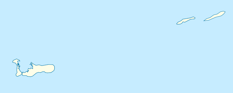
Deutsch: Positionskarte der Kaimaninseln. Geographische Begrenzungen der Karte:
English: Location map of the Cayman Islands. Geographic limits of the map:
|
| Dato | |
| Kilde | Eget arbejde, using OpenStreetMap Data for the coastlines |
| Forfatter |
Graphic made by Carport |
Licensering
Denne fil er udgivet under Creative Commons Navngivelse – Del på samme vilkår 2.0 Generisk-licensen.
- Du må frit:
- at dele – at kopiere, distribuere og overføre værket
- at remixe – at tilpasse værket
- Under følgende vilkår:
- kreditering – Du skal give passende kreditering, angive et link til licensen, og oplyse om der er foretaget ændringer. Du må gøre det på enhver fornuftig måde, men ikke på en måde der antyder at licensgiveren godkender dig eller din anvendelse.
- deling på samme vilkår – Hvis du bearbejder, ændrer eller bygger videre på dette værk, skal du distribuere dine bidrag under den samme eller en kompatibel licens som originalen.
Filhistorik
Klik på en dato/tid for at se filen som den så ud på det tidspunkt.
| Dato/tid | Miniaturebillede | Dimensioner | Bruger | Kommentar | |
|---|---|---|---|---|---|
| nuværende | 23. nov. 2009, 19:07 | 924 × 369 (33 KB) | Carport | {{Information |Description={{de|1=Positionskarte der {{w|Kaimaninseln|3=de}}. Geographische Begrenzungen der Karte: * N: 19.84° N * S: 19.14° N * W: 81.52° W * E: 79.66° W}} {{en|1=Location map of the {{w|Cayman Islands}}. Geographic limits of the ma |
Filanvendelse
De følgende 2 sider bruger denne fil:
Global filanvendelse
Følgende andre wikier anvender denne fil:
- Anvendelser på af.wikipedia.org
- Anvendelser på an.wikipedia.org
- Anvendelser på ar.wikipedia.org
- Anvendelser på ast.wikipedia.org
- Anvendelser på ba.wikipedia.org
- Anvendelser på be.wikipedia.org
- Anvendelser på bg.wikipedia.org
- Anvendelser på ceb.wikipedia.org
- Plantilya:Location map United Kingdom Cayman Islands
- Welch Point
- South Channel
- Palmetto Point
- The Narrows
- Crawl Bay
- Sandy Point
- East Point
- West Bay
- Long Point
- Low Point
- South West Point
- George Town
- Charles Bay
- West End Point
- West End
- Water Cay
- Southwest Point
- Gun Bluff
- Cedar Point
- The Bight
- North Side
- East End
- Eden Rocks
- Prospect Point
- Stake Bay
- Little Sound
- Main Channel
- Rum Point
- Sand Cay
- East Channel
- North Reef
- Boatswain Point
- Beach Point
- Owen Island
Vis flere globale anvendelser af denne fil.