Fil:ElectoralCollege1980-Large.png

Størrelse af denne forhåndsvisning: 800 × 430 pixels. Andre opløsninger: 320 × 172 pixels | 640 × 344 pixels | 1.182 × 635 pixels.
Fuld opløsning (1.182 × 635 billedpunkter, filstørrelse: 166 KB, MIME-type: image/png)
|
|
Denne fil er fra Wikimedia Commons. Beskrivelsen af filen fra Commons er gengivet nedenfor. |
| U.S. presidential election maps from the National Atlas of the United States |
| See also: SVG maps |
| 1789 · 1792 · 1796 · 1800 · 1804 · 1808 · 1812 · 1816 · 1820 · 1824 · 1828 · 1832 · 1836 · 1840 · 1844 · 1848 · 1852 · 1856 · 1860 · 1864 · 1868 · 1872 · 1876 · 1880 · 1884 · 1888 · 1892 · 1896 · 1900 · 1904 · 1908 · 1912 · 1916 · 1920 · 1924 · 1928 · 1932 · 1936 · 1940 · 1944 · 1948 · 1952 · 1956 · 1960 · 1964 · 1968 · 1972 · 1976 · 1980 · 1984 · 1988 · 1992 · 1996 · 2000 · 2004 |
Beskrivelse
| Beskrivelse |
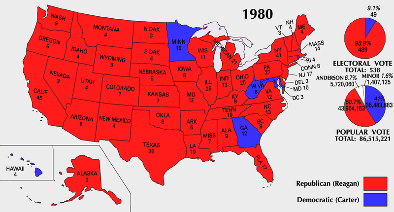
English: 1980 Electoral College Map |
| Kilde | https://nationalmap.gov/small_scale/printable/elections.html |
| Forfatter | United States Geological Survey |
|

|
Dette billede (eller alle billederne i denne artikel eller kategori) bør genskabes ved hjælp af vektorgrafik som en SVG-fil. Dette har flere fordele; se Commons:Media for cleanup for mere information. Hvis der eksisterer en SVG-version af dette billede, så vær venlig at lægge den op. Efter en SVG-version er blevet lagt op, så erstat denne skabelon med {{Vector version available|nyt billedes navn.svg}} på denne side.
|
Licensering
This map was obtained from an edition of the National Atlas of the United States. Like almost all works of the U.S. federal government, works from the National Atlas are in the public domain in the United States.
Online access: NationalAtlas.gov | 1970 print edition: Library of Congress, Perry-Castañeda Library
|
Filhistorik
Klik på en dato/tid for at se filen som den så ud på det tidspunkt.
| Dato/tid | Miniaturebillede | Dimensioner | Bruger | Kommentar | |
|---|---|---|---|---|---|
| nuværende | 25. jul. 2007, 12:18 | | 1.182 × 635 (166 KB) | Cardsplayer4life~commonswiki | Reverted to earlier revision |
| 25. jul. 2007, 11:34 |  | 1.182 × 635 (107 KB) | Joseph Solis in Australia~commonswiki | {{PD-USGov-Atlas}} Category:1980 {{US presidential election maps}} | |
| 9. jul. 2007, 03:44 |  | 1.182 × 635 (166 KB) | Cardsplayer4life~commonswiki | {{PD-USGov-Atlas}} {{US presidential election maps}} | |
| 6. jul. 2007, 11:38 |  | 1.182 × 635 (107 KB) | Joseph Solis in Australia~commonswiki | {{PD-USGov-Atlas}} Category:1980 {{US presidential election maps}} | |
| 2. jul. 2007, 04:28 |  | 1.182 × 635 (166 KB) | Cardsplayer4life~commonswiki | {{PD-USGov-Atlas}} {{US presidential election maps}} | |
| 29. jun. 2007, 12:16 |  | 1.182 × 635 (107 KB) | Joseph Solis in Australia~commonswiki | {{PD-USGov-Atlas}} Category:1980 {{US presidential election maps}} | |
| 21. jun. 2007, 23:07 |  | 1.182 × 635 (166 KB) | Cardsplayer4life~commonswiki | {{PD-USGov-Atlas}} Category:1980 {{US presidential election maps}} | |
| 31. maj 2007, 10:31 |  | 1.182 × 635 (107 KB) | Joseph Solis in Australia~commonswiki | {{PD-USGov-Atlas}} {{US presidential election maps}} | |
| 25. maj 2006, 22:05 |  | 1.182 × 635 (94 KB) | JP06035 | switched colors | |
| 22. jan. 2006, 18:08 |  | 1.182 × 635 (107 KB) | Red devil 666 | {{PD-USGov-Atlas}} |
Filanvendelse
Den følgende side bruger denne fil:
Global filanvendelse
Følgende andre wikier anvender denne fil:
- Anvendelser på cs.wikipedia.org
- Anvendelser på en.wikipedia.org
- Anvendelser på fi.wikipedia.org
- Anvendelser på fr.wikipedia.org
- Anvendelser på hu.wikipedia.org
- Anvendelser på it.wikipedia.org
- Anvendelser på nl.wikipedia.org
- Anvendelser på uk.wikipedia.org
- Anvendelser på vi.wikipedia.org