Fil:GreatBarrierReef-PIA03401.jpg

Fuld opløsning (1.629 × 1.816 billedpunkter, filstørrelse: 404 KB, MIME-type: image/jpeg)
|
|
Denne fil er fra Wikimedia Commons. Beskrivelsen af filen fra Commons er gengivet nedenfor. |
- Source: http://photojournal.jpl.nasa.gov/catalog/pia03401 (original name: PIA03401.jpg), also available as TIFF
- Taken by: MISR instrument on August 26, 2000 (Terra orbit 3679)
- Image Credit: NASA/GSFC/LaRC/JPL, MISR Team
See also: Image:GreatBarrierReef-EO.JPG, a rectangular part of this image.
| Denne fil er i offentligt domæne i USA fordi den udelukkende er skabt af NASA. NASAs ophavsretspolitik erklærer at materiale udgivet af NASA ikke er omfattet af ophavsret medmindre andet er nævnt. (Se også Template:PD-USGov, NASAs ophavsretspolitik eller JPLs politik for brug af billeder.) | ||
 |
Advarsler:
|
Original Caption Released with Image
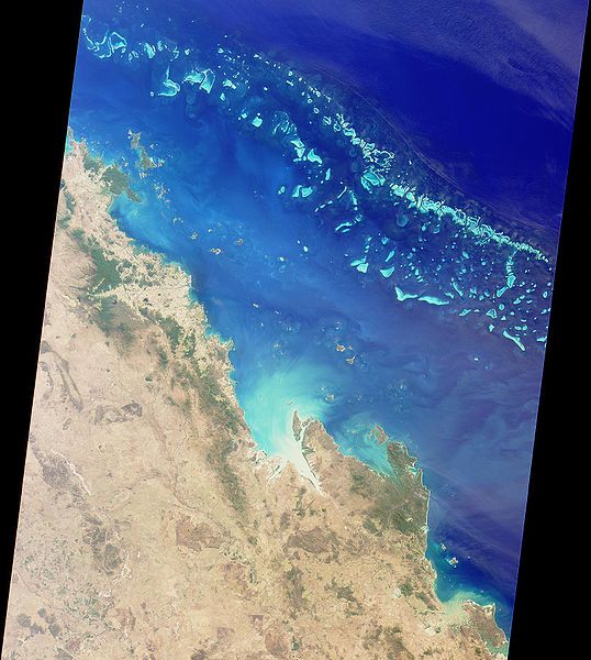
The Great Barrier Reef extends for 2,000 kilometers along the northeastern coast of Australia. It is not a single reef, but a vast maze of reefs, passages, and coral cays (islands that are part of the reef). This nadir true-color image was acquired by the MISR instrument on August 26, 2000 (Terra orbit 3679), and shows part of the southern portion of the reef adjacent to the central Queensland coast. The width of the MISR swath is approximately 380 kilometers, with the reef clearly visible up to approximately 200 kilometers from the coast. It may be difficult to see the myriad details in the browse image, but if you retrieve the higher resolution version, a zoomed display reveals the spectacular structure of the many reefs.
The more northerly coastal area in this image shows the vast extent of sugar cane cultivation, this being the largest sugar producing area in Australia, centered on the city of Mackay. Other industries in the area include coal, cattle, dairying, timber, grain, seafood, and fruit. The large island off the most northerly part of the coast visible in this image is Whitsunday Island, with smaller islands and reefs extending southeast, parallel to the coast. These include some of the better known resort islands such as Hayman Island, Lindeman, Hamilton, and Brampton Islands.
Further south, just inland of the small semicircular bay near the right of the image, is Rockhampton, the largest city along the central Queensland coast, and the regional center for much of central Queensland. Rockhampton is just north of the Tropic of Capricorn. Its hinterland is a rich pastoral, agricultural, and mining region.
MISR was built and is managed by NASA's Jet Propulsion Laboratory, Pasadena, CA, for NASA's Office of Earth Science, Washington, DC. The Terra satellite is managed by NASA's Goddard Space Flight Center, Greenbelt, MD. JPL is a division of the California Institute of Technology.
List of images provided by user Duesentrieb (This link helps me to find all my images) -- Duesentrieb
Filhistorik
Klik på en dato/tid for at se filen som den så ud på det tidspunkt.
| Dato/tid | Miniaturebillede | Dimensioner | Bruger | Kommentar | |
|---|---|---|---|---|---|
| nuværende | 23. maj 2005, 16:34 | | 1.629 × 1.816 (404 KB) | Duesentrieb | Great Barrier Reef, Australia * '''Source:''' photojournal.jpl.nasa.gov/catalog/pia03401 (original name: PIA03401.jpg), also available as TIFF * '''Taken by:''' MISR instrument on August 26, 2000 (Terra orbit 3679) * '''Image Credit:''' NASA/GSF |
Filanvendelse
Den følgende side bruger denne fil: