Fil:Languages of CE Europe-3.PNG
Størrelse af denne forhåndsvisning: 524 × 599 pixels. Andre opløsninger: 210 × 240 pixels | 419 × 480 pixels | 951 × 1.088 pixels.
Fuld opløsning (951 × 1.088 billedpunkter, filstørrelse: 769 KB, MIME-type: image/png)
|
|
Denne fil er fra Wikimedia Commons. Beskrivelsen af filen fra Commons er gengivet nedenfor. |
Beskrivelse
| Beskrivelse |
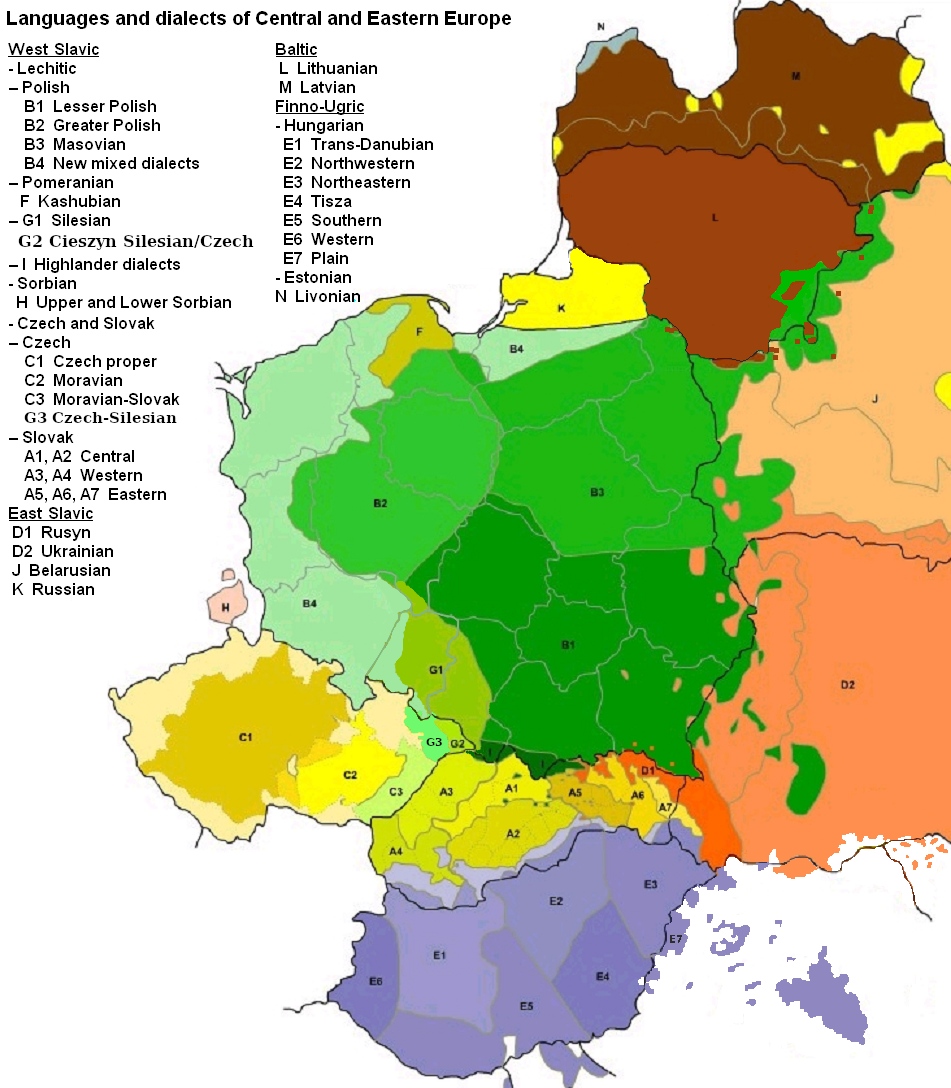
English: Map of languages and dialects of Central and Eastern Europe
Polski: Języki i dialekty Europy Srodkowo-Wschodniej
Deutsch: Legende:
|
||
| Dato | |||
| Kilde |
Eget arbejde |
||
| Forfatter | |||
| Andre versioner |
|
|

|
Dette billede (eller alle billederne i denne artikel eller kategori) bør genskabes ved hjælp af vektorgrafik som en SVG-fil. Dette har flere fordele; se Commons:Media for cleanup for mere information. Hvis der eksisterer en SVG-version af dette billede, så vær venlig at lægge den op. Efter en SVG-version er blevet lagt op, så erstat denne skabelon med {{Vector version available|nyt billedes navn.svg}} på denne side.
|
Licensering

|
Tilladelse er givet til at kopiere, distribuere og/eller ændre dette dokument under betingelserne i GNU Free Documentation License', Version 1.2 eller enhver senere version udgivet af Free Software Foundation; uden et invariant afsnit, ingen forsidetekster, og ingen bagsidetekst. En kopi af licensen er inkluderet i afsnittet GNU Free Documentation License. |
| Denne fil er udgivet under Creative Commons Kreditering-Del på samme vilkår 3.0 Ikke-porteret-licensen. | ||
| Kreditering: Zaragoza, Kpalion, Dellijks | ||
| ||
| Denne licens blev tilføjet som en del af GFDL-licensopdateringen. |
Oprindelig oplægningslog
This image is a derivative work of the following images:
- File:Languages_of_CE_Europe.PNG licensed with GFDL
- 2008-08-25T20:42:18Z Kpalion 951x1088 (1053557 Bytes) {{Information |Description={{en|Map of languages and dialects of Central and Eastern Europe}} |Source=*[[:Image:Jezyki_i_dialekty_Europa_Srodkowo_Wsch..jpg|]] |Date=2008-08-25 20:40 (UTC) |Author=*derivative work: ~~~ *[[:Ima
Filhistorik
Klik på en dato/tid for at se filen som den så ud på det tidspunkt.
| Dato/tid | Miniaturebillede | Dimensioner | Bruger | Kommentar | |
|---|---|---|---|---|---|
| nuværende | 17. aug. 2019, 08:47 | | 951 × 1.088 (769 KB) | D T G | G1 - changed western border (compare my other map: File:Gwary śląskie wg Zaręby.png - sources there); G2 - changed name and classification (this was part of the Polish Cieszyn Silesian, after 1920 evolving towards Czech, but it was absurd that it would be classified as Czech when to South-West was just G1, not differentiated from G1 in Poland! I repeat it was absurd!, therefore I created G3, see below); G3 - created Czech-Silesian also know as Lach dialects, up to 1980s regarded by some... |
| 17. aug. 2015, 09:42 |  | 951 × 1.088 (928 KB) | Winnetou14 | Reverted to version as of 19:28, 13 September 2009 | |
| 12. nov. 2009, 01:11 |  | 951 × 1.088 (697 KB) | Alex Tora | {{Information |Description= |Source={{own}} |Date= |Author=Alex Tora |Permission= |other_versions= }} | |
| 13. sep. 2009, 21:28 |  | 951 × 1.088 (928 KB) | Scooter20 | Fixed Hungarian & Ukrainian in Romania, Ukrainian in Moldova and Romanian in Hungary and Ukraine | |
| 20. jul. 2009, 00:16 |  | 951 × 1.088 (982 KB) | Dellijks | {{Information |Description={{en|Map of languages and dialects of Central and Eastern Europe}}{{pl|Języki i dialekty Europy Srodkowo-Wschodniej}} {{de|-> * B1 - Kleinpolnisch * B2 - Großpolnisch * B3 - Masowisch * B4 - Hochpolnisch * F - Kaschubisch * G1 |
Filanvendelse
Den følgende side bruger denne fil:
Global filanvendelse
Følgende andre wikier anvender denne fil:
- Anvendelser på af.wikipedia.org
- Anvendelser på als.wikipedia.org
- Anvendelser på am.wikipedia.org
- Anvendelser på ang.wikipedia.org
- Anvendelser på an.wikipedia.org
- Anvendelser på arz.wikipedia.org
- Anvendelser på ast.wikipedia.org
- Anvendelser på bo.wikipedia.org
- Anvendelser på br.wikipedia.org
- Anvendelser på csb.wikipedia.org
- Anvendelser på cs.wikipedia.org
- Anvendelser på cv.wikipedia.org
- Anvendelser på de.wikipedia.org
- Anvendelser på diq.wikipedia.org
- Anvendelser på el.wikipedia.org
- Anvendelser på en.wikipedia.org
- Anvendelser på en.wiktionary.org
- Anvendelser på eo.wikipedia.org
- Anvendelser på eu.wikipedia.org
- Anvendelser på frr.wikipedia.org
- Anvendelser på fr.wikipedia.org
- Anvendelser på fur.wikipedia.org
- Anvendelser på fy.wikipedia.org
- Anvendelser på gd.wikipedia.org
- Anvendelser på he.wikipedia.org
- Anvendelser på hr.wikipedia.org
- Anvendelser på hsb.wikipedia.org
- Anvendelser på hy.wikipedia.org
- Anvendelser på incubator.wikimedia.org
- Anvendelser på ka.wikipedia.org
- Anvendelser på ko.wikipedia.org
- Anvendelser på la.wikipedia.org
- Anvendelser på mg.wikipedia.org
- Anvendelser på ms.wikipedia.org
- Anvendelser på nl.wikipedia.org
- Anvendelser på pnb.wikipedia.org
Vis flere globale anvendelser af denne fil.