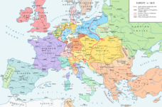
Fil:Map congress of vienna.jpg
Map_congress_of_vienna.jpg (767 × 594 billedpunkter, filstørrelse: 325 KB, MIME-type: image/jpeg)
Filhistorik
Klik på en dato/tid for at se filen som den så ud på det tidspunkt.
| Dato/tid | Miniaturebillede | Dimensioner | Bruger | Kommentar | |
|---|---|---|---|---|---|
| nuværende | 3. dec. 2015, 02:24 |  | 767 × 594 (325 KB) | Ras67 | cropped |
| 29. nov. 2015, 19:34 |  | 775 × 600 (296 KB) | Spiridon Ion Cepleanu | Add today 2015, nov.29 some details & corrections in the Austrian & Ottoman empires, according with « Grosser Atlas zur Weltgeschichte » (H.E.Stier, dir.) Westermann 1985, ISBN 3-14-100919-8, « Putzger historischer Weltatlas Cornelsen » 1990, ISBN... | |
| 3. apr. 2013, 18:58 |  | 775 × 600 (96 KB) | Lubiesque | Map corrected. Luxembourg was part of the German Confederation. | |
| 20. nov. 2010, 19:48 |  | 1.292 × 1.000 (356 KB) | P. S. Burton | {{Information |Description=Map of Europe, after the Congress of Vienna, 1815 |Source=[http://www.nobility-association.com/thecongressofvienna.htm The International Commission and Association on Nobility] |Date=2009 |Author=The International Commission and |
Filanvendelse
Den følgende side bruger denne fil:
Global filanvendelse
Følgende andre wikier anvender denne fil:
- Anvendelser på ar.wikipedia.org
- Anvendelser på az.wikipedia.org
- Anvendelser på ca.wikipedia.org
- Anvendelser på cs.wikipedia.org
- Anvendelser på en.wikipedia.org
- Anvendelser på en.wikibooks.org
- Anvendelser på eo.wikipedia.org
- Anvendelser på es.wikipedia.org
- Anvendelser på et.wikipedia.org
- Anvendelser på fi.wikipedia.org
- Anvendelser på fr.wikipedia.org
- Anvendelser på hi.wikipedia.org
- Anvendelser på hy.wikipedia.org
- Anvendelser på id.wikipedia.org
- Anvendelser på io.wikipedia.org
- Anvendelser på it.wikipedia.org
- Anvendelser på ja.wikipedia.org
- Anvendelser på ka.wikipedia.org
- Anvendelser på lv.wikipedia.org
- Anvendelser på ms.wikipedia.org
- Anvendelser på pl.wikipedia.org
- Anvendelser på ro.wikipedia.org
- Anvendelser på ru.wikipedia.org
- Anvendelser på sco.wikipedia.org
- Anvendelser på sh.wikipedia.org
- Anvendelser på sv.wikipedia.org
- Anvendelser på tr.wikipedia.org
- Anvendelser på uk.wikipedia.org
- Anvendelser på ur.wikipedia.org


