Fil:Persia 1814.jpg
Størrelse af denne forhåndsvisning: 718 × 600 pixels. Andre opløsninger: 287 × 240 pixels | 575 × 480 pixels | 920 × 768 pixels | 1.226 × 1.024 pixels | 2.452 × 2.048 pixels | 2.931 × 2.448 pixels.
Fuld opløsning (2.931 × 2.448 billedpunkter, filstørrelse: 1,6 MB, MIME-type: image/jpeg)
|
|
Denne fil er fra Wikimedia Commons. Beskrivelsen af filen fra Commons er gengivet nedenfor. |
Beskrivelse
| Beskrivelse |
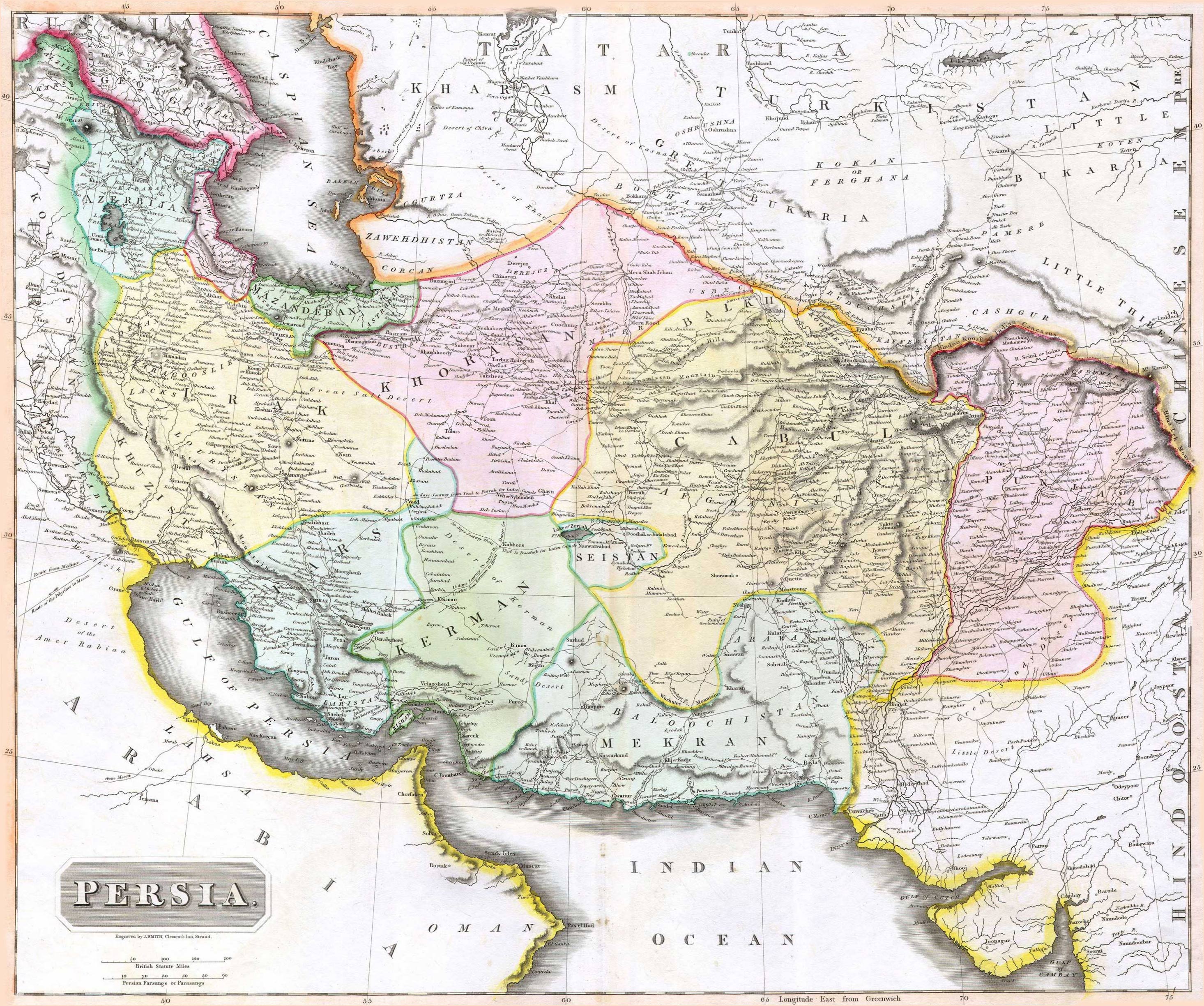
English: 1814 Thomson Map of Persia (Iran), engraved by J. Smith, Clement's Inn, Strand. |
| Dato | |
| Skaber |
J. Smith, Clement's Inn, Strand. |
| Geotemporal data | |
| Map location | Iran |
| Georeferencing | If inappropriate please set warp_status = skip to hide. |
| Bibliographic data | |
| Publikation |
New General Atlas (1821) |
| Forfatter |
John Thomson |
| Andre versioner | |

Licensering
The copyright situation of this work is theoretically uncertain, because in the country of origin copyright lasts 70 years after the death of the author, and the date of the author's death is unknown. However, the date of creation of the work was over 120 years ago, and it is thus a reasonable assumption that the copyright has expired (see here for the community discussion). Do not use this template if the date of death of the author is known.
Dette værk er offentlig ejendom i Amerikas Forenede Stater (USA) fordi det blev udgivet (eller registreret hos U.S. Copyright Office) før 1 januar 1929. | |
| Denne fil er blevet identificeret som værende fri for kendte restriktioner under lov om ophavsret, herunder alle relaterede og tilstødende rettigheder. | |
Filhistorik
Klik på en dato/tid for at se filen som den så ud på det tidspunkt.
| Dato/tid | Miniaturebillede | Dimensioner | Bruger | Kommentar | |
|---|---|---|---|---|---|
| nuværende | 18. aug. 2010, 09:27 | | 2.931 × 2.448 (1,6 MB) | Begoon | edge perspective and crop |
| 19. nov. 2006, 04:35 |  | 2.979 × 2.520 (1,45 MB) | Kaveh | == Summary == 1814 Thomson Map of Persia (Iran) Category:Maps of Iran == Licensing == {{PD-old}} |
Filanvendelse
Den følgende side bruger denne fil:
Global filanvendelse
Følgende andre wikier anvender denne fil:
- Anvendelser på ar.wikipedia.org
- Anvendelser på az.wikipedia.org
- Anvendelser på be.wikipedia.org
- Anvendelser på bn.wikipedia.org
- Anvendelser på bs.wikipedia.org
- Anvendelser på ca.wikipedia.org
- Anvendelser på de.wikipedia.org
- Anvendelser på en.wikipedia.org
- Anvendelser på es.wikipedia.org
- Anvendelser på eu.wikipedia.org
- Anvendelser på fa.wikipedia.org
- Anvendelser på fr.wikipedia.org
- Anvendelser på hi.wikipedia.org
- Anvendelser på hr.wikipedia.org
Vis flere globale anvendelser af denne fil.