Fil:1945-02-15GerWW2BattlefrontAtlas.jpg
Størrelse af denne forhåndsvisning: 616 × 600 pixels. Andre opløsninger: 247 × 240 pixels | 493 × 480 pixels | 789 × 768 pixels | 1.250 × 1.217 pixels.
Fuld opløsning (1.250 × 1.217 billedpunkter, filstørrelse: 1,26 MB, MIME-type: image/jpeg)
|
|
Denne fil er fra Wikimedia Commons. Beskrivelsen af filen fra Commons er gengivet nedenfor. |

|
Denne fil er blevet afløst af File:1945-02-15GerWW2BattlefrontAtlas reworked.jpg, og du bør derfor oftest benytte den anden fil i stedet. Denne fil vil dog ikke blive slettet, medmindre den udtrykkeligt bliver nomineret til sletning.
|

|
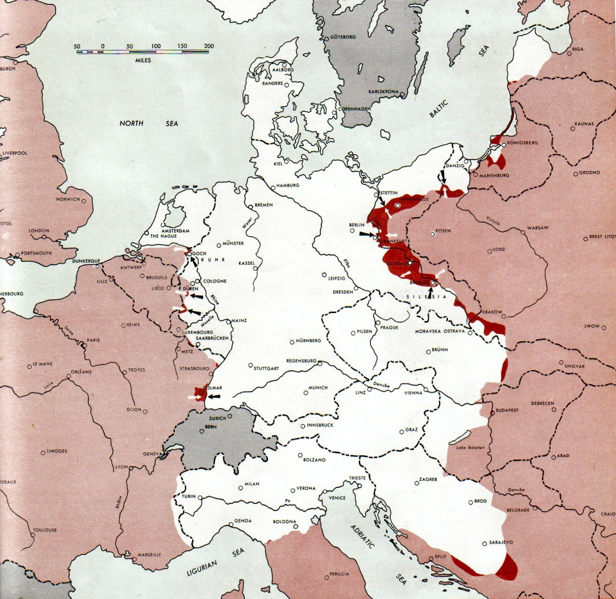
Atlas of the World Battle Fronts - War against Germany: 1945-02-15
← Previous map: 1945-02-01
→ Next map: 1945-03-01
Beskrivelse
| Beskrivelse |
Neutral nations (Sweden, Switzerland, Spain, Andorra)
Under Allied control
Allied forces
Axis forces or control
  July 1, 1943 to June 30 1945 To the Secretary of War". (See Cover, Forward and Map details)  |
| Dato | |
| Kilde | Document "Atlas of the World Battle Fronts in Semimonthly Phases to August 15th 1945: Supplement to The Biennial report of the Chief of Staff of the United States Army July 1, 1943 to June 30 1945 To the Secretary of War" |
| Forfatter | Army Map Service |
| Tilladelse (Genbrug af denne fil) |
Public Domain: Work of US army |
Licensering
This file is a work of a U.S. Army soldier or employee, taken or made as part of that person's official duties. As a work of the U.S. federal government, it is in the public domain in the United States.
|
 |
Filhistorik
Klik på en dato/tid for at se filen som den så ud på det tidspunkt.
| Dato/tid | Miniaturebillede | Dimensioner | Bruger | Kommentar | |
|---|---|---|---|---|---|
| nuværende | 28. aug. 2011, 11:15 | | 1.250 × 1.217 (1,26 MB) | Finavon | 1 degree rotation; caption cropped |
| 24. dec. 2007, 21:16 |  | 1.274 × 1.714 (1,78 MB) | Mike Young | {{Information |Description= thumb|left|75pxthumb|right|75pxMap of the front against Germany: This map is taken from the source "Atlas of the World Battle Fronts in Semimonthly |
Filanvendelse
Den følgende side bruger denne fil:
Global filanvendelse
Følgende andre wikier anvender denne fil:
- Anvendelser på be-tarask.wikipedia.org
- Anvendelser på en.wikipedia.org
- Anvendelser på en.wikisource.org
- Anvendelser på es.wikipedia.org
- Anvendelser på hu.wikipedia.org
- Anvendelser på hy.wikipedia.org
- Anvendelser på id.wikipedia.org
- Anvendelser på ko.wikipedia.org
- Anvendelser på no.wikipedia.org
- Anvendelser på ro.wikipedia.org
- Anvendelser på vi.wikipedia.org
- Anvendelser på zh.wikipedia.org