Fil:2010 haiti shake map.jpg
Størrelse af denne forhåndsvisning: 464 × 599 pixels. Andre opløsninger: 186 × 240 pixels | 516 × 666 pixels.
Fuld opløsning (516 × 666 billedpunkter, filstørrelse: 178 KB, MIME-type: image/jpeg)
|
|
Denne fil er fra Wikimedia Commons. Beskrivelsen af filen fra Commons er gengivet nedenfor. |
Beskrivelse
| Beskrivelse |
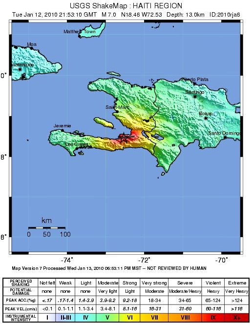
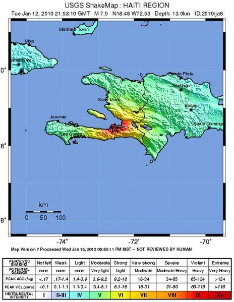
English: Shake map of 2010 Haiti earthquake |
| Dato | |
| Kilde | https://web.archive.org/web/20100115110631/https://earthquake.usgs.gov/earthquakes/shakemap/global/shake/2010rja6/ |
| Forfatter | USGS |
| Andre versioner | gg |
Licensering
This image is in the public domain in the United States because it only contains materials that originally came from the United States Geological Survey, an agency of the United States Department of the Interior. For more information, see the official USGS copyright policy.
|
Filhistorik
Klik på en dato/tid for at se filen som den så ud på det tidspunkt.
| Dato/tid | Miniaturebillede | Dimensioner | Bruger | Kommentar | |
|---|---|---|---|---|---|
| nuværende | 19. jan. 2010, 21:16 | | 516 × 666 (178 KB) | Fujnky | update and better quality |
| 15. jan. 2010, 16:42 |  | 543 × 672 (69 KB) | Dumelow | crop some whitespace | |
| 13. jan. 2010, 03:13 |  | 612 × 722 (83 KB) | Dumelow | {{Information |Description={{en|1=Shake map of 2010 Haiti earthquake}} |Source=http://earthquake.usgs.gov/earthquakes/shakemap/global/shake/2010rja6/ |Author=USGS |Date=12 jan 2010 |Permission= |other_versions= }} |
Filanvendelse
De følgende 2 sider bruger denne fil:
Global filanvendelse
Følgende andre wikier anvender denne fil:
- Anvendelser på bg.wikinews.org
- Anvendelser på de.wikipedia.org
- Anvendelser på en.wikipedia.org
- Anvendelser på en.wikinews.org
- Anvendelser på fi.wikipedia.org
- Anvendelser på fr.wikipedia.org
- Anvendelser på fr.wikinews.org
- Anvendelser på hi.wikipedia.org
- Anvendelser på hu.wikipedia.org
- Anvendelser på id.wikipedia.org
- Anvendelser på it.wikinews.org
- Anvendelser på ja.wikipedia.org
- Anvendelser på ki.wikipedia.org
- Anvendelser på lt.wikipedia.org
- Anvendelser på mk.wikipedia.org
- Anvendelser på ms.wikipedia.org
- Anvendelser på nds-nl.wikipedia.org
- Anvendelser på nl.wikipedia.org
- Anvendelser på pl.wikipedia.org
- Anvendelser på pl.wikinews.org
- Anvendelser på pt.wikipedia.org
- Anvendelser på pt.wikinews.org
- Anvendelser på sv.wikipedia.org
- Anvendelser på ta.wikipedia.org
- Anvendelser på tl.wikipedia.org
- Anvendelser på tr.wikipedia.org
- Anvendelser på uk.wikipedia.org
- Anvendelser på vi.wikipedia.org