Fil:Baghdad etm 2003092 lrg.jpg

Fuld opløsning (889 × 1.200 billedpunkter, filstørrelse: 458 KB, MIME-type: image/jpeg)
|
|
Denne fil er fra Wikimedia Commons. Beskrivelsen af filen fra Commons er gengivet nedenfor. |
| Beskrivelse |
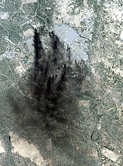
This image shows the city of Baghdad, the capital of Iraq. The dark smoke plumes are from pits of burning oil arrayed in a ring around the center of the city, a tactic used to stall and confuse invaders since medieval times. This picture is computer animated to show how it could look in reality. Baghdad Airport can be seen southwest of the city, just outside the smoke. This image was acquired by Landsat 7's Enhanced Thematic Mapper Plus (ETM+) sensor on April 2, 2003. |
|||||
| Dato | Image taken on April 2, 2003. | |||||
| Kilde | http://earthobservatory.nasa.gov/NaturalHazards/natural_hazards_v2.php3?img_id=10149 | |||||
| Forfatter | Image provided by the USGS EROS Data Center Satellite Systems Branch. | |||||
| Tilladelse (Genbrug af denne fil) |
|

Filhistorik
Klik på en dato/tid for at se filen som den så ud på det tidspunkt.
| Dato/tid | Miniaturebillede | Dimensioner | Bruger | Kommentar | |
|---|---|---|---|---|---|
| nuværende | 9. jan. 2006, 07:58 | | 889 × 1.200 (458 KB) | Slarre~commonswiki | This image shows the city of Baghdad, the capital of Iraq. The dark smoke plumes are from pits of burning oil arrayed in a ring around the center of the city, a tactic used to stall and confuse invaders since medieval times. Baghdad Airport can be seen so |
Filanvendelse
Den følgende side bruger denne fil:
Global filanvendelse
Følgende andre wikier anvender denne fil:
- Anvendelser på bg.wikipedia.org
- Anvendelser på ca.wikipedia.org
- Anvendelser på cs.wikipedia.org
- Anvendelser på cy.wikipedia.org
- Anvendelser på de.wikipedia.org
- Anvendelser på en.wikipedia.org
- Anvendelser på en.wikiquote.org
- Anvendelser på es.wikipedia.org
- Anvendelser på fi.wikipedia.org
- Anvendelser på fr.wikipedia.org
- Anvendelser på he.wikipedia.org
- Anvendelser på ko.wikipedia.org
- Anvendelser på no.wikipedia.org
- Anvendelser på pt.wikipedia.org
- Anvendelser på ru.wikipedia.org
- Anvendelser på sv.wikipedia.org
- Anvendelser på tr.wikipedia.org
- Anvendelser på uk.wikipedia.org
- Anvendelser på vi.wikipedia.org
- Anvendelser på zh-classical.wikipedia.org
- Anvendelser på zh.wikipedia.org