Fil:Breakwater break1 new(USGS).jpg

Fuld opløsning (1.493 × 984 billedpunkter, filstørrelse: 812 KB, MIME-type: image/jpeg)
|
|
Denne fil er fra Wikimedia Commons. Beskrivelsen af filen fra Commons er gengivet nedenfor. |
.jpg?uselang=da)
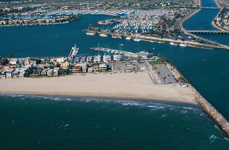
Breakwater.
Breakwaters create safe harbors but can also trap sediment moving along the coast. Long Beach Harbor, April, 1998
From: USGS
A more accurate description: The sand buildup shown is on the southeast end of the Long Beach Peninsula, with the jetty blocking the southward movement of sand being the west side of the entrance to Alamitos Bay. In the background, to the right of the center, is the Alamitos Bay Landing commercial area of the Long Beach Marina. To the far right in the back is the w:San Gabriel River. In the back top left is the sotheast end of w:Naples, a residential island in Alamitos Bay. The ocean shown in the foreground is the very southeast end of the Long Beach Outer Harbor.
Dette værk er offentlig ejendom fordi det er skabt af Amerikas Forenede Staters føderale regering, eller en person eller institution arbejdende for denne. Ifølge Titel 17, Kapitel 1, Sektion 105 af US Code er sådanne værker ikke omfattede af ophavsret.
Note: Dette gælder kun for værker af den Føderale Regering og ikke for værker af de enkelte delstater, territorier, commonwealth, amt, kommune, eller anden subnational enhed.
|
 | |
| Denne fil er blevet identificeret som værende fri for kendte restriktioner under lov om ophavsret, herunder alle relaterede og tilstødende rettigheder. | ||
Filhistorik
Klik på en dato/tid for at se filen som den så ud på det tidspunkt.
| Dato/tid | Miniaturebillede | Dimensioner | Bruger | Kommentar | |
|---|---|---|---|---|---|
| nuværende | 10. jun. 2010, 11:31 | | 1.493 × 984 (812 KB) | Quibik | cropped away 3 px from right edge and cloned the bottom edge a bit to remove black background |
| 10. jun. 2010, 11:28 |  | 1.496 × 984 (814 KB) | Quibik | removed the timestamp | |
| 11. dec. 2009, 20:05 |  | 1.496 × 984 (841 KB) | Foobaz | Larger version from http://coastal.er.usgs.gov/cgi-bin/response.pl?site=sc&loc=25 . | |
| 21. apr. 2005, 11:02 |  | 295 × 193 (9 KB) | Feydey | Breakwater. Breakwaters create safe harbors but can also trap sediment moving along the coast. Long Beach Harbor, April, 1998 From: [http://walrus.wr.usgs.gov/cabrillo/playa/breakwater.html USGS] {{PD-USGov}} |
Filanvendelse
Den følgende side bruger denne fil:
Global filanvendelse
Følgende andre wikier anvender denne fil:
- Anvendelser på az.wikipedia.org
- Anvendelser på el.wikipedia.org
- Anvendelser på en.wikipedia.org
- Anvendelser på fi.wikipedia.org
- Anvendelser på he.wikipedia.org
- Anvendelser på id.wikipedia.org
- Anvendelser på kn.wikipedia.org
- Anvendelser på ml.wikipedia.org
- Anvendelser på sco.wikipedia.org
- Anvendelser på simple.wikipedia.org
- Anvendelser på vi.wikipedia.org
.jpg)