Fil:Brong Ahafo districts.png

Størrelse af denne forhåndsvisning: 776 × 600 pixels. Andre opløsninger: 311 × 240 pixels | 621 × 480 pixels | 994 × 768 pixels | 1.056 × 816 pixels.
Fuld opløsning (1.056 × 816 billedpunkter, filstørrelse: 49 KB, MIME-type: image/png)
|
|
Denne fil er fra Wikimedia Commons. Beskrivelsen af filen fra Commons er gengivet nedenfor. |
Beskrivelse
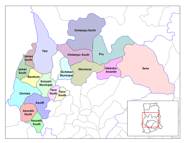
| Beskrivelse | Map of the districts of the Brong Ahafo region of Ghana. Created by Rarelibra for public domain use. Created using MapInfo Professional v7.5 and various mapping resources. |
| Dato | 28. juni 2006 (original upload date) |
| Kilde | No machine-readable source provided. Own work assumed (based on copyright claims). |
| Forfatter | No machine-readable author provided. Ahanta assumed (based on copyright claims). |
Licensering
| Jeg, indehaveren af ophavsretten til dette værk, udgiver dette værk som offentlig ejendom. Dette gælder i hele verden. I nogle lande er dette ikke juridisk muligt. I så fald: Jeg giver enhver ret til at anvende dette værk til ethvert formål, uden nogen restriktioner, medmindre sådanne restriktioner er påkrævede ved lov. |
Filhistorik
Klik på en dato/tid for at se filen som den så ud på det tidspunkt.
| Dato/tid | Miniaturebillede | Dimensioner | Bruger | Kommentar | |
|---|---|---|---|---|---|
| nuværende | 28. jun. 2006, 12:27 | | 1.056 × 816 (49 KB) | Ahanta | Map of the districts of the Brong Ahafo region of Ghana. Created by Rarelibra for public domain use. Created using MapInfo Professional v7.5 and various mapping resources. [edit] I, the creator of this work, hereby release it into the public domain. This |
Filanvendelse
Den følgende side bruger denne fil:
Global filanvendelse
Følgende andre wikier anvender denne fil:
- Anvendelser på ca.wikipedia.org
- Anvendelser på ceb.wikipedia.org
- Anvendelser på dag.wikipedia.org
- Anvendelser på de.wikipedia.org
- Anvendelser på dga.wikipedia.org
- Anvendelser på en.wikipedia.org
- Dormaa District
- Asutifi District
- Nkoranza District
- Sene District
- Atebubu District
- Pru District
- Jaman District
- Berekum-Jaman District
- Kintampo District
- Asunafo District
- User talk:Rarelibra/Maps2
- List of hospitals in Ghana
- List of Ghana Parliament constituencies
- Nsoatre
- User:GerardM/Districts of Ghana
- Tano District, Ghana
- Anvendelser på es.wikipedia.org
- Anvendelser på fa.wikipedia.org
- Anvendelser på frr.wikipedia.org
- Anvendelser på fr.wikipedia.org
Vis flere globale anvendelser af denne fil.