Fil:Cabinda pol77.jpg

Størrelse af denne forhåndsvisning: 455 × 599 pixels. Andre opløsninger: 182 × 240 pixels | 364 × 480 pixels | 583 × 768 pixels | 1.040 × 1.370 pixels.
Fuld opløsning (1.040 × 1.370 billedpunkter, filstørrelse: 160 KB, MIME-type: image/jpeg)
|
|
Denne fil er fra Wikimedia Commons. Beskrivelsen af filen fra Commons er gengivet nedenfor. |

|
En vektorversion af dette billede (SVG) er tilgængelig. Det bør bruges i stedet for punktgrafikbilledet når det er fordelagtigt.
File:Cabinda pol77.jpg → File:Cabinda map-fr.svg
For mere information om vektorgrafik: Læs om overgangen til SVG på Commons. Se også information om MediaWikis understøttelse af SVG-billeder. |
 |
Beskrivelse
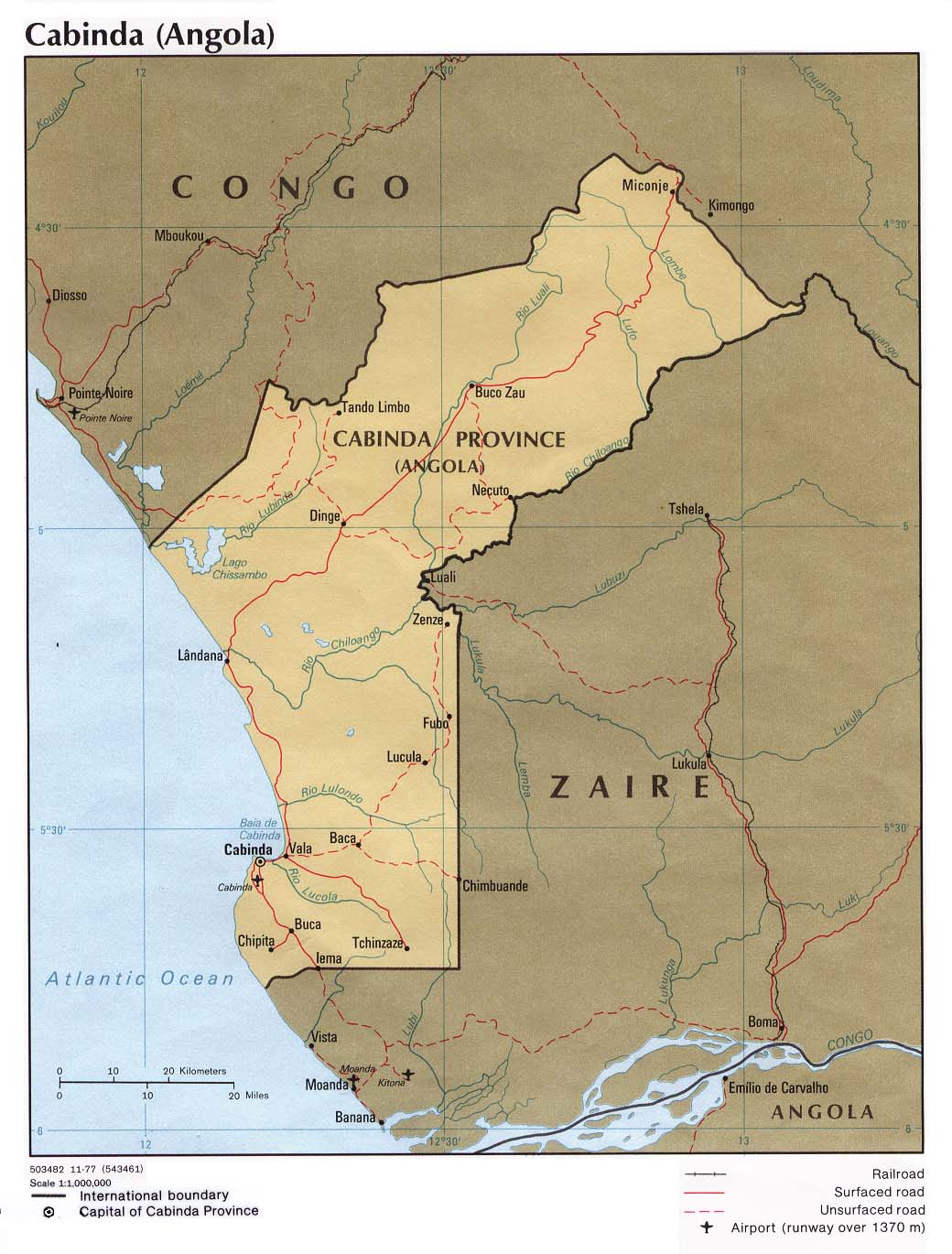
| Beskrivelse | Political map of the Cabinda province, Angola. |
| Dato | |
| Kilde | University of Texas Libraries, Perry-Castañeda Library Map Collection: Angola Maps |
| Forfatter | CIA |
| Andre versioner | Derivative works of this file: Cabinda map-fr.svg |
Licensering
| This image is a work of a Central Intelligence Agency employee, taken or made as part of that person's official duties. As a Work of the United States Government, this image or media is in the public domain in the United States.
|

|
derivative works
Filhistorik
Klik på en dato/tid for at se filen som den så ud på det tidspunkt.
| Dato/tid | Miniaturebillede | Dimensioner | Bruger | Kommentar | |
|---|---|---|---|---|---|
| nuværende | 23. apr. 2007, 20:34 | | 1.040 × 1.370 (160 KB) | Kipala | http://www.lib.utexas.edu/maps/africa/cabinda_pol77.jpg From the Perry Castaneda Map Collection "Courtesy of the University of Texas Libraries, The University of Texas at Austin." |
Filanvendelse
Den følgende side bruger denne fil:
Global filanvendelse
Følgende andre wikier anvender denne fil:
- Anvendelser på ar.wikipedia.org
- Anvendelser på azb.wikipedia.org
- Anvendelser på br.wikipedia.org
- Anvendelser på ca.wikipedia.org
- Anvendelser på co.wikipedia.org
- Anvendelser på cy.wikipedia.org
- Anvendelser på de.wikipedia.org
- Anvendelser på el.wikipedia.org
- Anvendelser på en.wikipedia.org
- Anvendelser på eo.wikipedia.org
- Anvendelser på eo.wikivoyage.org
- Anvendelser på es.wikipedia.org
- Anvendelser på eu.wikipedia.org
- Anvendelser på fa.wikipedia.org
- Anvendelser på fi.wikipedia.org
- Anvendelser på fo.wikipedia.org
- Anvendelser på fr.wikipedia.org
- Anvendelser på ha.wikipedia.org
- Anvendelser på he.wikipedia.org
- Anvendelser på hu.wikipedia.org
- Anvendelser på it.wikipedia.org
- Anvendelser på ka.wikipedia.org
- Anvendelser på kg.wikipedia.org
- Anvendelser på ko.wikipedia.org
- Anvendelser på la.wikipedia.org
- Anvendelser på ln.wikipedia.org
- Anvendelser på lt.wikipedia.org
- Anvendelser på mk.wikipedia.org
- Anvendelser på nl.wikipedia.org
- Anvendelser på nn.wikipedia.org
- Anvendelser på no.wikipedia.org
Vis flere globale anvendelser af denne fil.