Fil:China-Jiangsu.png
Der findes ingen højere opløsning af billedet
China-Jiangsu.png (268 × 218 billedpunkter, filstørrelse: 16 KB, MIME-type: image/png)
|
|
Denne fil er fra Wikimedia Commons. Beskrivelsen af filen fra Commons er gengivet nedenfor. |
Beskrivelse
| Beskrivelse |
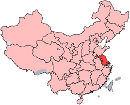
English: Location of Jiangsu Province in the People's Republic of China. See Locator maps of province-level divisions of the People's Republic of China for more information.
中文:江蘇省在中華人民共和國的位置。另見Locator maps of province-level divisions of the People's Republic of China. |
| Kilde | |
| Forfatter |
Licensering

|
Tilladelse er givet til at kopiere, distribuere og/eller ændre dette dokument under betingelserne i GNU Free Documentation License', Version 1.2 eller enhver senere version udgivet af Free Software Foundation; uden et invariant afsnit, ingen forsidetekster, og ingen bagsidetekst. En kopi af licensen er inkluderet i afsnittet GNU Free Documentation License. |
| Denne fil er udgivet under Creative Commons Kreditering-Del på samme vilkår 3.0 Ikke-porteret-licensen. | ||
| ||
| Denne licens blev tilføjet som en del af GFDL-licensopdateringen. |
Filhistorik
Klik på en dato/tid for at se filen som den så ud på det tidspunkt.
| Dato/tid | Miniaturebillede | Dimensioner | Bruger | Kommentar | |
|---|---|---|---|---|---|
| nuværende | 15. jul. 2005, 16:48 | | 268 × 218 (16 KB) | Schaengel89~commonswiki | transparent background |
| 4. jun. 2005, 23:49 |  | 268 × 218 (9 KB) | Ran | '''en''': Location of Jiangsu Province in the People's Republic of China. See Category:Locator maps of province-level divisions of the People's Republic of China for more information. '''zh''': 江蘇省在中華人民共和國的位置。另見[[:C | |
| 22. apr. 2005, 18:38 |  | 268 × 218 (8 KB) | Airunp | Jiangsu location. Localización de Jiangsu Ran from en: wikipedia {{GFDL}} Category:Maps of China |
Filanvendelse
Den følgende side bruger denne fil:
Global filanvendelse
Følgende andre wikier anvender denne fil:
- Anvendelser på ar.wikipedia.org
- Anvendelser på cy.wikipedia.org
- Anvendelser på en.wikipedia.org
- Liyang
- Luoma Lake
- Wikipedia:WikiProject Chinese provinces/Locator maps
- Pizhou
- Yangjian
- Stone City (Nanjing)
- Heheng
- Weiyang District, Yangzhou
- Binhai County
- Xiaolingwei
- Yueya Lake (Nanjing)
- Nanchang District
- Suining County, Jiangsu
- Waikejiao
- Macaiheng
- Sheyang County
- Jianhu County
- Rudong County
- Xinghua, Jiangsu
- Pukou, Nanjing
- Lianyungang Baitabu Airport
- Xuzhou Guanyin International Airport
- Template:Jiangsu-geo-stub
- Biluochun
- Protein adulteration in China
- Shidian, Rudong County
- Yancheng Coastal Wetlands
- Wangtan, Jiangsu
- Jiawang, Xuzhou
- Chong'an District
- Touzao
- Jurong, Jiangsu
- Xinjiekou, Nanjing
- Xinbei, Changzhou
- Tianning, Changzhou
- Zhonglou, Changzhou
- Qishuyan District
- Qixia, Nanjing
- Jingkou, Zhenjiang
- Runzhou, Zhenjiang
- Dantu, Zhenjiang
- Beitang District
- Binhu, Wuxi
- Hai'an
- Xishan, Wuxi
- Huishan, Wuxi
- Gangzha District
Vis flere globale anvendelser af denne fil.