Fil:EASTSIDE PLANT- GENERAL VIEW OF GENERATOR AND EXCITER - American Falls Water, Power and Light Company, Island Power Plant, Snake River, below American Falls Dam, American Falls, HAER ID,39-AMFA,1-49.tif

Size of this JPG preview of this TIF file: 768 × 600 pixels. Andre opløsninger: 307 × 240 pixels | 615 × 480 pixels | 983 × 768 pixels | 1.280 × 1.000 pixels | 2.560 × 1.999 pixels | 4.685 × 3.659 pixels.
Fuld opløsning (4.685 × 3.659 billedpunkter, filstørrelse: 16,35 MB, MIME-type: image/tiff)
|
|
Denne fil er fra Wikimedia Commons. Beskrivelsen af filen fra Commons er gengivet nedenfor. |
Beskrivelse
| EASTSIDE PLANT- GENERAL VIEW OF GENERATOR AND EXCITER - American Falls Water, Power and Light Company, Island Power Plant, Snake River, below American Falls Dam, American Falls, Power County, ID | ||||
|---|---|---|---|---|
| Fotograf |
Related names:
|
|||
| Titel |
EASTSIDE PLANT- GENERAL VIEW OF GENERATOR AND EXCITER - American Falls Water, Power and Light Company, Island Power Plant, Snake River, below American Falls Dam, American Falls, Power County, ID |
|||
| Depicted place | Idaho; Power County; American Falls | |||
| Dato | Documentation compiled after 1968 | |||
| Mål | 4 x 5 in. | |||
| Nuværende placering |
Library of Congress Prints and Photographs Division Washington, D.C. 20540 USA http://hdl.loc.gov/loc.pnp/pp.print |
|||
| Museumsnummer |
HAER ID,39-AMFA,1-49 |
|||
| Samling og anskaffelsesmetode |
|
|||
| Noter |
|
|||
| Kilde | https://www.loc.gov/pictures/item/id0011.photos.060045p | |||
| Tilladelse (Genbrug af denne fil) |
|
|||

| Objektposition | | Dette og andre billeder på deres position på: OpenStreetMap |
|---|
Filhistorik
Klik på en dato/tid for at se filen som den så ud på det tidspunkt.
| Dato/tid | Miniaturebillede | Dimensioner | Bruger | Kommentar | |
|---|---|---|---|---|---|
| nuværende | 29. jan. 2023, 00:58 |  | 4.685 × 3.659 (16,35 MB) | Tholme | Cropped 6 % horizontally, 9 % vertically using CropTool with lossless mode. |
| 14. jul. 2014, 19:02 | 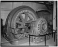 | 4.971 × 3.999 (18,96 MB) | Fæ | GWToolset: Creating mediafile for Fæ. HABS 11 July 2014 (1001:1200) |
Filanvendelse
Den følgende side bruger denne fil:
Global filanvendelse
Følgende andre wikier anvender denne fil:
- Anvendelser på no.wikipedia.org