Fil:ElectoralCollege1984-Large.png
Størrelse af denne forhåndsvisning: 800 × 430 pixels. Andre opløsninger: 320 × 172 pixels | 640 × 344 pixels | 1.182 × 635 pixels.
Fuld opløsning (1.182 × 635 billedpunkter, filstørrelse: 163 KB, MIME-type: image/png)
|
|
Denne fil er fra Wikimedia Commons. Beskrivelsen af filen fra Commons er gengivet nedenfor. |
| U.S. presidential election maps from the National Atlas of the United States |
| See also: SVG maps |
| 1789 · 1792 · 1796 · 1800 · 1804 · 1808 · 1812 · 1816 · 1820 · 1824 · 1828 · 1832 · 1836 · 1840 · 1844 · 1848 · 1852 · 1856 · 1860 · 1864 · 1868 · 1872 · 1876 · 1880 · 1884 · 1888 · 1892 · 1896 · 1900 · 1904 · 1908 · 1912 · 1916 · 1920 · 1924 · 1928 · 1932 · 1936 · 1940 · 1944 · 1948 · 1952 · 1956 · 1960 · 1964 · 1968 · 1972 · 1976 · 1980 · 1984 · 1988 · 1992 · 1996 · 2000 · 2004 |
Beskrivelse
| Beskrivelse |
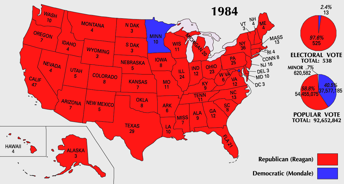
English: 1984 Electoral College Map |
|||
| Kilde | https://nationalmap.gov/small_scale/printable/elections.html | |||
| Forfatter | United States Geological Survey | |||
| Andre versioner |
|


Licensering
This map was obtained from an edition of the National Atlas of the United States. Like almost all works of the U.S. federal government, works from the National Atlas are in the public domain in the United States.
Online access: NationalAtlas.gov | 1970 print edition: Library of Congress, Perry-Castañeda Library
|
Filhistorik
Klik på en dato/tid for at se filen som den så ud på det tidspunkt.
| Dato/tid | Miniaturebillede | Dimensioner | Bruger | Kommentar | |
|---|---|---|---|---|---|
| nuværende | 25. jul. 2007, 12:20 | | 1.182 × 635 (163 KB) | Cardsplayer4life~commonswiki | Reverted to earlier revision |
| 25. jul. 2007, 11:32 |  | 1.182 × 635 (104 KB) | Joseph Solis in Australia~commonswiki | {{PD-USGov-Atlas}} Category:1988 {{US presidential election maps}} | |
| 9. jul. 2007, 03:46 |  | 1.182 × 635 (163 KB) | Cardsplayer4life~commonswiki | {{PD-USGov-Atlas}} Category:1984 {{US presidential election maps}} | |
| 6. jul. 2007, 11:36 |  | 1.182 × 635 (104 KB) | Joseph Solis in Australia~commonswiki | {{PD-USGov-Atlas}} Category:1984 {{US presidential election maps}} | |
| 2. jul. 2007, 04:28 |  | 1.182 × 635 (163 KB) | Cardsplayer4life~commonswiki | {{PD-USGov-Atlas}} Category:1984 {{US presidential election maps}} | |
| 29. jun. 2007, 12:14 |  | 1.182 × 635 (104 KB) | Joseph Solis in Australia~commonswiki | {{PD-USGov-Atlas}} Category:1984 {{US presidential election maps}} | |
| 21. jun. 2007, 23:07 |  | 1.182 × 635 (163 KB) | Cardsplayer4life~commonswiki | {{PD-USGov-Atlas}} Category:1984 {{US presidential election maps}} | |
| 31. maj 2007, 10:27 |  | 1.182 × 635 (104 KB) | Joseph Solis in Australia~commonswiki | {{PD-USGov-Atlas}} Category:1984 {{US presidential election maps}} | |
| 25. maj 2006, 22:06 |  | 1.182 × 635 (89 KB) | JP06035 | switched colors | |
| 22. jan. 2006, 18:08 |  | 1.182 × 635 (104 KB) | Red devil 666 | {{PD-USGov-Atlas}} |
Filanvendelse
Der er ingen sider der bruger denne fil.
Global filanvendelse
Følgende andre wikier anvender denne fil:
- Anvendelser på hu.wikipedia.org