Fil:Farah province detail map.png
Farah_province_detail_map.png (458 × 294 billedpunkter, filstørrelse: 23 KB, MIME-type: image/png)
|
|
Denne fil er fra Wikimedia Commons. Beskrivelsen af filen fra Commons er gengivet nedenfor. |
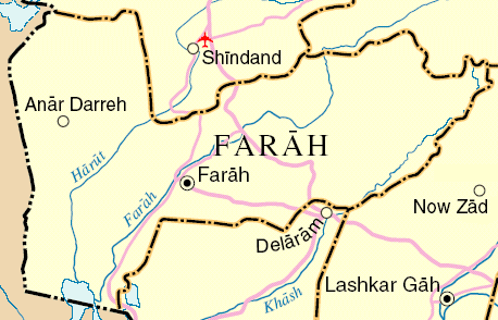
Map of Farah Province, Afghanistan
Adapted from http://www.un.org/Depts/Cartographic/map/profile/afghanis.pdf
| This image is a map derived from a United Nations map.
Unless stated otherwise, UN maps are to be considered in the public domain. This applies worldwide. UN maps are, in principle, open source material and you can use them in your work or for making your own map. UN requests however that you delete the UN name, logo and reference number upon any modification to the map. Content of your map will be your responsibility. You can state in your publication, if you wish, something like: based on UN map … (map name, map number, revision number and date). See: Geospatial Information Section. And: Geospatial, location data for a better world. |
 |
Filhistorik
Klik på en dato/tid for at se filen som den så ud på det tidspunkt.
| Dato/tid | Miniaturebillede | Dimensioner | Bruger | Kommentar | |
|---|---|---|---|---|---|
| nuværende | 31. jul. 2006, 13:16 | | 458 × 294 (23 KB) | Dodo | Map of Farah Province, Afghanistan Adapted from http://www.un.org/Depts/Cartographic/map/profile/afghanis.pdf {{UN map}} Category:Maps of Afghanistan |
Filanvendelse
Den følgende side bruger denne fil:
Global filanvendelse
Følgende andre wikier anvender denne fil:
- Anvendelser på es.wikipedia.org
- Anvendelser på fa.wikipedia.org
- Anvendelser på fr.wikipedia.org
- Anvendelser på it.wikipedia.org
- Anvendelser på it.wikinews.org
- Anvendelser på ja.wikipedia.org
- Anvendelser på sr.wikipedia.org
- Anvendelser på tr.wikipedia.org