Fil:Horst graben.jpg
Der findes ingen højere opløsning af billedet
Horst_graben.jpg (271 × 135 billedpunkter, filstørrelse: 41 KB, MIME-type: image/jpeg)
|
|
Denne fil er fra Wikimedia Commons. Beskrivelsen af filen fra Commons er gengivet nedenfor. |
Beskrivelse
| Beskrivelse |
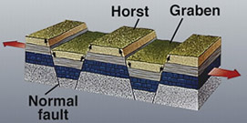
Deutsch: Diagram zur geolog. Struktur von Horsten und Graben.
|
|||
| Dato | Ukendt dato | |||
| Kilde | https://earthquake.usgs.gov/learning/glossary.php?term=graben | |||
| Forfatter | U.S. Geological Survey | |||
| Tilladelse (Genbrug af denne fil) |
|
|||
| Andre versioner |
Derivative works of this file: |

|
En vektorversion af dette billede (SVG) er tilgængelig. Det bør bruges i stedet for punktgrafikbilledet når det er fordelagtigt.
File:Horst graben.jpg → File:Fault-Horst-Graben.svg
For mere information om vektorgrafik: Læs om overgangen til SVG på Commons. Se også information om MediaWikis understøttelse af SVG-billeder. |
 |
Filhistorik
Klik på en dato/tid for at se filen som den så ud på det tidspunkt.
| Dato/tid | Miniaturebillede | Dimensioner | Bruger | Kommentar | |
|---|---|---|---|---|---|
| nuværende | 6. dec. 2008, 15:29 | | 271 × 135 (41 KB) | Woudloper | {{Information |Description=Schematic cross-section through part of the upper crust under extensional tectonics where horsts and grabens formed. |Source= |Date= |Author= |Permission= |other_versions= }} {{PD-USGov-USG |
| 13. dec. 2005, 19:48 |  | 346 × 260 (19 KB) | Angrense | Diagram of a rift formation. Source: {{PD-USGov-Interior-USGS}} from http://earthquake.usgs.gov/image_glossary/horst.html | |
| 25. aug. 2005, 19:36 |  | 346 × 260 (19 KB) | Slawojar | geological structure of horst and graben {{PD-USGov-USGS}} en:Image:Horst graben.jpg Category:Geology |
Filanvendelse
De følgende 2 sider bruger denne fil:
Global filanvendelse
Følgende andre wikier anvender denne fil:
- Anvendelser på ast.wikipedia.org
- Anvendelser på az.wikipedia.org
- Anvendelser på bg.wikipedia.org
- Anvendelser på bn.wikipedia.org
- Anvendelser på ca.wikipedia.org
- Anvendelser på en.wikipedia.org
- Anvendelser på en.wikibooks.org
- Anvendelser på eu.wikipedia.org
- Anvendelser på fa.wikipedia.org
- Anvendelser på fi.wikipedia.org
- Anvendelser på fr.wikipedia.org
- Anvendelser på gl.wikipedia.org
- Anvendelser på he.wikipedia.org
- Anvendelser på hy.wikipedia.org
- Anvendelser på id.wikipedia.org
- Anvendelser på it.wikipedia.org
- Anvendelser på it.wikibooks.org
- Anvendelser på it.wikiversity.org
- Anvendelser på ja.wikipedia.org
- Anvendelser på ka.wikipedia.org
- Anvendelser på kk.wikipedia.org
- Anvendelser på ko.wikipedia.org
- Anvendelser på nn.wikipedia.org
- Anvendelser på no.wikipedia.org
- Anvendelser på pl.wiktionary.org
- Anvendelser på pt.wikipedia.org
- Anvendelser på rm.wikipedia.org
- Anvendelser på ru.wikipedia.org
- Anvendelser på sk.wikipedia.org
- Anvendelser på tg.wikipedia.org
- Anvendelser på vi.wikipedia.org
- Anvendelser på www.wikidata.org
- Anvendelser på zh.wikipedia.org
Vis flere globale anvendelser af denne fil.