Fil:Messina-waves-image.jpg

Størrelse af denne forhåndsvisning: 387 × 600 pixels. Andre opløsninger: 155 × 240 pixels | 309 × 480 pixels | 495 × 768 pixels | 660 × 1.024 pixels | 1.321 × 2.048 pixels | 3.870 × 6.000 pixels.
Fuld opløsning (3.870 × 6.000 billedpunkter, filstørrelse: 4,28 MB, MIME-type: image/jpeg)
|
|
Denne fil er fra Wikimedia Commons. Beskrivelsen af filen fra Commons er gengivet nedenfor. |
| Beskrivelse |
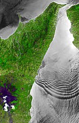
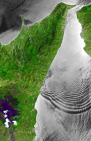
English: The Strait of Messina is a narrow channel separating the island of Sicily from the Italian peninsula, connecting the Ionian Sea with the Tyrrhenian Sea. In the Strait, strong tidal currents occur, which interact with the shallow sill located in its center. The mean depth of the Strait is only 80 m, compared to depths of over 800 m to the south. Internal wave trains of solitary waves can be generated, and these show up as sea surface manifestations because they are associated with variable surface currents that modify the surface roughness. ASTER sees these as dark (smooth) and light (rough) patterns when the solar illumination is at the correct angle relative to the orientation of the satellite. The ASTER images cover an area of 58 km x 90 km.
Deutsch: Die Straße von Messina ist eine Meerenge, die die Insel Sizilien von der italienischen Halbinsel trennt und das Ionische Meer mit dem Tyrrhenischen Meer verbindet. Hier treten starke Gezeitenströmungen auf, die mit der flachen Schwelle in ihrer Mitte interagieren. Die durchschnittliche Tiefe der Meerenge beträgt nur 80 m, im Vergleich zu Tiefen von über 800 m im Süden. Solitärwellen können Züge von internen Wellen erzeugen, und diese wirken auf die Meeresoberfläche, weil sie sich mit variablen Oberflächenströmungen überlagern und dabei die Oberflächenrauheit verändern. ASTER sieht diese Erscheinungen als dunkle (glatte) und helle (raue) Muster, wenn die Sonnenbeleuchtung im richtigen Winkel zur Ausrichtung des Satelliten steht. Die ASTER-Aufnahmen erstrecken sich über eine Fläche von 58 km x 90 km. |
| Dato | |
| Kilde | http://asterweb.jpl.nasa.gov/gallery-detail.asp?name=messina-wave |
| Forfatter |
NASA/GSFC/METI/ERSDAC/JAROS, and U.S./Japan ASTER Science Team |
| Objektposition | | Dette og andre billeder på deres position på: OpenStreetMap |
|---|
Licensering
| Denne fil er i offentligt domæne i USA fordi den udelukkende er skabt af NASA. NASAs ophavsretspolitik erklærer at materiale udgivet af NASA ikke er omfattet af ophavsret medmindre andet er nævnt. (Se også Template:PD-USGov, NASAs ophavsretspolitik eller JPLs politik for brug af billeder.) | ||
 |
Advarsler:
|
Oprindelig oplægningslog
The original description page was here. All following user names refer to de.wikipedia.
| Upload date | User | Bytes | Dimensions | Comment |
|---|---|---|---|---|
| 2009-06-02 22:17:24 | Herbertweidner | 4484167 | 3870×6000 | {{Information |Beschreibung = The Strait of Messina is a narrow channel separating the island of Sicily from the Italian peninsula, connecting the Ionian Sea with the Tyrrhenian Sea. In the Strait, strong tidal currents occur, which interact with the shal |
Filhistorik
Klik på en dato/tid for at se filen som den så ud på det tidspunkt.
| Dato/tid | Miniaturebillede | Dimensioner | Bruger | Kommentar | |
|---|---|---|---|---|---|
| nuværende | 29. mar. 2010, 02:31 | | 3.870 × 6.000 (4,28 MB) | CommonsHelper2 Bot | {{BotMoveToCommons|de.wikipedia|year={{subst:CURRENTYEAR}}|month={{subst:CURRENTMONTHNAME}}|day={{subst:CURRENTDAY}}}} {{Information |Description = {{de |The Strait of Messina is a narrow channel separating the island of Sicily from the Italian peninsul |
Filanvendelse
Den følgende side bruger denne fil:
Global filanvendelse
Følgende andre wikier anvender denne fil:
- Anvendelser på de.wikipedia.org
- Anvendelser på en.wikipedia.org
- Anvendelser på es.wikipedia.org
- Anvendelser på it.wikipedia.org
- Anvendelser på nl.wikipedia.org
- Anvendelser på simple.wikipedia.org
- Anvendelser på www.wikidata.org