Fil:Mount Rainier Hazard Map-en.svg

Size of this PNG preview of this SVG file: 501 × 599 pixels. Andre opløsninger: 201 × 240 pixels | 401 × 480 pixels | 642 × 768 pixels | 856 × 1.024 pixels | 1.713 × 2.048 pixels | 1.059 × 1.266 pixels.
Fuld opløsning (SVG fil, basisstørrelse 1.059 × 1.266 pixels, filstørrelse: 2,46 MB)
|
|
Denne fil er fra Wikimedia Commons. Beskrivelsen af filen fra Commons er gengivet nedenfor. |
Beskrivelse
| Beskrivelse |
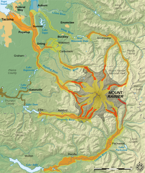
English: Hazard map around the Mount Rainier, state of Washington, United States.
Lava flow and pyroclastic flows
Electron Mudflow-sized event (generally large in size)
National Lahar-sized event (generally moderate in size)
Lahars not necessarily associated to volcanism (generally small)
Flooding after lahar event
Potential area of inundation from failure of Alder Dam
County boundary
Mount Rainier National Park boundary
City Esperanto: Mapo pri riskoj ĉirkaŭ Monto Rainier, Vaŝingtonio, Usono.
Lafa fluo kaj piroklastaj fluoj
Grandskalaj laharoj (tipo "Electron")
Moderaskalaj laharoj (tipo "National")
Laharoj ne certe asociitaj al vulkanaĵoj (ĝenerale malgrandskalaj)
Inundoj post lahara evento
Eventuala inunda regiono okaze de rompiĝo de Digo Alder
Kantona limo
Limo de Nacia Parko Mount Rainier
Urbo Français : Carte des risques liés au volcanisme du Mont Rainier, état de Washington, États-Unis.
Coulées de laves et coulées pyroclastiques
Lahars de grande taille (Type Electron)
Lahars de taille moyenne
Coulées de boues de petite taille (généralement non associées au volcanisme)
Inondations induites par des lahars
Zone potentiellement inondable suite à la rupture du barrage Alder
Limites de comtés
Limites du parc national du mont Rainier
Ville |
||
| Dato | |||
| Kilde |
English: Eget arbejde. Data sources :
Softwares used :
Others :
Français : Eget arbejde. Source des données :
Logiciels utilisés :
Données géographiques :
|
||
| Forfatter | Sémhur | ||
| Andre versioner |
|
||
| Kreditering (required by the license) | © Sémhur / Wikimedia Commons / | ||
| SVG | W3C-validity not checked. Vektorgrafikken blev lavet med Inkscape.
.
|
||
| Atelier graphique |

| Kameraposition | | Dette og andre billeder på deres position på: OpenStreetMap |
|---|
Licensering
This image is in the public domain in the United States because it only contains materials that originally came from the United States Geological Survey, an agency of the United States Department of the Interior. For more information, see the official USGS copyright policy.
|
Filhistorik
Klik på en dato/tid for at se filen som den så ud på det tidspunkt.
| Dato/tid | Miniaturebillede | Dimensioner | Bruger | Kommentar | |
|---|---|---|---|---|---|
| nuværende | 20. dec. 2007, 12:18 | | 1.059 × 1.266 (2,46 MB) | Sémhur | Correcting some labels |
| 10. dec. 2007, 13:17 |  | 1.059 × 1.266 (2,46 MB) | Sémhur | == Picture keys == {{legend|#aaa788|Lava flow and pyroclastic flows}} {{legend|#cdcb54|Electron Mudflow-sized event (generally large in size)}} {{legend|#e59b36|National Lahar-sized event (generally moderate in size)}} {{legend|#e45218|Lahars not necessar |
Filanvendelse
Den følgende side bruger denne fil:
Global filanvendelse
Følgende andre wikier anvender denne fil:
- Anvendelser på bg.wikipedia.org
- Anvendelser på cs.wikipedia.org
- Anvendelser på de.wikipedia.org
- Anvendelser på el.wikipedia.org
- Anvendelser på en.wikipedia.org
- Anvendelser på en.wikiversity.org
- Anvendelser på eo.wikipedia.org
- Anvendelser på es.wikipedia.org
- Anvendelser på he.wikipedia.org
- Anvendelser på it.wikipedia.org
- Anvendelser på it.wikiversity.org
- Anvendelser på ja.wikipedia.org
- Anvendelser på vi.wikipedia.org