Cheshire er et grevskab i England med Chester som administrationsby. Grevskabet tilhører regionen North West England og grænser op til Merseyside, Stor-Manchester, Derbyshire, Staffordshire og Shropshire samt det walisiske grevskab Clwyd. Pr. 2002 boede der 986.079 indbyggere i grevskabet, som totalt dækker et areal på 2.343 km².
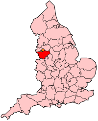
Cheshires placering i England

Cheshire er opdelt i fire områder; Cheshire East, Cheshire West and Chester, Halton og Warrington. Den største by er Warrington, mens Chester er county town.

# By Council area Indbyggertal[1][2][3][4][5]
2001 2011 2021
1 Warrington Warrington 157,860 165,456 174,954
2 Chester Cheshire West and Chester 81,650 86,011 92,742
3 Crewe Cheshire East 67,760 71,722 74,123
4 Runcorn Halton 60,320 61,789 61,635
5 Widnes Halton 55,680 61,464 59,939
6 Ellesmere Port Cheshire West and Chester 62,510 61,090 65,421
7 Macclesfield Cheshire East 54,440 56,581 54,340
8 Northwich Cheshire West and Chester 42,820 45,471 50,531
9 Winsford Cheshire West and Chester 29,440 30,259 35,000
10 Wilmslow Cheshire East 34,090 35,945 26,000
11 Congleton Cheshire East 25,510 26,178
12 Sandbach Cheshire East 17,630 17,976
13 Nantwich Cheshire East 13,450 17,226
14 Poynton Cheshire East 15,442 15,282
15 Neston Cheshire West and Chester 15,018 15,064
16 Middlewich Cheshire East 13,100 13,595
17 Alsager Cheshire East 14,178 13,347
18 Knutsford Cheshire East 12,656 13,191
19 Lymm Warrington 9,830 11,608
20 Frodsham Cheshire West and Chester 8,908 9,032
21 Bollington Cheshire East 6,880 7,373
22 Culcheth Warrington 6,730 6,708
23 Weaverham Cheshire West and Chester 6,293 6,087
24 Holmes Chapel Cheshire East 5,669 5,605
25 Helsby Cheshire West and Chester 4,911 5,166
26 Haslington Cheshire East 5,075 4,855

Se også

redigér

Referencer

redigér
  1. ^ "Warrington (Unitary District, North West England, United Kingdom) – Population Statistics, Charts, Map and Location". www.citypopulation.de (engelsk).
  2. ^ "Cheshire West and Chester (Unitary District, North West England, United Kingdom) – Population Statistics, Charts, Map and Location". www.citypopulation.de (engelsk).
  3. ^ "Cheshire East (Unitary District, North West England, United Kingdom) – Population Statistics, Charts, Map and Location". www.citypopulation.de (engelsk).
  4. ^ "Halton (Unitary District, North West England, United Kingdom) – Population Statistics, Charts, Map and Location". www.citypopulation.de (engelsk).
  5. ^ 2011 census table: ONS
 
Wikimedia Commons har medier relateret til:

53°10′00″N 2°35′00″V / 53.166666666667°N 2.5833333333333°V / 53.166666666667; -2.5833333333333