Fil:Kuril Benioff zone.JPG
Der findes ingen højere opløsning af billedet
Kuril_Benioff_zone.JPG (425 × 305 billedpunkter, filstørrelse: 17 KB, MIME-type: image/jpeg)
|
|
Denne fil er fra Wikimedia Commons. Beskrivelsen af filen fra Commons er gengivet nedenfor. |
Beskrivelse
| Beskrivelse |
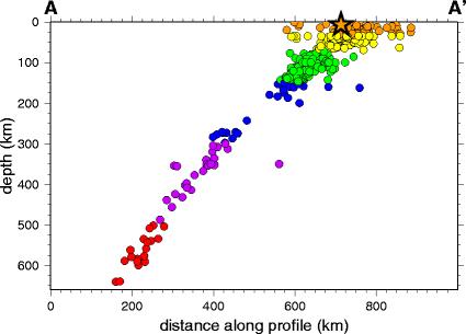
English: Seismicity cross-section across part of the Kuril Islands subduction zone |
| Dato | |
| Kilde | USGS page on Kuril earthquake 2006 [1] |
| Forfatter | USGS |
Licensering
This image is in the public domain in the United States because it only contains materials that originally came from the United States Geological Survey, an agency of the United States Department of the Interior. For more information, see the official USGS copyright policy.
|
Filhistorik
Klik på en dato/tid for at se filen som den så ud på det tidspunkt.
| Dato/tid | Miniaturebillede | Dimensioner | Bruger | Kommentar | |
|---|---|---|---|---|---|
| nuværende | 26. maj 2009, 11:35 | | 425 × 305 (17 KB) | Mikenorton | {{Information |Description={{en|1=Seismicity cross-section across part of the Kuril Islands subduction zone}} |Source=USGS page on Kuril earthquake 2006 [http://neic.usgs.gov/neis/eq_depot/2006/eq_061115_vcam/neic_vcam_c.html] |Author=USGS |Date=2006-11 | |
Filanvendelse
Den følgende side bruger denne fil:
Global filanvendelse
Følgende andre wikier anvender denne fil:
- Anvendelser på de.wikipedia.org
- Anvendelser på en.wikipedia.org
- Anvendelser på es.wikipedia.org
- Anvendelser på et.wikipedia.org
- Anvendelser på fr.wikipedia.org
- Anvendelser på gl.wikipedia.org
- Anvendelser på he.wikipedia.org
- Anvendelser på it.wikipedia.org
- Anvendelser på it.wikibooks.org
- Anvendelser på it.wikiversity.org
- Anvendelser på ja.wikipedia.org
- Anvendelser på ko.wikipedia.org
- Anvendelser på pl.wikipedia.org
- Anvendelser på ru.wikipedia.org
- Anvendelser på sk.wikipedia.org
- Anvendelser på sr.wikipedia.org
- Anvendelser på vi.wikipedia.org
- Anvendelser på www.wikidata.org
- Anvendelser på zh.wikipedia.org