Fil:Map of Poland and Lithuania (1618-1667).svg

Size of this PNG preview of this SVG file: 750 × 599 pixels. Andre opløsninger: 300 × 240 pixels | 601 × 480 pixels | 961 × 768 pixels | 1.280 × 1.023 pixels | 2.560 × 2.046 pixels | 1.205 × 963 pixels.
Fuld opløsning (SVG fil, basisstørrelse 1.205 × 963 pixels, filstørrelse: 116 KB)
|
|
Denne fil er fra Wikimedia Commons. Beskrivelsen af filen fra Commons er gengivet nedenfor. |
.svg?uselang=da)
| Beskrivelse |
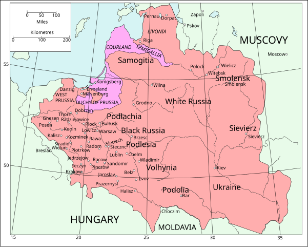
English: Map of Poland and Lithuania following the Union of Lublin in 1569.
|
||
| Dato | (UTC) | ||
| Kilde | Map of Poland and Lithuania after the Union of Lublin (1569).jpg | ||
| Forfatter |
|
||
| SVG udvikling | Vektorgrafikken blev lavet med Inkscape.
.
|
.jpg)
Denne fil er udgivet under Creative Commons Kreditering-Del på samme vilkår 3.0 Ikke-porteret-licensen.
- Du må frit:
- at dele – at kopiere, distribuere og overføre værket
- at remixe – at tilpasse værket
- Under følgende vilkår:
- kreditering – Du skal give passende kreditering, angive et link til licensen, og oplyse om der er foretaget ændringer. Du må gøre det på enhver fornuftig måde, men ikke på en måde der antyder at licensgiveren godkender dig eller din anvendelse.
- deling på samme vilkår – Hvis du bearbejder, ændrer eller bygger videre på dette værk, skal du distribuere dine bidrag under den samme eller en kompatibel licens som originalen.
| File | Type | Details |
|---|---|---|
| File:Polish-Lithuania map (1450-1600).svg | Large SVG | Map showing conflicts and territorial changes on the Polish-Lithuanian—Russian border, 1450–1600 |
| File:Duchy of Prussia.svg | Small SVG | Map of the Duchy of Prussia |
| File:Livonian war map (1558-1560).svg | Small SVG | Map showing campaigns in Livonia, 1558–1560. |
| File:Map of Poland and Lithuania after the Union of Lublin (1569).svg | Large SVG | Map of the w:Polish-Lithuanian Commonwealth after the Union of Lublin in 1569. |
| File:Livonian war map (1570-1577).svg | Small SVG | Map showing areas of Russian and Polish-Lithuanian forces, 1570–1577. |
| File:Campaigns of Stefan Batory.svg | Small SVG | Map of the campaign of Stefan Batory in Livonia (1575–1580). |
| File:Map of Poland and Lithuania in 1600.svg | Small SVG | Map of Livonia in 1600 |
| See also: User:Halibutt/maps, by Halibutt (diskussion · bidrag). | ||
.svg)
.svg)
.svg)
.svg)
Oprindelig oplægningslog
This image is a derivative work of the following images:
- Map of Poland and Lithuania after the Union of Lublin (1569).jpg licensed with PD-1923, PD-UK-unknown
- 2011-04-12T13:13:53Z Grandiose 1660x1027 (1008090 Bytes) Improve colouring.
- 2011-04-12T12:58:38Z Grandiose 1660x1027 (402170 Bytes) {{Information |Description ={{en|1=Map of Poland and Lithuania following the Union of Lublin in 1569. Taken from "The Cambridge Modern History Atlas", 1912, London: Cambridge University Press. Editors were Sir Adolphus W
Filhistorik
Klik på en dato/tid for at se filen som den så ud på det tidspunkt.
| Dato/tid | Miniaturebillede | Dimensioner | Bruger | Kommentar | |
|---|---|---|---|---|---|
| nuværende | 9. maj 2011, 18:44 | | 1.205 × 963 (116 KB) | Grandiose | Done my best on the Swedish coastline |
| 14. apr. 2011, 12:29 |  | 1.205 × 963 (116 KB) | Grandiose | A couple more places, Duchy statuses. | |
| 13. apr. 2011, 19:05 |  | 1.205 × 963 (117 KB) | Grandiose | {{Information |Description={{en|1=Map of Poland and Lithuania following the Union of Lublin in 1569. Adapted from "The Cambridge Modern History Atlas", 1912, London: Cambridge University Press. (See source file for more information.)}} |Source=*[[:File:M |
Filanvendelse
Der er ingen sider der bruger denne fil.
Global filanvendelse
Følgende andre wikier anvender denne fil:
- Anvendelser på ca.wikipedia.org
- Anvendelser på de.wikipedia.org
- Anvendelser på fr.wikipedia.org
- Anvendelser på uk.wikipedia.org
.svg)