Fil:Safe trail map NPS1962.jpg

Størrelse af denne forhåndsvisning: 800 × 532 pixels. Andre opløsninger: 320 × 213 pixels | 640 × 426 pixels | 900 × 599 pixels.
Fuld opløsning (900 × 599 billedpunkter, filstørrelse: 48 KB, MIME-type: image/jpeg)
|
|
Denne fil er fra Wikimedia Commons. Beskrivelsen af filen fra Commons er gengivet nedenfor. |
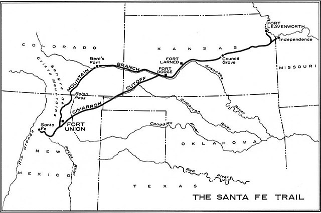
| Beskrivelse | Map of the historic Santa Fe Trail in the southwestern United States as around 1860 | |||
| Dato | ||||
| Kilde | http://www.cr.nps.gov/history/online_books/hh/35/images/hh35b1.jpg - from Robert M. Utley, FORT UNION - National Monument - New Mexico, National Park Service, Historical Handbook Series No. 35, Washington, D.C., 1962 | |||
| Forfatter | NPS Graphics | |||
| Tilladelse (Genbrug af denne fil) |
|
Filhistorik
Klik på en dato/tid for at se filen som den så ud på det tidspunkt.
| Dato/tid | Miniaturebillede | Dimensioner | Bruger | Kommentar | |
|---|---|---|---|---|---|
| nuværende | 20. okt. 2006, 10:38 | | 900 × 599 (48 KB) | H-stt | {{Information |Description= Map of the historic ''Santa Fe Trail'' in the southwestern United States as around 1860 |Source= http://www.cr.nps.gov/history/online_books/hh/35/images/hh35b1.jpg - from Robert M. Utley, ''FORT UNION - National Monument - New |
Filanvendelse
Den følgende side bruger denne fil:
Global filanvendelse
Følgende andre wikier anvender denne fil:
- Anvendelser på de.wikipedia.org
- Anvendelser på en.wikipedia.org
- Anvendelser på es.wikipedia.org
- Anvendelser på fa.wikipedia.org
- Anvendelser på it.wikipedia.org
- Anvendelser på no.wikipedia.org
- Anvendelser på sr.wikipedia.org
- Anvendelser på sv.wikipedia.org
- Anvendelser på www.wikidata.org