| billede
|
Navn
|
beliggende i det administrative område
|
geografiske koordinater
|
Commons-kategori
|
|
|
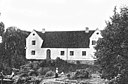
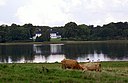
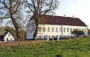
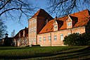
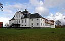
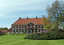
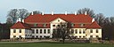
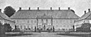
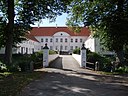
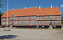
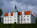
Aalegaard
|
Jammerbugt Kommune
|
57°04′48″N 9°19′39″Ø / 57.08°N 9.32752°Ø / 57.08; 9.32752
|
|

|
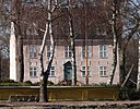
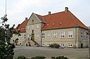
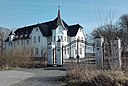
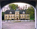
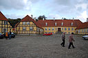
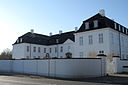
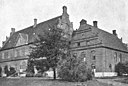
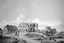
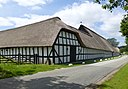
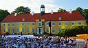
Aalholm
|
Guldborgsund Kommune
|
54°39′52″N 11°43′25″Ø / 54.664444444444°N 11.723611111111°Ø / 54.664444444444; 11.723611111111
|
Aalholm (Lolland)
|
|
|
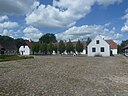
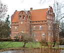
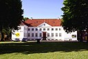
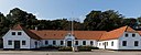
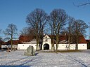
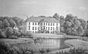
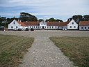
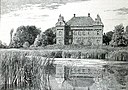
Aalstrup
|
Lolland Kommune
|
54°46′14″N 11°18′08″Ø / 54.77048°N 11.30212°Ø / 54.77048; 11.30212
|
Ålstrup
|

|
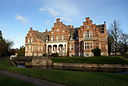
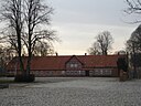
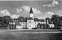
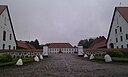
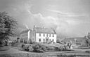
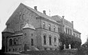
Aastrup
|
Lejre Kommune
|
55°37′14″N 11°48′11″Ø / 55.6205°N 11.803°Ø / 55.6205; 11.803
|
Aastrup (Soderup Sogn)
|
|
|
Agdrup
|
Aalborg Kommune
|
57°07′03″N 9°59′06″Ø / 57.1175°N 9.98492°Ø / 57.1175; 9.98492
|
|
|
|
Agernæsgård
|
Nordfyns Kommune
|
55°35′18″N 10°21′28″Ø / 55.5882°N 10.3579°Ø / 55.5882; 10.3579
|
|
|
|
Agersbøl
|
Hedensted Kommune
|
55°47′29″N 9°35′49″Ø / 55.7914°N 9.59694°Ø / 55.7914; 9.59694
|
|
|
|
Agerupgård
|
Guldborgsund Kommune
|
54°46′58″N 11°36′25″Ø / 54.7828°N 11.6069°Ø / 54.7828; 11.6069
|
|

|
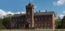
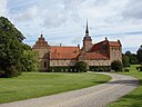
Aggersborggård
|
Vesthimmerlands Kommune
|
56°59′38″N 9°15′19″Ø / 56.99397°N 9.25531°Ø / 56.99397; 9.25531
|
Aggersborggård
|

|
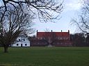
Aggersvold
|
Holbæk Kommune
|
55°41′21″N 11°25′41″Ø / 55.6891°N 11.4281°Ø / 55.6891; 11.4281
|
Aggersvold
|
|
|
Albæk
|
Rebild Kommune
|
56°51′08″N 9°44′08″Ø / 56.8522°N 9.73556°Ø / 56.8522; 9.73556
|
|
|
|
Algestrup
|
Kalundborg Kommune
|
55°43′21″N 11°19′12″Ø / 55.7225°N 11.3201°Ø / 55.7225; 11.3201
|
|
|
|
Alleenborg
|
Lolland Kommune
|
54°56′00″N 11°09′41″Ø / 54.9333°N 11.1614°Ø / 54.9333; 11.1614
|
|
|
|
Allindemaglegård
|
Ringsted Kommune
|
55°30′22″N 11°43′30″Ø / 55.5061°N 11.7251°Ø / 55.5061; 11.7251
|
|

|
Alling Skovgård
|
Silkeborg Kommune
|
56°15′28″N 9°36′22″Ø / 56.2578°N 9.60611°Ø / 56.2578; 9.60611
|
|
|
|
Allinggård
|
Silkeborg Kommune
|
56°16′07″N 9°38′00″Ø / 56.2686°N 9.63333°Ø / 56.2686; 9.63333
|
|
|
|
Alslevgård
|
Faxe Kommune
|
55°17′02″N 12°10′40″Ø / 55.2838°N 12.1777°Ø / 55.2838; 12.1777
|
|
|
|
Amdrupgård
|
Favrskov Kommune
|
56°18′13″N 10°07′39″Ø / 56.303691666667°N 10.127505555556°Ø / 56.303691666667; 10.127505555556
|
|
|
|
Anhof
|
Nyborg Kommune
|
55°13′13″N 10°43′32″Ø / 55.220277777778°N 10.725555555556°Ø / 55.220277777778; 10.725555555556
|
|

|
Anneberg
|
Odsherred Kommune
|
55°54′08″N 11°39′59″Ø / 55.90219°N 11.66645°Ø / 55.90219; 11.66645
|
Anneberg Hovedgård
|
|
|
Antvorskov
|
Slagelse Kommune
|
55°23′29″N 11°21′50″Ø / 55.3915°N 11.3639°Ø / 55.3915; 11.3639
|
|

|
Arnakkegård
|
Holbæk Kommune
|
55°43′25″N 11°25′29″Ø / 55.72361111111111°N 11.424722222222222°Ø / 55.72361111111111; 11.424722222222222
|
|
|
Arreskov
|
Faaborg-Midtfyn Kommune
|
55°09′51″N 10°18′53″Ø / 55.16425°N 10.31485°Ø / 55.16425; 10.31485
|
Arreskov
|

|
Arresødal
|
Halsnæs Kommune
|
55°58′37″N 12°01′57″Ø / 55.976944444444°N 12.0325°Ø / 55.976944444444; 12.0325
|
Arresødal
|

|
Asdal Hovedgård
|
Hjørring Kommune
|
57°33′20″N 10°01′41″Ø / 57.55569°N 10.02807°Ø / 57.55569; 10.02807
|
Asdal Hovedgård
|
|
|
Asmild Kloster
|
Viborg Kommune
|
56°26′49″N 9°25′30″Ø / 56.44694444°N 9.425°Ø / 56.44694444; 9.425
|
|
|
|
Asnæsgård
|
Kalundborg Kommune
|
55°39′45″N 10°57′22″Ø / 55.6626°N 10.9562°Ø / 55.6626; 10.9562
|
|
|
|
Assendrup
|
Næstved Kommune
|
55°20′01″N 11°50′44″Ø / 55.3337°N 11.8456°Ø / 55.3337; 11.8456
|
|
|
|
Asserstrup
|
Lolland Kommune
|
54°52′54″N 11°06′44″Ø / 54.8817°N 11.1122°Ø / 54.8817; 11.1122
|
|
|
|
Astrup
|
Skive Kommune
|
56°40′31″N 9°05′41″Ø / 56.6752°N 9.0947°Ø / 56.6752; 9.0947
|
|

|
Astrup Gods
|
Kalundborg Kommune
|
55°39′05″N 11°21′20″Ø / 55.6514°N 11.3556°Ø / 55.6514; 11.3556
|
Astrup Gods
|
|
|
Attrup
|
Aalborg Kommune
|
57°07′02″N 10°02′55″Ø / 57.1172°N 10.0486°Ø / 57.1172; 10.0486
|
|

|
Aunsbjerg
|
Silkeborg Kommune
|
56°19′17″N 9°24′57″Ø / 56.3214°N 9.4159°Ø / 56.3214; 9.4159
|
Aunsbjerg
|
|
|
Aunsøgård
|
Kalundborg Kommune
|
55°38′39″N 11°19′27″Ø / 55.6441°N 11.3241°Ø / 55.6441; 11.3241
|
|

|
Ausumgård
|
Struer Kommune
|
56°25′45″N 8°36′03″Ø / 56.4291°N 8.6007°Ø / 56.4291; 8.6007
|
Ausumgård
|
|
|
Avnøgård
|
Vordingborg Kommune
|
55°05′19″N 11°46′03″Ø / 55.0886°N 11.7675°Ø / 55.0886; 11.7675
|
|
|
Baggesvogn
|
Hjørring Kommune
|
57°30′21″N 10°08′46″Ø / 57.5058°N 10.1462°Ø / 57.5058; 10.1462
|
Baggesvogn
|

|
Ballegård
|
Sønderborg Kommune
|
54°59′40″N 9°40′10″Ø / 54.99451°N 9.66952°Ø / 54.99451; 9.66952
|
Ballegård
|

|
Bangsbo Hovedgård
|
Frederikshavn Kommune
|
57°25′13″N 10°30′15″Ø / 57.42022°N 10.50429°Ø / 57.42022; 10.50429
|
Bangsbo Herregård
|
|
|
Bannerslund
|
Frederikshavn Kommune
|
57°28′56″N 10°28′46″Ø / 57.4822°N 10.4794°Ø / 57.4822; 10.4794
|
|
|
|
Barfredshøj
|
Ishøj Kommune
|
55°37′19″N 12°13′21″Ø / 55.622°N 12.2224°Ø / 55.622; 12.2224
|
|

|
Barløsegård
|
Assens Kommune
|
55°20′00″N 9°58′09″Ø / 55.3333°N 9.96917°Ø / 55.3333; 9.96917
|
|

|
Barritskov
|
Hedensted Kommune
|
55°42′22″N 9°55′02″Ø / 55.706°N 9.91722°Ø / 55.706; 9.91722
|
|
|
Basnæs
|
Slagelse Kommune
|
55°12′37″N 11°20′43″Ø / 55.2102°N 11.3452°Ø / 55.2102; 11.3452
|
Basnæs
|
|
|
Bavelse
|
Næstved Kommune
|
55°20′10″N 11°38′39″Ø / 55.3362°N 11.6443°Ø / 55.3362; 11.6443
|
Bavelse
|
|
Bedholm
|
Jammerbugt Kommune
|
57°10′41″N 9°42′03″Ø / 57.178°N 9.7007°Ø / 57.178; 9.7007
|
|

|
Beldringe
|
Vordingborg Kommune
|
55°06′26″N 11°59′28″Ø / 55.1071°N 11.9912°Ø / 55.1071; 11.9912
|
Beldringe Gods
|

|
Benzonsdal
|
Ishøj Kommune
|
55°37′22″N 12°15′20″Ø / 55.6229°N 12.2555°Ø / 55.6229; 12.2555
|
Benzonsdal
|

|
Berritzgård
|
Guldborgsund Kommune
|
54°49′17″N 11°39′56″Ø / 54.82138889°N 11.66555556°Ø / 54.82138889; 11.66555556
|
|

|
Bidstrup
|
Favrskov Kommune
|
56°20′52″N 9°56′05″Ø / 56.34784°N 9.93478°Ø / 56.34784; 9.93478
|
Bidstrup
|

|
Billesborg
|
Køge Kommune
|
55°25′40″N 12°11′59″Ø / 55.4279°N 12.1996°Ø / 55.4279; 12.1996
|
|
|
|
Billeshave
|
Middelfart Kommune
|
55°32′10″N 9°48′10″Ø / 55.5361°N 9.80278°Ø / 55.5361; 9.80278
|
|
|
Billeskov
|
Assens Kommune
|
55°20′51″N 9°57′04″Ø / 55.3475°N 9.95111°Ø / 55.3475; 9.95111
|
Billeskov
|
|
|
Binnitze
|
Lolland Kommune
|
54°44′26″N 11°27′14″Ø / 54.7406°N 11.4539°Ø / 54.7406; 11.4539
|
|

|
Birkelse Hovedgård
|
Jammerbugt Kommune
|
57°08′59″N 9°42′13″Ø / 57.1497°N 9.7035°Ø / 57.1497; 9.7035
|
Birkelse Hovedgård
|
|
Birkendegård
|
Kalundborg Kommune
|
55°40′25″N 11°12′26″Ø / 55.6736°N 11.2071°Ø / 55.6736; 11.2071
|
Birkendegård
|
|
|
Birkumgård
|
Jammerbugt Kommune
|
57°04′24″N 9°44′10″Ø / 57.0733°N 9.73611°Ø / 57.0733; 9.73611
|
|
|
|
Bisgård
|
Samsø Kommune
|
55°51′39″N 10°35′10″Ø / 55.8608°N 10.5861°Ø / 55.8608; 10.5861
|
|

|
Biskopstorp
|
Nyborg Kommune
|
55°19′55″N 10°40′13″Ø / 55.3319°N 10.6703°Ø / 55.3319; 10.6703
|
|

|
Bjergbygård
|
Holbæk Kommune
|
55°40′31″N 11°28′48″Ø / 55.6752°N 11.4799°Ø / 55.6752; 11.4799
|
|

|
Bjørnemose
|
Svendborg Kommune
|
55°03′33″N 10°39′37″Ø / 55.0592°N 10.6603°Ø / 55.0592; 10.6603
|
|
|
|
Bjørnholm
|
Syddjurs Kommune
|
56°20′03″N 10°43′26″Ø / 56.3342°N 10.7239°Ø / 56.3342; 10.7239
|
|
|
|
Bjørnkær
|
Jammerbugt Kommune
|
57°08′23″N 9°49′27″Ø / 57.1397°N 9.82417°Ø / 57.1397; 9.82417
|
|
|
|
Bjørum
|
Aalborg Kommune
|
57°07′22″N 9°55′24″Ø / 57.1228°N 9.92333°Ø / 57.1228; 9.92333
|
|

|
Blangstedgaard
|
Odense Kommune
|
55°22′53″N 10°26′40″Ø / 55.38137°N 10.44445°Ø / 55.38137; 10.44445
|
Blangstedgaard
|
|
|
Blidstrup
|
Morsø Kommune
|
56°42′55″N 8°41′33″Ø / 56.7154°N 8.69244°Ø / 56.7154; 8.69244
|
|

|
Blågård
|
Københavns Kommune
|
|
Blågård Slot
|

|
Boller
|
Horsens Kommune
|
55°50′16″N 9°53′48″Ø / 55.8378°N 9.8968°Ø / 55.8378; 9.8968
|
Boller
|
|
|
Boller
|
Viborg Kommune
|
56°29′25″N 9°16′46″Ø / 56.4903°N 9.27944°Ø / 56.4903; 9.27944
|
|
|
|
Boller
|
Hjørring Kommune
|
57°23′03″N 10°05′40″Ø / 57.3842°N 10.0944°Ø / 57.3842; 10.0944
|
|

|
Boltinggård
|
Faaborg-Midtfyn Kommune
|
55°12′56″N 10°26′57″Ø / 55.2156°N 10.4492°Ø / 55.2156; 10.4492
|
|

|
Bonderup
|
Holbæk Kommune
|
55°34′03″N 11°41′12″Ø / 55.5676°N 11.6866°Ø / 55.5676; 11.6866
|
Bonderup (Store Tåstrup Sogn)
|
|
|
Borupgård
|
Helsingør Kommune
|
56°00′42″N 12°34′55″Ø / 56.0118°N 12.5819°Ø / 56.0118; 12.5819
|
|

|
Brahesborg
|
Assens Kommune
|
55°16′49″N 9°57′06″Ø / 55.2803°N 9.95167°Ø / 55.2803; 9.95167
|
Brahesborg
|
|
|
Brahesholm
|
Assens Kommune
|
55°18′44″N 10°03′08″Ø / 55.3122°N 10.0522°Ø / 55.3122; 10.0522
|
|
|
Bramming Hovedgård
|
Esbjerg Kommune
|
55°29′10″N 8°41′49″Ø / 55.4861°N 8.6969°Ø / 55.4861; 8.6969
|
Bramming Hovedgård
|
|
Bramsløkke
|
Guldborgsund Kommune
|
54°43′46″N 11°39′37″Ø / 54.72957°N 11.6604°Ø / 54.72957; 11.6604
|
Bramsløkke
|

|
Bramstrup
|
Faaborg-Midtfyn Kommune
|
55°19′18″N 10°23′52″Ø / 55.3217°N 10.3978°Ø / 55.3217; 10.3978
|
|
|
Brandbjerg
|
Vejle Kommune
|
55°46′15″N 9°28′18″Ø / 55.7708°N 9.47167°Ø / 55.7708; 9.47167
|
Brandbjerg Herregård
|

|
Bratskov
|
Jammerbugt Kommune
|
57°06′06″N 9°31′08″Ø / 57.1018°N 9.5189°Ø / 57.1018; 9.5189
|
Bratskov
|

|
Brattingsborg
|
Samsø Kommune
|
55°47′02″N 10°35′09″Ø / 55.78388889°N 10.58583333°Ø / 55.78388889; 10.58583333
|
Brattingsborg
|
|
|
Bredeshave
|
Næstved Kommune
|
55°09′20″N 12°00′50″Ø / 55.1556°N 12.0139°Ø / 55.1556; 12.0139
|
|

|
Bregentved
|
Faxe Kommune
|
55°18′27″N 12°00′25″Ø / 55.3074°N 12.007°Ø / 55.3074; 12.007
|
Bregentved
|
|
|
Bregnholm
|
Hedensted Kommune
|
55°53′43″N 9°34′08″Ø / 55.8953°N 9.56889°Ø / 55.8953; 9.56889
|
|

|
Brejninggård
|
Ringkøbing-Skjern Kommune
|
56°06′55″N 8°30′47″Ø / 56.11539°N 8.51301°Ø / 56.11539; 8.51301
|
Brejninggård
|
|
|
Bremersvold
|
Lolland Kommune
|
54°40′53″N 11°31′29″Ø / 54.6814°N 11.5248°Ø / 54.6814; 11.5248
|
|
|
Brobygård
|
Faaborg-Midtfyn Kommune
|
55°13′44″N 10°16′09″Ø / 55.2289°N 10.2692°Ø / 55.2289; 10.2692
|
|
|
Brockdorff
|
Kerteminde Kommune
|
55°34′06″N 10°38′26″Ø / 55.5683°N 10.6406°Ø / 55.5683; 10.6406
|
|

|
Broholm
|
Svendborg Kommune
|
55°08′13″N 10°43′40″Ø / 55.13694444°N 10.72777778°Ø / 55.13694444; 10.72777778
|
Broholm
|
|
|
Broksø
|
Næstved Kommune
|
55°18′22″N 11°50′05″Ø / 55.3061°N 11.8348°Ø / 55.3061; 11.8348
|
Broksø
|

|
Broløkke
|
Langeland Kommune
|
54°46′09″N 10°43′18″Ø / 54.769064330346°N 10.721795258224°Ø / 54.769064330346; 10.721795258224
|
Broløkke (Langeland)
|

|
Broløkke
|
Kerteminde Kommune
|
55°28′30″N 10°40′44″Ø / 55.475°N 10.6789°Ø / 55.475; 10.6789
|
|
|
|
Brorupgaard
|
Slagelse Kommune
|
55°26′21″N 11°19′11″Ø / 55.4391°N 11.3197°Ø / 55.4391; 11.3197
|
|

|
Brændegård
|
Faaborg-Midtfyn Kommune
|
55°07′33″N 10°23′29″Ø / 55.1258°N 10.3914°Ø / 55.1258; 10.3914
|
|
|
|
Brøndum Hovedgård
|
Vesthimmerlands Kommune
|
56°57′53″N 9°21′58″Ø / 56.9648°N 9.36606°Ø / 56.9648; 9.36606
|
|

|
Buderupholm
|
Rebild Kommune
|
56°51′31″N 9°51′22″Ø / 56.8587°N 9.8562°Ø / 56.8587; 9.8562
|
Buderupholm
|
|
|
Burholt
|
Brønderslev Kommune
|
57°15′05″N 9°59′16″Ø / 57.2514°N 9.98778°Ø / 57.2514; 9.98778
|
|

|
Buskmosegård
|
Sønderborg Kommune
|
54°54′33″N 9°32′04″Ø / 54.90917°N 9.53432°Ø / 54.90917; 9.53432
|
Hof Buskmose
|
|
|
Buskysminde
|
Kalundborg Kommune
|
55°31′50″N 11°22′30″Ø / 55.5306°N 11.3749°Ø / 55.5306; 11.3749
|
|
|
|
Bustrup
|
Skive Kommune
|
56°35′06″N 8°48′41″Ø / 56.585°N 8.81139°Ø / 56.585; 8.81139
|
Bustrup
|

|
Bygholm
|
Horsens Kommune
|
55°51′53″N 9°49′32″Ø / 55.864722222222°N 9.8255555555556°Ø / 55.864722222222; 9.8255555555556
|
Bygholm
|
|
|
Bådesgård
|
Lolland Kommune
|
54°46′13″N 11°13′34″Ø / 54.7703°N 11.2261°Ø / 54.7703; 11.2261
|
|

|
Bækkeskov
|
Næstved Kommune
|
55°11′27″N 12°00′53″Ø / 55.1907°N 12.0148°Ø / 55.1907; 12.0148
|
|
|
|
Bødstrup
|
Kalundborg Kommune
|
55°28′30″N 11°13′38″Ø / 55.4751°N 11.2273°Ø / 55.4751; 11.2273
|
|

|
Bøgebjerg
|
Kerteminde Kommune
|
55°32′34″N 10°41′16″Ø / 55.542777777778°N 10.687777777778°Ø / 55.542777777778; 10.687777777778
|
|
|
|
Bøgsted
|
Hjørring Kommune
|
57°28′16″N 10°06′12″Ø / 57.4711°N 10.1032°Ø / 57.4711; 10.1032
|
|

|
Børglum Kloster
|
Hjørring Kommune
|
57°22′08″N 9°47′57″Ø / 57.36888889°N 9.79916667°Ø / 57.36888889; 9.79916667
|
Børglum Kloster
|
|
|
Cathrinebjerg
|
Middelfart Kommune
|
55°32′35″N 9°49′16″Ø / 55.5431°N 9.82111°Ø / 55.5431; 9.82111
|
|
|
|
Charlottendal
|
Slagelse Kommune
|
55°22′53″N 11°22′56″Ø / 55.38147°N 11.38224°Ø / 55.38147; 11.38224
|
|
|
|
Charlottenlund
|
Langeland Kommune
|
55°08′56″N 10°55′32″Ø / 55.1489°N 10.9256°Ø / 55.1489; 10.9256
|
|
|
|
Christiansdal
|
Lolland Kommune
|
54°51′16″N 11°08′25″Ø / 54.8544°N 11.1403°Ø / 54.8544; 11.1403
|
|
|
|
Christiansdal
|
Hjørring Kommune
|
57°23′14″N 9°49′43″Ø / 57.3873°N 9.8286°Ø / 57.3873; 9.8286
|
|
|
|
Christianslund
|
Randers Kommune
|
56°24′07″N 9°58′25″Ø / 56.4019°N 9.97361°Ø / 56.4019; 9.97361
|
|

|
Christianssæde
|
Lolland Kommune
|
54°45′28″N 11°21′13″Ø / 54.7578°N 11.3537°Ø / 54.7578; 11.3537
|
Christianssæde
|

|
Christinelund
|
Vordingborg Kommune
|
55°07′09″N 12°04′30″Ø / 55.1191°N 12.0751°Ø / 55.1191; 12.0751
|
Christinelund
|

|
Clausholm
|
Favrskov Kommune
|
56°23′05″N 10°10′13″Ø / 56.38472222°N 10.17013889°Ø / 56.38472222; 10.17013889
|
Clausholm Slot
|

|
Constantinsborg
|
Aarhus Kommune
|
56°08′22″N 10°04′36″Ø / 56.13946°N 10.07655°Ø / 56.13946; 10.07655
|
Constantinsborg
|

|
Corselitze
|
Guldborgsund Kommune
|
54°46′05″N 12°01′12″Ø / 54.768°N 12.0201°Ø / 54.768; 12.0201
|
Corselitze
|
|
|
Dalbyegaard
|
Guldborgsund Kommune
|
54°50′47″N 12°00′41″Ø / 54.8464°N 12.0114°Ø / 54.8464; 12.0114
|
|
|
Dallund
|
Nordfyns Kommune
|
55°29′06″N 10°16′46″Ø / 55.4851°N 10.2794°Ø / 55.4851; 10.2794
|
Dallund Slot
|
|
|
Dalsgaard
|
Mariagerfjord Kommune
|
56°42′34″N 10°05′24″Ø / 56.7094°N 10.09°Ø / 56.7094; 10.09
|
|

|
Dalum Kloster
|
Odense Kommune
|
55°21′48″N 10°22′27″Ø / 55.36338°N 10.37404°Ø / 55.36338; 10.37404
|
Dalum Kloster
|

|
Damsbo
|
Assens Kommune
|
55°11′01″N 10°08′33″Ø / 55.1836°N 10.1425°Ø / 55.1836; 10.1425
|
|
|
|
Dansted
|
Lolland Kommune
|
54°43′48″N 11°23′25″Ø / 54.73°N 11.3903°Ø / 54.73; 11.3903
|
|
|
|
Davrup
|
Kalundborg Kommune
|
55°40′56″N 11°20′41″Ø / 55.6823°N 11.3447°Ø / 55.6823; 11.3447
|
|
|
|
Demstrup
|
Randers Kommune
|
56°37′27″N 10°15′03″Ø / 56.6241°N 10.2508°Ø / 56.6241; 10.2508
|
|
|
|
Diget
|
Nordfyns Kommune
|
55°27′38″N 10°04′47″Ø / 55.4606°N 10.0797°Ø / 55.4606; 10.0797
|
|
|
|
Dragsgård
|
Rebild Kommune
|
56°50′06″N 10°09′00″Ø / 56.835°N 10.15°Ø / 56.835; 10.15
|
|
|
|
Drenderupgård
|
Kolding Kommune
|
55°24′25″N 9°21′02″Ø / 55.4069°N 9.35056°Ø / 55.4069; 9.35056
|
|

|
Dronningborg
|
Randers Kommune
|
56°28′55″N 10°04′21″Ø / 56.482°N 10.0725°Ø / 56.482; 10.0725
|
Dronningborg (gods)
|

|
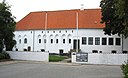
Dronninglund Slot
|
Brønderslev Kommune
|
57°09′19″N 10°15′42″Ø / 57.1553°N 10.2617°Ø / 57.1553; 10.2617
|
Dronninglund Slot
|
|
Dueholm Kloster
|
Morsø Kommune
|
56°47′39″N 8°51′10″Ø / 56.79429°N 8.85285°Ø / 56.79429; 8.85285
|
Dueholm Kloster
|

|
Dybvad Gods
|
Odder Kommune
|
55°55′06″N 10°09′45″Ø / 55.9183°N 10.1625°Ø / 55.9183; 10.1625
|
|
|
|
Dybvad Hovedgård
|
Frederikshavn Kommune
|
57°16′43″N 10°21′32″Ø / 57.2787°N 10.359°Ø / 57.2787; 10.359
|
|

|
Dyrehavegård
|
Kolding Kommune
|
55°29′52″N 9°29′01″Ø / 55.4978°N 9.48361°Ø / 55.4978; 9.48361
|
|
|
|
Dønnerup
|
Holbæk Kommune
|
55°37′16″N 11°25′07″Ø / 55.621°N 11.4187°Ø / 55.621; 11.4187
|
|

|
Edelgave
|
Egedal Kommune
|
55°43′31″N 12°15′27″Ø / 55.72538°N 12.25737°Ø / 55.72538; 12.25737
|
Edelgave
|
|
|
Egebaksande
|
Thisted Kommune
|
56°56′58″N 8°27′55″Ø / 56.9494°N 8.46528°Ø / 56.9494; 8.46528
|
|
|
|
Egebjerg
|
Hjørring Kommune
|
57°26′21″N 10°07′33″Ø / 57.4392°N 10.1258°Ø / 57.4392; 10.1258
|
|
|
Egebjerggård
|
Nordfyns Kommune
|
55°36′08″N 10°20′57″Ø / 55.6021°N 10.3491°Ø / 55.6021; 10.3491
|
Egebjerggård (Fyn)
|

|
Egeløkke
|
Langeland Kommune
|
55°02′39″N 10°51′32″Ø / 55.0442°N 10.8589°Ø / 55.0442; 10.8589
|
Egeløkke
|

|
Egemarke
|
Kalundborg Kommune
|
55°44′05″N 11°21′55″Ø / 55.7348°N 11.3653°Ø / 55.7348; 11.3653
|
Egemarke
|
|
|
Egensekloster
|
Aalborg Kommune
|
56°57′51″N 10°14′59″Ø / 56.9642°N 10.2497°Ø / 56.9642; 10.2497
|
|
|
|
Eget
|
Frederikshavn Kommune
|
57°24′01″N 10°20′40″Ø / 57.4003°N 10.3444°Ø / 57.4003; 10.3444
|
|
|
|
Egholm
|
Guldborgsund Kommune
|
54°39′42″N 11°38′58″Ø / 54.6618°N 11.6495°Ø / 54.6618; 11.6495
|
|

|
Egholm
|
Lejre Kommune
|
55°43′58″N 11°54′45″Ø / 55.7328°N 11.9125°Ø / 55.7328; 11.9125
|
Egholm Slot
|
|
|
Ellingegård
|
Odsherred Kommune
|
55°53′42″N 11°34′21″Ø / 55.8951°N 11.5725°Ø / 55.8951; 11.5725
|
|
|
|
Ellinggård
|
Frederikshavn Kommune
|
57°28′11″N 10°28′06″Ø / 57.4697°N 10.4683°Ø / 57.4697; 10.4683
|
|
|
|
Elsnab
|
Aalborg Kommune
|
57°03′57″N 10°14′31″Ø / 57.0658°N 10.2419°Ø / 57.0658; 10.2419
|
|

|
Elvedgård
|
Nordfyns Kommune
|
55°28′30″N 10°07′56″Ø / 55.475°N 10.1322°Ø / 55.475; 10.1322
|
|
|
|
Endrupholm
|
Esbjerg Kommune
|
55°31′13″N 8°43′02″Ø / 55.520277777778°N 8.7172222222222°Ø / 55.520277777778; 8.7172222222222
|
|

|
Engelholm
|
Næstved Kommune
|
55°08′28″N 11°58′56″Ø / 55.1412°N 11.9823°Ø / 55.1412; 11.9823
|
Engelholm Gods
|

|
Engelsholm Slot
|
Vejle Kommune
|
55°42′57″N 9°19′05″Ø / 55.7159°N 9.318°Ø / 55.7159; 9.318
|
Engelsholm Slot
|
|
Engestofte
|
Guldborgsund Kommune
|
54°45′44″N 11°33′44″Ø / 54.7623°N 11.5621°Ø / 54.7623; 11.5621
|
Engestofte
|
|
|
Engholm
|
Aalborg Kommune
|
57°05′38″N 9°59′53″Ø / 57.0939°N 9.99806°Ø / 57.0939; 9.99806
|
|
|
Erholm
|
Assens Kommune
|
55°23′46″N 10°02′56″Ø / 55.396°N 10.0489°Ø / 55.396; 10.0489
|
Erholm
|
|
Eriksholm
|
Holbæk Kommune
|
55°40′55″N 11°47′36″Ø / 55.681875°N 11.79333056°Ø / 55.681875; 11.79333056
|
Eriksholm Slot
|
|
|
Eskilstrup
|
Ringsted Kommune
|
55°22′37″N 11°52′48″Ø / 55.3769°N 11.88°Ø / 55.3769; 11.88
|
|
|
|
Eskjær
|
Skive Kommune
|
56°41′39″N 9°06′50″Ø / 56.6941°N 9.114°Ø / 56.6941; 9.114
|
|

|
Eskær
|
Hjørring Kommune
|
57°30′35″N 10°17′05″Ø / 57.5096°N 10.2848°Ø / 57.5096; 10.2848
|
|
|
|
Espe Hovedgård
|
Slagelse Kommune
|
55°17′30″N 11°14′39″Ø / 55.2917°N 11.2442°Ø / 55.2917; 11.2442
|
|
|
|
Estrup
|
Vejen Kommune
|
55°29′39″N 9°03′39″Ø / 55.4942°N 9.06083°Ø / 55.4942; 9.06083
|
|

|
Estruplund
|
Norddjurs Kommune
|
56°33′08″N 10°21′35″Ø / 56.5522°N 10.3597°Ø / 56.5522; 10.3597
|
|
|
|
Estvadgård
|
Skive Kommune
|
56°31′51″N 8°58′44″Ø / 56.5308°N 8.97889°Ø / 56.5308; 8.97889
|
|
|
|
Falkenhøj
|
Kalundborg Kommune
|
55°33′16″N 11°20′07″Ø / 55.5545°N 11.3354°Ø / 55.5545; 11.3354
|
|

|
Falkensteen
|
Slagelse Kommune
|
55°21′27″N 11°22′01″Ø / 55.3576°N 11.3669°Ø / 55.3576; 11.3669
|
Falkensteen
|

|
Farumgård
|
Furesø Kommune
|
55°48′22″N 12°21′39″Ø / 55.805983333333°N 12.360733333333°Ø / 55.805983333333; 12.360733333333
|
Farumgård
|

|
Favrholm
|
Hillerød Kommune
|
55°54′29″N 12°17′05″Ø / 55.9081°N 12.2848°Ø / 55.9081; 12.2848
|
Favrholm Campus
|
|
Favrskov
|
Favrskov Kommune
|
56°20′10″N 9°59′27″Ø / 56.3361°N 9.99083°Ø / 56.3361; 9.99083
|
|

|
Fjeld
|
Syddjurs Kommune
|
56°23′43″N 10°25′52″Ø / 56.39519°N 10.43099°Ø / 56.39519; 10.43099
|
Fjeld (Djursland)
|
|
Fjellerup Østergård
|
Lyngby-Taarbæk Kommune
|
55°47′32″N 12°29′46″Ø / 55.792278197986°N 12.496224044412°Ø / 55.792278197986; 12.496224044412
|
Herregården
|

|
Fjællebro
|
Faaborg-Midtfyn Kommune
|
55°11′19″N 10°27′16″Ø / 55.1886°N 10.4544°Ø / 55.1886; 10.4544
|
|

|
Flenstofte
|
Assens Kommune
|
55°12′50″N 9°59′54″Ø / 55.2139°N 9.99833°Ø / 55.2139; 9.99833
|
|

|
Flintholm
|
Svendborg Kommune
|
55°06′40″N 10°25′41″Ø / 55.1112°N 10.4281°Ø / 55.1112; 10.4281
|
|
|
|
Fodbygård
|
Næstved Kommune
|
55°13′56″N 11°42′23″Ø / 55.2323°N 11.7064°Ø / 55.2323; 11.7064
|
|

|
Fraugdegård
|
Odense Kommune
|
55°21′08″N 10°29′53″Ø / 55.3522°N 10.4981°Ø / 55.3522; 10.4981
|
Fraugdegård
|
|
|
Fredenslund
|
Rebild Kommune
|
56°48′41″N 10°09′08″Ø / 56.8114°N 10.1522°Ø / 56.8114; 10.1522
|
|
|
|
Frederiksberg
|
Langeland Kommune
|
54°50′14″N 10°43′51″Ø / 54.8372°N 10.7308°Ø / 54.8372; 10.7308
|
|

|
Frederiksdal
|
Lolland Kommune
|
54°54′15″N 11°02′29″Ø / 54.9042°N 11.0414°Ø / 54.9042; 11.0414
|
Frederiksdal (Lolland)
|

|
Fredsholm
|
Lolland Kommune
|
54°48′35″N 11°05′55″Ø / 54.8096°N 11.0987°Ø / 54.8096; 11.0987
|
Fredsholm
|

|
Frihedslund
|
Kalundborg Kommune
|
55°33′52″N 11°19′47″Ø / 55.5645°N 11.3298°Ø / 55.5645; 11.3298
|
|

|
Frijsenborg
|
Favrskov Kommune
|
56°15′53″N 9°53′41″Ø / 56.264722222222°N 9.8947222222222°Ø / 56.264722222222; 9.8947222222222
|
Frijsenborg Slot
|
|
|
Frijsendal
|
Favrskov Kommune
|
56°16′54″N 9°52′37″Ø / 56.2817°N 9.87705°Ø / 56.2817; 9.87705
|
|

|
Frisenvold
|
Randers Kommune
|
56°24′52″N 9°58′14″Ø / 56.4144°N 9.97056°Ø / 56.4144; 9.97056
|
|
|
|
Fuglebjerggaard
|
Næstved Kommune
|
55°18′23″N 11°33′04″Ø / 55.3065°N 11.551°Ø / 55.3065; 11.551
|
|
|
Fuglsang
|
Guldborgsund Kommune
|
54°43′19″N 11°47′52″Ø / 54.7219°N 11.7977°Ø / 54.7219; 11.7977
|
Fuglsang (Lolland)
|
|
|
Fuglsang
|
Favrskov Kommune
|
56°14′13″N 9°55′58″Ø / 56.23688056°N 9.93273056°Ø / 56.23688056; 9.93273056
|
|

|
Fuglsig
|
Hjørring Kommune
|
57°25′50″N 10°01′19″Ø / 57.43062°N 10.02202°Ø / 57.43062; 10.02202
|
Fuglsig
|

|
Fuirendal
|
Næstved Kommune
|
55°14′57″N 11°30′44″Ø / 55.2493°N 11.5122°Ø / 55.2493; 11.5122
|
|
|
Fussingø
|
Randers Kommune
|
56°28′24″N 9°50′37″Ø / 56.4734°N 9.8435°Ø / 56.4734; 9.8435
|
Fussingø
|

|
Fårevejle
|
Langeland Kommune
|
54°55′01″N 10°42′24″Ø / 54.91696°N 10.7067°Ø / 54.91696; 10.7067
|
Fårevejle (Langeland)
|

|
Fårupgård
|
Vejle Kommune
|
55°44′15″N 9°24′06″Ø / 55.7376°N 9.4018°Ø / 55.7376; 9.4018
|
|
|
|
Fænøgård
|
Middelfart Kommune
|
55°29′18″N 9°41′37″Ø / 55.4883°N 9.69361°Ø / 55.4883; 9.69361
|
|
|
|
Fævejle
|
Norddjurs Kommune
|
56°23′16″N 10°43′59″Ø / 56.38777778°N 10.73297222°Ø / 56.38777778; 10.73297222
|
Fævejle
|
|
|
Førslevgaard
|
Næstved Kommune
|
55°16′41″N 11°34′45″Ø / 55.2781°N 11.5791°Ø / 55.2781; 11.5791
|
|

|
Gammel Estrup
|
Norddjurs Kommune
|
56°26′17″N 10°20′40″Ø / 56.43793°N 10.34439°Ø / 56.43793; 10.34439
|
Gammel Estrup
|
|
|
Gammel Kirstineberg
|
Guldborgsund Kommune
|
54°47′44″N 11°52′08″Ø / 54.7956°N 11.8689°Ø / 54.7956; 11.8689
|
|

|
Gammel Køgegård
|
Køge Kommune
|
55°27′34″N 12°09′56″Ø / 55.4595°N 12.1655°Ø / 55.4595; 12.1655
|
Gammel Køgegård
|

|
Gammel Ryomgård
|
Syddjurs Kommune
|
56°22′39″N 10°30′16″Ø / 56.3775°N 10.5044°Ø / 56.3775; 10.5044
|
Gammel Ryomgård
|
|
|
Gammel Skivehus
|
Skive Kommune
|
56°33′53″N 9°01′52″Ø / 56.5646°N 9.0311°Ø / 56.5646; 9.0311
|
|

|
Gammel Vraa
|
Aalborg Kommune
|
57°11′37″N 9°55′32″Ø / 57.1936°N 9.92556°Ø / 57.1936; 9.92556
|
|
|
|
Gammel Wiffertsholm
|
Rebild Kommune
|
56°47′19″N 10°06′31″Ø / 56.7886°N 10.1086°Ø / 56.7886; 10.1086
|
|
|
|
Gammelgård
|
Lolland Kommune
|
54°47′15″N 11°17′23″Ø / 54.7875°N 11.2897°Ø / 54.7875; 11.2897
|
|
|
|
Gammelgård
|
Sønderborg Kommune
|
54°57′27″N 9°55′59″Ø / 54.9576°N 9.93301°Ø / 54.9576; 9.93301
|
|
|
|
Gammelgård
|
Skanderborg Kommune
|
56°08′00″N 9°54′48″Ø / 56.1332°N 9.91333°Ø / 56.1332; 9.91333
|
|
|
|
Gelskov
|
Faaborg-Midtfyn Kommune
|
55°13′08″N 10°19′16″Ø / 55.2189°N 10.3211°Ø / 55.2189; 10.3211
|
|
|
|
Gerdrup
|
Slagelse Kommune
|
55°16′42″N 11°18′46″Ø / 55.2784°N 11.3129°Ø / 55.2784; 11.3129
|
Gerdrup
|

|
Gersdorffslund
|
Odder Kommune
|
55°54′52″N 10°14′01″Ø / 55.9144°N 10.2335°Ø / 55.9144; 10.2335
|
|
|
|
Gettrup
|
Aalborg Kommune
|
57°05′59″N 10°16′06″Ø / 57.0997°N 10.2683°Ø / 57.0997; 10.2683
|
|

|
Giesegård
|
Ringsted Kommune
|
55°25′03″N 11°56′10″Ø / 55.4175°N 11.9361°Ø / 55.4175; 11.9361
|
Giesegård
|

|
Gislingegård
|
Holbæk Kommune
|
55°43′07″N 11°32′37″Ø / 55.7187°N 11.5436°Ø / 55.7187; 11.5436
|
Gislingegård
|

|
Gisselfeld
|
Faxe Kommune
|
55°17′20″N 11°58′14″Ø / 55.28888889°N 11.97055556°Ø / 55.28888889; 11.97055556
|
Gisselfeld
|

|
Gjeddesdal
|
Greve Kommune
|
55°36′30″N 12°13′42″Ø / 55.6082°N 12.2282°Ø / 55.6082; 12.2282
|
Gjeddesdal
|

|
Gjedsergaard
|
Guldborgsund Kommune
|
54°38′55″N 11°52′56″Ø / 54.64874°N 11.88213°Ø / 54.64874; 11.88213
|
Gjedsergaard
|

|
Gjessinggård
|
Randers Kommune
|
56°33′17″N 10°10′48″Ø / 56.5546°N 10.17992°Ø / 56.5546; 10.17992
|
Gjessinggård
|

|
Glorup
|
Nyborg Kommune
|
55°12′22″N 10°42′28″Ø / 55.20611111°N 10.70777778°Ø / 55.20611111; 10.70777778
|
Glorup Gods
|
|
|
Gottesgabe
|
Lolland Kommune
|
54°46′09″N 11°01′51″Ø / 54.7692°N 11.0308°Ø / 54.7692; 11.0308
|
|
|
|
Grauballegård
|
Silkeborg Kommune
|
56°13′42″N 9°37′54″Ø / 56.2284°N 9.6317°Ø / 56.2284; 9.6317
|
|
|
|
Grevensvænge
|
Næstved Kommune
|
55°11′47″N 11°48′27″Ø / 55.1964°N 11.8075°Ø / 55.1964; 11.8075
|
|
|
|
Grinderslev Kloster
|
Skive Kommune
|
56°41′40″N 9°04′07″Ø / 56.6944°N 9.06861°Ø / 56.6944; 9.06861
|
|
|
|
Grøftebjerg
|
Assens Kommune
|
55°24′00″N 10°07′50″Ø / 55.4°N 10.1306°Ø / 55.4; 10.1306
|
|
|
Grøngrøft
|
Aabenraa Kommune
|
54°56′59″N 9°33′00″Ø / 54.9497°N 9.55°Ø / 54.9497; 9.55
|
Grøngrøft
|

|
Grønnessegård
|
Halsnæs Kommune
|
55°57′13″N 11°55′21″Ø / 55.9537°N 11.9224°Ø / 55.9537; 11.9224
|
|
|
|
Gudumlund Hovedgård
|
Aalborg Kommune
|
56°56′25″N 10°06′20″Ø / 56.9403°N 10.1056°Ø / 56.9403; 10.1056
|
|

|
Gunderslevholm
|
Næstved Kommune
|
55°18′55″N 11°40′17″Ø / 55.3152°N 11.6715°Ø / 55.3152; 11.6715
|
|
|
|
Gunderstedgaard
|
Vesthimmerlands Kommune
|
56°54′14″N 9°28′42″Ø / 56.9038°N 9.47836°Ø / 56.9038; 9.47836
|
|
|
|
Gunderup
|
Køge Kommune
|
55°24′06″N 12°10′00″Ø / 55.4017°N 12.1666°Ø / 55.4017; 12.1666
|
|
|
Gyldenholm
|
Slagelse Kommune
|
55°20′26″N 11°27′46″Ø / 55.3405°N 11.4628°Ø / 55.3405; 11.4628
|
Gyldenholm
|
|
Gyldensteen
|
Nordfyns Kommune
|
55°33′50″N 10°08′43″Ø / 55.56396°N 10.14529°Ø / 55.56396; 10.14529
|
Gyldensteen Slot
|

|
Gyllingnæs
|
Odder Kommune
|
55°51′12″N 10°09′21″Ø / 55.85332°N 10.15575°Ø / 55.85332; 10.15575
|
Gyllingnæs (manor)
|

|
Gårdbogård
|
Frederikshavn Kommune
|
57°35′10″N 10°20′58″Ø / 57.586111111111°N 10.349444444444°Ø / 57.586111111111; 10.349444444444
|
|
|
|
Gærumgård
|
Frederikshavn Kommune
|
57°24′21″N 10°26′51″Ø / 57.4058°N 10.4475°Ø / 57.4058; 10.4475
|
|
|
|
Hagelbjerggård
|
Ringsted Kommune
|
55°27′44″N 11°46′08″Ø / 55.4623°N 11.769°Ø / 55.4623; 11.769
|
|

|
Hagenskov
|
Assens Kommune
|
55°13′39″N 9°59′16″Ø / 55.2275°N 9.9878°Ø / 55.2275; 9.9878
|
Hagenskov Slot
|

|
Hagestedgård
|
Holbæk Kommune
|
55°44′46″N 11°37′12″Ø / 55.7461°N 11.62°Ø / 55.7461; 11.62
|
Hagestedgaard
|
|
|
Hagsholm
|
Favrskov Kommune
|
56°19′32″N 9°51′12″Ø / 56.3255°N 9.85321°Ø / 56.3255; 9.85321
|
|
|
Hald Hovedgård
|
Viborg Kommune
|
56°23′35″N 9°20′38″Ø / 56.39291944°N 9.34385°Ø / 56.39291944; 9.34385
|
Hald Hovedgård
|
|
|
Halkær Hovedgård
|
Aalborg Kommune
|
56°55′03″N 9°34′32″Ø / 56.9175°N 9.57556°Ø / 56.9175; 9.57556
|
|
|
|
Hallebygård
|
Kalundborg Kommune
|
55°35′45″N 11°18′55″Ø / 55.5959°N 11.3154°Ø / 55.5959; 11.3154
|
|
|
Halsted Kloster
|
Lolland Kommune
|
54°50′49″N 11°13′33″Ø / 54.847°N 11.2258°Ø / 54.847; 11.2258
|
Halsted Kloster
|

|
Hammelmose
|
Brønderslev Kommune
|
57°16′44″N 9°48′42″Ø / 57.2789°N 9.81167°Ø / 57.2789; 9.81167
|
|
|
|
Hammergaard
|
Aalborg Kommune
|
57°09′12″N 10°00′28″Ø / 57.1533°N 10.0078°Ø / 57.1533; 10.0078
|
|

|
Hanstedgård
|
Horsens Kommune
|
55°53′19″N 9°49′54″Ø / 55.88854°N 9.83172°Ø / 55.88854; 9.83172
|
Hanstedgård
|

|
Haraldskær
|
Vejle Kommune
|
55°42′09″N 9°26′22″Ø / 55.70262°N 9.43932°Ø / 55.70262; 9.43932
|
Haraldskær Gods
|
|
Haraldslund
|
Favrskov Kommune
|
56°16′55″N 10°06′03″Ø / 56.2819°N 10.1009°Ø / 56.2819; 10.1009
|
Haraldslund
|
|
|
Harrestedgård
|
Næstved Kommune
|
55°16′39″N 11°36′21″Ø / 55.2775°N 11.6059°Ø / 55.2775; 11.6059
|
|
|
Harritslevgård
|
Nordfyns Kommune
|
55°32′31″N 10°06′08″Ø / 55.542°N 10.1022°Ø / 55.542; 10.1022
|
Harritslevgård
|
|
|
Hastrup
|
Vejle Kommune
|
55°55′00″N 9°15′00″Ø / 55.9167°N 9.25°Ø / 55.9167; 9.25
|
|
|
|
Haugård
|
Lolland Kommune
|
54°54′12″N 11°11′29″Ø / 54.9033°N 11.1914°Ø / 54.9033; 11.1914
|
|
|
|
Haven
|
Frederikshavn Kommune
|
57°18′07″N 10°23′07″Ø / 57.3019°N 10.3853°Ø / 57.3019; 10.3853
|
|
|
|
Havløkkegård
|
Lolland Kommune
|
54°49′58″N 11°26′20″Ø / 54.8328°N 11.4389°Ø / 54.8328; 11.4389
|
|
|
|
Havnø
|
Mariagerfjord Kommune
|
56°42′57″N 10°09′48″Ø / 56.7158°N 10.1633°Ø / 56.7158; 10.1633
|
|
|
|
Hegnet
|
Skive Kommune
|
56°44′03″N 8°59′52″Ø / 56.7342°N 8.99778°Ø / 56.7342; 8.99778
|
|
|
|
Hejselt
|
Frederikshavn Kommune
|
57°18′09″N 10°16′56″Ø / 57.3025°N 10.2822°Ø / 57.3025; 10.2822
|
|

|
Heldagergård
|
Svendborg Kommune
|
55°06′08″N 10°35′26″Ø / 55.1022°N 10.5906°Ø / 55.1022; 10.5906
|
|
|
Hellebækgård
|
Helsingør Kommune
|
56°04′16″N 12°33′12″Ø / 56.0711°N 12.5534°Ø / 56.0711; 12.5534
|
Hellebækgård
|
|
|
Hellenæs
|
Lolland Kommune
|
54°50′42″N 11°05′47″Ø / 54.845°N 11.0964°Ø / 54.845; 11.0964
|
|

|
Hellerup
|
Faaborg-Midtfyn Kommune
|
55°17′05″N 10°34′24″Ø / 55.2847°N 10.5733°Ø / 55.2847; 10.5733
|
|

|
Herningsholm
|
Herning Kommune
|
56°08′44″N 8°59′56″Ø / 56.14566°N 8.99896°Ø / 56.14566; 8.99896
|
Herningsholm
|
|
Herschendsgave
|
Skanderborg Kommune
|
55°59′29″N 10°00′33″Ø / 55.9913°N 10.0093°Ø / 55.9913; 10.0093
|
|
|
|
Hersomgård
|
Viborg Kommune
|
56°33′21″N 9°33′10″Ø / 56.5558°N 9.55275°Ø / 56.5558; 9.55275
|
|

|
Hesbjerg
|
Odense Kommune
|
55°22′25″N 10°12′34″Ø / 55.3735°N 10.2095°Ø / 55.3735; 10.2095
|
Hesbjerg Slot
|

|
Hessel
|
Vesthimmerlands Kommune
|
56°41′16″N 9°11′29″Ø / 56.6877°N 9.1914°Ø / 56.6877; 9.1914
|
Hessel (Vesthimmerland)
|
|
|
Hessel
|
Norddjurs Kommune
|
56°23′07″N 10°52′20″Ø / 56.3853°N 10.8722°Ø / 56.3853; 10.8722
|
|
|
Hesselagergård
|
Svendborg Kommune
|
55°09′30″N 10°45′49″Ø / 55.1583°N 10.76348°Ø / 55.1583; 10.76348
|
Hesselagergård
|
|
|
Hesselbjerggård
|
Kalundborg Kommune
|
55°34′02″N 11°25′15″Ø / 55.5671°N 11.4207°Ø / 55.5671; 11.4207
|
|
|
|
Hesselmed
|
Varde Kommune
|
55°37′02″N 8°17′27″Ø / 55.6172°N 8.29091°Ø / 55.6172; 8.29091
|
|
|
Hevringholm
|
Norddjurs Kommune
|
56°30′40″N 10°26′35″Ø / 56.5111°N 10.4431°Ø / 56.5111; 10.4431
|
|
|
|
Himmestrup
|
Viborg Kommune
|
56°25′20″N 9°37′56″Ø / 56.4222°N 9.63222°Ø / 56.4222; 9.63222
|
|

|
Hindemae
|
Nyborg Kommune
|
55°20′51″N 10°39′51″Ø / 55.3475°N 10.6642°Ø / 55.3475; 10.6642
|
|
|
|
Hindsels
|
Struer Kommune
|
56°40′27″N 8°34′44″Ø / 56.6742°N 8.57889°Ø / 56.6742; 8.57889
|
|
|
Hindsgavl Slot
|
Middelfart Kommune
|
55°30′18″N 9°41′21″Ø / 55.50501°N 9.68929°Ø / 55.50501; 9.68929
|
Hindsgavl Slot
|
|
|
Hjalmarsgård
|
Samsø Kommune
|
55°46′49″N 10°36′28″Ø / 55.7803°N 10.6077°Ø / 55.7803; 10.6077
|
|

|
Hjermeslevgård
|
Brønderslev Kommune
|
57°16′43″N 9°53′06″Ø / 57.27874°N 9.88498°Ø / 57.27874; 9.88498
|
Hjermitslevgård
|

|
Hjortholm
|
Langeland Kommune
|
54°49′22″N 10°45′28″Ø / 54.8228°N 10.7578°Ø / 54.8228; 10.7578
|
Hjortholm Gods
|
|
Hofmansgave
|
Nordfyns Kommune
|
55°32′15″N 10°28′58″Ø / 55.53749°N 10.4827°Ø / 55.53749; 10.4827
|
Hofmansgave
|
|
Holbæk Slots Ladegård
|
Holbæk Kommune
|
55°42′14″N 11°41′25″Ø / 55.704°N 11.6903°Ø / 55.704; 11.6903
|
|
|
|
Holbækgård
|
Norddjurs Kommune
|
56°33′52″N 10°16′30″Ø / 56.5644°N 10.275°Ø / 56.5644; 10.275
|
|
|
Holckenhavn
|
Nyborg Kommune
|
55°17′34″N 10°46′31″Ø / 55.29285°N 10.77516111°Ø / 55.29285; 10.77516111
|
Holckenhavn Slot
|

|
Hollufgård
|
Odense Kommune
|
55°21′16″N 10°26′29″Ø / 55.3545°N 10.4413°Ø / 55.3545; 10.4413
|
Hollufgård
|
|
Holmegaard Gods
|
Næstved Kommune
|
55°16′28″N 11°50′15″Ø / 55.2745°N 11.8374°Ø / 55.2745; 11.8374
|
Holmegaard Gods
|
|
|
Holmegård
|
Lolland Kommune
|
54°51′35″N 11°07′18″Ø / 54.8597°N 11.1217°Ø / 54.8597; 11.1217
|
|
|
|
Holmegård
|
Langeland Kommune
|
54°44′56″N 10°42′30″Ø / 54.7489°N 10.7083°Ø / 54.7489; 10.7083
|
|
|
|
Holmgård
|
Viborg Kommune
|
56°35′08″N 9°27′43″Ø / 56.5856°N 9.46194°Ø / 56.5856; 9.46194
|
|
|
|
Holmgård
|
Ringkøbing-Skjern Kommune
|
56°03′17″N 8°22′23″Ø / 56.0548°N 8.37317°Ø / 56.0548; 8.37317
|
|
|
|
Holsegaard
|
Middelfart Kommune
|
55°29′47″N 10°01′34″Ø / 55.4964°N 10.0261°Ø / 55.4964; 10.0261
|
|
|
Holsteinborg Gods
|
Slagelse Kommune
|
55°12′53″N 11°27′49″Ø / 55.2147°N 11.4637°Ø / 55.2147; 11.4637
|
Holsteinborg Gods
|
|
Holstenshuus
|
Faaborg-Midtfyn Kommune
|
55°06′11″N 10°18′36″Ø / 55.1031°N 10.31°Ø / 55.1031; 10.31
|
Holstenshuus
|
|
|
Holtegård
|
Faxe Kommune
|
55°15′46″N 12°10′17″Ø / 55.26268889°N 12.17148889°Ø / 55.26268889; 12.17148889
|
|
|
|
Hornsgård
|
Aalborg Kommune
|
56°58′55″N 9°30′09″Ø / 56.9819°N 9.5025°Ø / 56.9819; 9.5025
|
|
|
Hostrup Hovedgård
|
Skive Kommune
|
56°33′51″N 8°45′45″Ø / 56.5642°N 8.7625°Ø / 56.5642; 8.7625
|
|
|
|
Hundsbæk
|
Vejen Kommune
|
55°31′20″N 9°04′12″Ø / 55.5222°N 9.07°Ø / 55.5222; 9.07
|
|
|
|
Hungstrup
|
Randers Kommune
|
|
|
|
|
Hvanstrup
|
Vesthimmerlands Kommune
|
56°49′05″N 9°20′48″Ø / 56.8181°N 9.34667°Ø / 56.8181; 9.34667
|
|
|
Hverringe
|
Kerteminde Kommune
|
55°28′47″N 10°41′58″Ø / 55.47984°N 10.6994°Ø / 55.47984; 10.6994
|
Hverringe
|
|
Hvidkilde
|
Svendborg Kommune
|
55°04′21″N 10°32′03″Ø / 55.0725°N 10.53416667°Ø / 55.0725; 10.53416667
|
Hvidkilde (Sydfyn)
|
|
|
Hvidstedgård
|
Hjørring Kommune
|
57°23′44″N 10°04′18″Ø / 57.3955°N 10.0716°Ø / 57.3955; 10.0716
|
|
|
|
Hvilshøjgård
|
Brønderslev Kommune
|
57°13′24″N 10°01′53″Ø / 57.2233°N 10.0313°Ø / 57.2233; 10.0313
|
|
|
|
Hvolgaard
|
Hedensted Kommune
|
55°49′38″N 9°30′50″Ø / 55.8271°N 9.51382°Ø / 55.8271; 9.51382
|
|
|
|
Hvoruptorp
|
Aalborg Kommune
|
57°05′42″N 9°57′28″Ø / 57.095°N 9.95778°Ø / 57.095; 9.95778
|
|
|
|
Hyldegård
|
Holbæk Kommune
|
55°43′56″N 11°38′27″Ø / 55.7323°N 11.6408°Ø / 55.7323; 11.6408
|
|
|
|
Hæstrupgård
|
Hjørring Kommune
|
57°25′00″N 9°57′50″Ø / 57.4168°N 9.9639°Ø / 57.4168; 9.9639
|
|

|
Høegholm
|
Syddjurs Kommune
|
56°19′34″N 10°43′03″Ø / 56.3261°N 10.7175°Ø / 56.3261; 10.7175
|
Høegholm (Djursland)
|

|
Høgholt
|
Hjørring Kommune
|
57°27′12″N 10°13′29″Ø / 57.4532°N 10.2248°Ø / 57.4532; 10.2248
|
Høgholt
|
|
|
Højbygaard
|
Lolland Kommune
|
54°41′47″N 11°26′55″Ø / 54.6963°N 11.4485°Ø / 54.6963; 11.4485
|
|
|
|
Højrebylund
|
Lolland Kommune
|
54°48′28″N 11°18′59″Ø / 54.8078°N 11.3164°Ø / 54.8078; 11.3164
|
|

|
Højriis
|
Morsø Kommune
|
56°44′19″N 8°48′20″Ø / 56.7387°N 8.8055°Ø / 56.7387; 8.8055
|
Højriis Slot
|
|
Højris
|
Ikast-Brande Kommune
|
56°08′19″N 9°10′43″Ø / 56.1385°N 9.1786°Ø / 56.1385; 9.1786
|
Højris (Ikast)
|
|
|
Højstrup
|
Stevns Kommune
|
55°14′33″N 12°19′59″Ø / 55.24256°N 12.33308°Ø / 55.24256; 12.33308
|
|

|
Hørbygaard
|
Holbæk Kommune
|
55°44′20″N 11°39′59″Ø / 55.739°N 11.6663°Ø / 55.739; 11.6663
|
Hørbygaard
|
|
|
Hørbylund
|
Frederikshavn Kommune
|
57°21′27″N 10°22′09″Ø / 57.3574°N 10.3691°Ø / 57.3574; 10.3691
|
|

|
Høstemark
|
Aalborg Kommune
|
56°56′43″N 10°12′28″Ø / 56.9453°N 10.2078°Ø / 56.9453; 10.2078
|
|

|
Høvdingsgård
|
Vordingborg Kommune
|
55°02′17″N 12°05′02″Ø / 55.038°N 12.0838°Ø / 55.038; 12.0838
|
Høvdingsgård
|
|
|
Idalund
|
Guldborgsund Kommune
|
54°48′15″N 11°45′00″Ø / 54.8041°N 11.7499°Ø / 54.8041; 11.7499
|
|
|
|
Iisgård
|
Syddjurs Kommune
|
56°10′07″N 10°24′54″Ø / 56.1687°N 10.4149°Ø / 56.1687; 10.4149
|
|
|
|
Ingvorstrup
|
Norddjurs Kommune
|
56°24′04″N 10°47′21″Ø / 56.4012°N 10.7893°Ø / 56.4012; 10.7893
|
|

|
Irup
|
Thisted Kommune
|
56°50′00″N 8°31′48″Ø / 56.83344°N 8.52999°Ø / 56.83344; 8.52999
|
|
|
Iselingen
|
Vordingborg Kommune
|
55°00′54″N 11°55′34″Ø / 55.0149°N 11.9262°Ø / 55.0149; 11.9262
|
Iselingen
|

|
Isgård
|
Syddjurs Kommune
|
56°10′08″N 10°24′53″Ø / 56.16883°N 10.41484°Ø / 56.16883; 10.41484
|
Isgård Gods
|
|
|
Jensgård
|
Hedensted Kommune
|
55°48′10″N 10°01′51″Ø / 55.8028°N 10.0308°Ø / 55.8028; 10.0308
|
|
|
|
Jernit
|
Favrskov Kommune
|
56°15′57″N 9°55′28″Ø / 56.2659°N 9.92445°Ø / 56.2659; 9.92445
|
|
|
|
Jerstrup
|
Nordfyns Kommune
|
55°33′36″N 10°12′18″Ø / 55.56°N 10.205°Ø / 55.56; 10.205
|
|

|
Jomfruens Egede
|
Faxe Kommune
|
55°16′51″N 12°05′26″Ø / 55.28094722°N 12.09049444°Ø / 55.28094722; 12.09049444
|
Jomfruensegede
|

|
Juellinge
|
Stevns Kommune
|
55°18′07″N 12°14′06″Ø / 55.302°N 12.235°Ø / 55.302; 12.235
|
Juellinge
|
|
Juelsberg
|
Nyborg Kommune
|
55°20′29″N 10°45′50″Ø / 55.3414°N 10.7639°Ø / 55.3414; 10.7639
|
|
|
|
Julianeholm
|
Norddjurs Kommune
|
56°29′47″N 10°26′14″Ø / 56.496388888889°N 10.4373°Ø / 56.496388888889; 10.4373
|
|
|
|
Julianeholm
|
Aalborg Kommune
|
57°07′55″N 9°55′56″Ø / 57.1319°N 9.93222°Ø / 57.1319; 9.93222
|
|
|
|
Julianelyst
|
Horsens Kommune
|
55°56′36″N 9°45′27″Ø / 55.9432°N 9.75744°Ø / 55.9432; 9.75744
|
|
|
|
Jungetgård
|
Skive Kommune
|
56°45′56″N 9°06′25″Ø / 56.7656°N 9.10694°Ø / 56.7656; 9.10694
|
|
|
|
Jungshovedgaard
|
Vordingborg Kommune
|
55°05′24″N 12°07′11″Ø / 55.09°N 12.1198°Ø / 55.09; 12.1198
|
|
|
Juulskov
|
Nyborg Kommune
|
55°18′02″N 10°41′15″Ø / 55.3005°N 10.6874°Ø / 55.3005; 10.6874
|
|

|
Kaalund Kloster
|
Kalundborg Kommune
|
55°40′54″N 11°05′07″Ø / 55.6816°N 11.0852°Ø / 55.6816; 11.0852
|
Kaalund Kloster
|
|
|
Kalbygård
|
Silkeborg Kommune
|
56°09′03″N 9°46′45″Ø / 56.1508°N 9.77917°Ø / 56.1508; 9.77917
|
|

|
Kalø Hovedgård
|
Syddjurs Kommune
|
56°17′56″N 10°29′56″Ø / 56.29884°N 10.49876°Ø / 56.29884; 10.49876
|
Kalø Hovedgård
|
|
|
Kastrupgård
|
Næstved Kommune
|
55°19′19″N 11°34′11″Ø / 55.321944444444°N 11.569722222222°Ø / 55.321944444444; 11.569722222222
|
|
|
Kastrupgård
|
Tårnby Kommune
|
55°38′05″N 12°38′19″Ø / 55.6346°N 12.6385°Ø / 55.6346; 12.6385
|
Kastrupgård (Amager)
|

|
Katholm
|
Norddjurs Kommune
|
56°21′35″N 10°53′33″Ø / 56.359722222222°N 10.8925°Ø / 56.359722222222; 10.8925
|
Katholm (Djursland)
|
|
Kattrup Gods
|
Kalundborg Kommune
|
55°36′39″N 11°22′22″Ø / 55.6108°N 11.3727°Ø / 55.6108; 11.3727
|
Kattrup Gods
|

|
Kejrup
|
Kerteminde Kommune
|
55°25′34″N 10°36′08″Ø / 55.4261°N 10.6022°Ø / 55.4261; 10.6022
|
|

|
Kettrupgård
|
Jammerbugt Kommune
|
57°19′09″N 9°40′36″Ø / 57.31929°N 9.67674°Ø / 57.31929; 9.67674
|
Kettrupgård
|
|
|
Kjeldgård
|
Skive Kommune
|
56°47′40″N 9°03′34″Ø / 56.7944°N 9.05944°Ø / 56.7944; 9.05944
|
|
|
|
Kjeldkær
|
Vejle Kommune
|
55°41′06″N 9°22′34″Ø / 55.685°N 9.37611°Ø / 55.685; 9.37611
|
|
|
|
Kjellerup Hovedgård
|
Mariagerfjord Kommune
|
56°35′57″N 9°59′49″Ø / 56.5992°N 9.99694°Ø / 56.5992; 9.99694
|
|

|
Kjærstrup
|
Lolland Kommune
|
54°41′30″N 11°31′34″Ø / 54.6916°N 11.5262°Ø / 54.6916; 11.5262
|
Kjærstrup
|
|
|
Klarskov
|
Kerteminde Kommune
|
55°24′54″N 10°30′40″Ø / 55.415°N 10.5111°Ø / 55.415; 10.5111
|
|
|
|
Klarupgård
|
Aalborg Kommune
|
57°01′06″N 10°03′51″Ø / 57.0183°N 10.0642°Ø / 57.0183; 10.0642
|
|
|
|
Klavsholm
|
Brønderslev Kommune
|
57°10′53″N 10°08′08″Ø / 57.1815°N 10.1356°Ø / 57.1815; 10.1356
|
|

|
Klingstrup
|
Svendborg Kommune
|
55°06′32″N 10°41′23″Ø / 55.1089°N 10.6898°Ø / 55.1089; 10.6898
|
|

|
Klintholm
|
Vordingborg Kommune
|
54°58′43″N 12°30′12″Ø / 54.97852°N 12.50334°Ø / 54.97852; 12.50334
|
Klintholm Gods
|
|
|
Klitgård
|
Aalborg Kommune
|
57°06′21″N 10°17′50″Ø / 57.1058°N 10.2972°Ø / 57.1058; 10.2972
|
|

|
Knabstrup Hovedgård
|
Holbæk Kommune
|
55°39′09″N 11°33′59″Ø / 55.6525°N 11.5665°Ø / 55.6525; 11.5665
|
Knabstrup Manor
|

|
Knivholt
|
Frederikshavn Kommune
|
57°26′45″N 10°28′48″Ø / 57.4457°N 10.4801°Ø / 57.4457; 10.4801
|
|
|
|
Knudseje
|
Frederikshavn Kommune
|
57°16′44″N 10°17′49″Ø / 57.2789°N 10.2969°Ø / 57.2789; 10.2969
|
|

|
Knuthenborg
|
Lolland Kommune
|
54°49′41″N 11°29′19″Ø / 54.82805556°N 11.48861111°Ø / 54.82805556; 11.48861111
|
Knuthenborg
|
|
|
Knuthenlund
|
Lolland Kommune
|
54°51′38″N 11°21′06″Ø / 54.8606°N 11.3517°Ø / 54.8606; 11.3517
|
|
|
|
Kogsbøl Ladegård
|
Tønder Kommune
|
55°01′23″N 8°43′07″Ø / 55.0231°N 8.7187°Ø / 55.0231; 8.7187
|
|

|
Kokkedal Slot
|
Hørsholm Kommune
|
55°54′09″N 12°31′10″Ø / 55.9025°N 12.5194°Ø / 55.9025; 12.5194
|
Kokkedal Slot (Nordsjælland)
|

|
Kokkedal Slot
|
Jammerbugt Kommune
|
57°03′51″N 9°28′48″Ø / 57.0642°N 9.4799°Ø / 57.0642; 9.4799
|
Kokkedal Slot (Nordjylland)
|

|
Koldkærgård
|
Aarhus Kommune
|
56°12′06″N 10°09′08″Ø / 56.20161°N 10.1521°Ø / 56.20161; 10.1521
|
Koldkærgård
|

|
Kollerup Gods
|
Favrskov Kommune
|
56°19′13″N 10°03′45″Ø / 56.32035°N 10.0626°Ø / 56.32035; 10.0626
|
Kollerup Gods
|

|
Kongsdal
|
Holbæk Kommune
|
55°37′03″N 11°33′05″Ø / 55.6175°N 11.551389°Ø / 55.6175; 11.551389
|
Kongsdal
|

|
Kongstedlund
|
Aalborg Kommune
|
56°52′24″N 10°08′57″Ø / 56.87321°N 10.14929°Ø / 56.87321; 10.14929
|
Kongstedlund
|
|
|
Kornumgård
|
Brønderslev Kommune
|
57°16′18″N 9°55′33″Ø / 57.27171111°N 9.92577222°Ø / 57.27171111; 9.92577222
|
|
|
|
Korsøgård
|
Vesthimmerlands Kommune
|
56°40′06″N 9°33′17″Ø / 56.6683°N 9.55469°Ø / 56.6683; 9.55469
|
|
|
|
Kostervig Gods
|
Vordingborg Kommune
|
54°57′59″N 12°11′02″Ø / 54.9663°N 12.1838°Ø / 54.9663; 12.1838
|
|

|
Krabbesholm
|
Skive Kommune
|
56°34′23″N 9°03′04″Ø / 56.573°N 9.05108°Ø / 56.573; 9.05108
|
Krabbesholm (Skive)
|

|
Krabbesholm
|
Lejre Kommune
|
55°43′41″N 11°57′06″Ø / 55.7281°N 11.9518°Ø / 55.7281; 11.9518
|
Krabbesholm (Hornsherred)
|
|
Kragerup
|
Kalundborg Kommune
|
55°30′36″N 11°22′42″Ø / 55.51°N 11.3782°Ø / 55.51; 11.3782
|
Kragerup
|
|
|
Krastrup
|
Aalborg Kommune
|
56°58′13″N 9°25′12″Ø / 56.9703°N 9.42°Ø / 56.9703; 9.42
|
|

|
Krenkerup
|
Guldborgsund Kommune
|
54°46′37″N 11°40′13″Ø / 54.7769°N 11.6703°Ø / 54.7769; 11.6703
|
Krenkerup
|

|
Krogerup
|
Fredensborg Kommune
|
55°58′25″N 12°32′05″Ø / 55.9735°N 12.5348°Ø / 55.9735; 12.5348
|
Krogerup
|
|
|
Krogerup Højskole
|
Fredensborg Kommune
|
55°58′25″N 12°32′05″Ø / 55.97361111°N 12.53472222°Ø / 55.97361111; 12.53472222
|
|

|
Kroghenlund
|
Svendborg Kommune
|
55°07′19″N 10°28′18″Ø / 55.1219°N 10.4717°Ø / 55.1219; 10.4717
|
|
|
|
Krumstrup
|
Faaborg-Midtfyn Kommune
|
55°13′12″N 10°31′20″Ø / 55.22°N 10.5222°Ø / 55.22; 10.5222
|
|
|
|
Kruusesminde
|
Slagelse Kommune
|
55°21′20″N 11°06′56″Ø / 55.3556°N 11.1156°Ø / 55.3556; 11.1156
|
|
|
|
Kvistrup
|
Struer Kommune
|
56°27′49″N 8°36′47″Ø / 56.4636°N 8.61306°Ø / 56.4636; 8.61306
|
|

|
Kyø Hovedgård
|
Aalborg Kommune
|
56°56′32″N 9°30′44″Ø / 56.9422°N 9.51222°Ø / 56.9422; 9.51222
|
|
|
Kås Hovedgård
|
Skive Kommune
|
56°36′27″N 8°41′57″Ø / 56.6075°N 8.69917°Ø / 56.6075; 8.69917
|
|
|
|
Kærager
|
Aalborg Kommune
|
57°00′43″N 10°04′37″Ø / 57.0119°N 10.0769°Ø / 57.0119; 10.0769
|
|
|
|
Kærbygård
|
Odense Kommune
|
55°22′15″N 10°30′46″Ø / 55.370833333333°N 10.512780555556°Ø / 55.370833333333; 10.512780555556
|
|

|
Kærbygård
|
Aarhus Kommune
|
56°12′40″N 10°07′45″Ø / 56.21105°N 10.12929°Ø / 56.21105; 10.12929
|
Kærbygård (Kasted Sogn)
|
|
|
Kærgårdsholm
|
Skive Kommune
|
56°33′51″N 8°51′46″Ø / 56.5642°N 8.86278°Ø / 56.5642; 8.86278
|
|
|
Kærsgård
|
Middelfart Kommune
|
55°28′42″N 9°58′50″Ø / 55.4782°N 9.9805°Ø / 55.4782; 9.9805
|
Kærsgård (Brenderup Sogn)
|
|
|
Kærsgård
|
Hjørring Kommune
|
57°30′56″N 9°55′09″Ø / 57.5156°N 9.91917°Ø / 57.5156; 9.91917
|
|
|
|
Kærup
|
Ringsted Kommune
|
55°27′35″N 11°49′22″Ø / 55.4597°N 11.8228°Ø / 55.4597; 11.8228
|
|
|
|
Kølbygård
|
Thisted Kommune
|
57°02′05″N 8°48′42″Ø / 57.0347°N 8.81167°Ø / 57.0347; 8.81167
|
|
|
|
Kølskegård
|
Brønderslev Kommune
|
57°14′59″N 10°06′59″Ø / 57.2497°N 10.1163°Ø / 57.2497; 10.1163
|
|
|
Kørup
|
Nordfyns Kommune
|
55°34′46″N 10°19′18″Ø / 55.5794°N 10.3217°Ø / 55.5794; 10.3217
|
Kørup (Krogsbølle Sogn)
|

|
Lammehave
|
Faaborg-Midtfyn Kommune
|
55°15′36″N 10°28′56″Ø / 55.26°N 10.4822°Ø / 55.26; 10.4822
|
|

|
Langeskov
|
Svendborg Kommune
|
55°07′29″N 10°26′57″Ø / 55.1247°N 10.4492°Ø / 55.1247; 10.4492
|
|

|
Langesø
|
Nordfyns Kommune
|
55°25′59″N 10°12′03″Ø / 55.43301°N 10.20097°Ø / 55.43301; 10.20097
|
Langesø Slot (Nordfyn)
|
|
|
Langholt Hovedgård
|
Aalborg Kommune
|
57°07′15″N 10°07′46″Ø / 57.1208°N 10.1294°Ø / 57.1208; 10.1294
|
|

|
Langkildegård
|
Svendborg Kommune
|
55°08′45″N 10°33′37″Ø / 55.1458°N 10.5603°Ø / 55.1458; 10.5603
|
|

|
Lehnskov
|
Svendborg Kommune
|
55°01′49″N 10°30′15″Ø / 55.0303°N 10.5042°Ø / 55.0303; 10.5042
|
|

|
Lekkende
|
Vordingborg Kommune
|
55°03′57″N 12°00′46″Ø / 55.0657°N 12.0128°Ø / 55.0657; 12.0128
|
Lekkende
|
|
|
Lellingegård
|
Køge Kommune
|
55°28′12″N 12°06′41″Ø / 55.47°N 12.1114°Ø / 55.47; 12.1114
|
|
|
|
Lengsholm
|
Hjørring Kommune
|
57°23′41″N 10°18′48″Ø / 57.3947°N 10.3132°Ø / 57.3947; 10.3132
|
|

|
Lerbæk
|
Vejle Kommune
|
55°44′40″N 9°29′28″Ø / 55.7444°N 9.49111°Ø / 55.7444; 9.49111
|
|

|
Lerbæk
|
Frederikshavn Kommune
|
57°28′08″N 10°30′01″Ø / 57.469°N 10.5003°Ø / 57.469; 10.5003
|
Lerbæk Hovedgård
|

|
Lerchenborg
|
Kalundborg Kommune
|
55°39′13″N 11°04′47″Ø / 55.6536°N 11.0798°Ø / 55.6536; 11.0798
|
Lerchenborg
|
|
|
Lerchenfeld
|
Kalundborg Kommune
|
55°41′54″N 11°06′01″Ø / 55.6982°N 11.1004°Ø / 55.6982; 11.1004
|
Lerchenfeld (Kalundborg)
|

|
Lerkenfeldt
|
Vesthimmerlands Kommune
|
56°44′06″N 9°22′57″Ø / 56.73495°N 9.38241°Ø / 56.73495; 9.38241
|
Lerkenfeldt
|
|
|
Lethenborg
|
Skanderborg Kommune
|
56°00′14″N 10°01′48″Ø / 56.0039°N 10.0299°Ø / 56.0039; 10.0299
|
|
|
|
Lidsø
|
Lolland Kommune
|
54°41′11″N 11°19′39″Ø / 54.6865°N 11.3275°Ø / 54.6865; 11.3275
|
|

|
Lille Restrup
|
Vesthimmerlands Kommune
|
56°41′25″N 9°30′45″Ø / 56.6902°N 9.51256°Ø / 56.6902; 9.51256
|
Lille Restrup
|
|
|
Lille Svenstrup
|
Ringsted Kommune
|
55°28′02″N 11°45′06″Ø / 55.4672°N 11.7517°Ø / 55.4672; 11.7517
|
|
|
|
Lillerup
|
Horsens Kommune
|
55°57′01″N 9°49′26″Ø / 55.9503°N 9.82381°Ø / 55.9503; 9.82381
|
|
|
Lilliendal
|
Vordingborg Kommune
|
55°01′45″N 12°03′25″Ø / 55.0293°N 12.057°Ø / 55.0293; 12.057
|
Lilliendal
|

|
Lindenborg Gods
|
Rebild Kommune
|
56°54′28″N 10°02′04″Ø / 56.90766°N 10.03433°Ø / 56.90766; 10.03433
|
Lindenborg Gods
|

|
Lindersvold
|
Faxe Kommune
|
55°11′03″N 12°04′47″Ø / 55.1842°N 12.0798°Ø / 55.1842; 12.0798
|
Lindersvold
|
|
|
Linderumgård
|
Hjørring Kommune
|
57°25′52″N 10°10′29″Ø / 57.4311°N 10.1747°Ø / 57.4311; 10.1747
|
|

|
Lindholm
|
Lejre Kommune
|
55°38′19″N 11°56′18″Ø / 55.6385°N 11.9382°Ø / 55.6385; 11.9382
|
Lindholm Gods
|

|
Lindved
|
Odense Kommune
|
55°20′32″N 10°25′21″Ø / 55.3422°N 10.4225°Ø / 55.3422; 10.4225
|
|

|
Louisendal
|
Aalborg Kommune
|
56°56′45″N 10°05′08″Ø / 56.9458°N 10.0856°Ø / 56.9458; 10.0856
|
|
|
|
Lundbygaard
|
Aalborg Kommune
|
56°58′35″N 10°00′15″Ø / 56.9764°N 10.0041°Ø / 56.9764; 10.0041
|
|

|
Lundbygård
|
Vordingborg Kommune
|
55°07′34″N 11°53′44″Ø / 55.126°N 11.8955°Ø / 55.126; 11.8955
|
Lundbygård
|
|
Lundbæk
|
Aalborg Kommune
|
56°57′44″N 9°36′30″Ø / 56.9622°N 9.6083°Ø / 56.9622; 9.6083
|
Lundbæk
|

|
Lundegård
|
Faaborg-Midtfyn Kommune
|
55°16′29″N 10°14′31″Ø / 55.2747°N 10.242°Ø / 55.2747; 10.242
|
Lundegård
|
|
|
Lunderupgård
|
Jammerbugt Kommune
|
57°12′33″N 9°37′52″Ø / 57.2093°N 9.631°Ø / 57.2093; 9.631
|
|
|
|
Lundgaard
|
Vesthimmerlands Kommune
|
56°51′45″N 9°14′57″Ø / 56.8626°N 9.2493°Ø / 56.8626; 9.2493
|
|
|
|
Lundhof
|
Odder Kommune
|
55°57′15″N 10°06′18″Ø / 55.9542°N 10.105°Ø / 55.9542; 10.105
|
|
|
Lundsgård
|
Kerteminde Kommune
|
55°26′27″N 10°40′24″Ø / 55.4408°N 10.6732°Ø / 55.4408; 10.6732
|
Lundsgård (Revninge Sogn)
|
|
Lungholm
|
Lolland Kommune
|
54°40′18″N 11°27′35″Ø / 54.6716°N 11.4597°Ø / 54.6716; 11.4597
|
Lungholm
|

|
Lykkesholm
|
Nyborg Kommune
|
55°14′21″N 10°37′04″Ø / 55.2393°N 10.6179°Ø / 55.2393; 10.6179
|
Lykkesholm (Fyn)
|
|
|
Lykkesholm
|
Norddjurs Kommune
|
56°19′53″N 10°47′58″Ø / 56.3314°N 10.7994°Ø / 56.3314; 10.7994
|
|

|
Lykkesholm
|
Langeland Kommune
|
54°48′21″N 10°43′17″Ø / 54.8058°N 10.7214°Ø / 54.8058; 10.7214
|
|

|
Lynderupgård
|
Viborg Kommune
|
56°33′51″N 9°19′33″Ø / 56.5642°N 9.3258°Ø / 56.5642; 9.3258
|
Lynderupgård
|

|
Lyngballegård
|
Favrskov Kommune
|
56°13′03″N 9°55′55″Ø / 56.2175°N 9.93194°Ø / 56.2175; 9.93194
|
|
|
|
Lyngbygård
|
Slagelse Kommune
|
55°17′59″N 11°18′49″Ø / 55.2997°N 11.3136°Ø / 55.2997; 11.3136
|
|
|
Lyngbygård
|
Aarhus Kommune
|
56°10′12″N 10°01′42″Ø / 56.16987°N 10.02835°Ø / 56.16987; 10.02835
|
Lyngbygård
|
|
|
Lyngdalsgaard
|
Norddjurs Kommune
|
56°20′59″N 10°48′31″Ø / 56.3497°N 10.8086°Ø / 56.3497; 10.8086
|
|
|
Lyngsbækgård
|
Syddjurs Kommune
|
56°14′30″N 10°36′35″Ø / 56.2417°N 10.6096°Ø / 56.2417; 10.6096
|
Lyngsbækgård
|

|
Lystrup Slot
|
Faxe Kommune
|
55°15′43″N 12°03′50″Ø / 55.26188°N 12.06381°Ø / 55.26188; 12.06381
|
Lystrup Gods
|

|
Løgismose
|
Assens Kommune
|
55°11′09″N 10°05′04″Ø / 55.1859°N 10.0845°Ø / 55.1859; 10.0845
|
Løgismose
|
|
|
Løjstrup
|
Favrskov Kommune
|
56°23′02″N 9°54′35″Ø / 56.3839°N 9.90972°Ø / 56.3839; 9.90972
|
|
|
Løjtved Gods
|
Svendborg Kommune
|
55°07′59″N 10°29′28″Ø / 55.1331°N 10.4911°Ø / 55.1331; 10.4911
|
|
|
Lønborggård
|
Ringkøbing-Skjern Kommune
|
55°54′11″N 8°25′01″Ø / 55.9031°N 8.41694°Ø / 55.9031; 8.41694
|
|

|
Løvegård
|
Kalundborg Kommune
|
55°28′30″N 11°17′12″Ø / 55.475°N 11.2867°Ø / 55.475; 11.2867
|
Løvegård
|

|
Løvenborg
|
Holbæk Kommune
|
55°40′58″N 11°35′18″Ø / 55.6827°N 11.5882°Ø / 55.6827; 11.5882
|
Løvenborg
|

|
Løvenholm
|
Norddjurs Kommune
|
56°27′06″N 10°26′38″Ø / 56.45161°N 10.44395°Ø / 56.45161; 10.44395
|
Løvenholm
|
|
|
Løvenholt
|
Silkeborg Kommune
|
56°05′04″N 9°34′26″Ø / 56.0844°N 9.57383°Ø / 56.0844; 9.57383
|
|

|
Margrethesminde
|
Svendborg Kommune
|
55°05′09″N 10°24′28″Ø / 55.0858°N 10.4078°Ø / 55.0858; 10.4078
|
Margrethesminde
|

|
Margård
|
Nordfyns Kommune
|
55°28′04″N 10°13′45″Ø / 55.46766°N 10.2291°Ø / 55.46766; 10.2291
|
Margård
|
|
|
Maribo Ladegaard
|
Lolland Kommune
|
54°46′53″N 11°28′03″Ø / 54.7814°N 11.4675°Ø / 54.7814; 11.4675
|
|

|
Marienborg
|
Vordingborg Kommune
|
54°56′24″N 12°12′32″Ø / 54.94°N 12.209°Ø / 54.94; 12.209
|
Marienborg (Møn)
|
|
|
Marienlund
|
Odense Kommune
|
55°25′17″N 10°24′15″Ø / 55.42139°N 10.4043°Ø / 55.42139; 10.4043
|
|

|
Marienlyst
|
Vordingborg Kommune
|
55°00′06″N 11°55′43″Ø / 55.0017°N 11.9287°Ø / 55.0017; 11.9287
|
Marienlyst (manor house)
|

|
Marselisborg
|
Aarhus Kommune
|
56°08′23″N 10°12′02″Ø / 56.1396°N 10.2005°Ø / 56.1396; 10.2005
|
|
|
|
Marsvinslund
|
Silkeborg Kommune
|
56°20′38″N 9°23′16″Ø / 56.344°N 9.38768°Ø / 56.344; 9.38768
|
|

|
Mattrup
|
Horsens Kommune
|
55°55′27″N 9°32′32″Ø / 55.9243°N 9.5421°Ø / 55.9243; 9.5421
|
Mattrup
|
|
Meilgård
|
Norddjurs Kommune
|
56°30′11″N 10°39′31″Ø / 56.50305556°N 10.65861111°Ø / 56.50305556; 10.65861111
|
Mejlgård
|
|
|
Mellem Nejsig
|
Aalborg Kommune
|
57°05′49″N 10°13′05″Ø / 57.097°N 10.2181°Ø / 57.097; 10.2181
|
|
|
|
Merløsegård
|
Holbæk Kommune
|
55°32′03″N 11°42′04″Ø / 55.5343°N 11.7012°Ø / 55.5343; 11.7012
|
|
|
|
Merringgaard
|
Hedensted Kommune
|
55°50′04″N 9°41′03″Ø / 55.8344°N 9.68417°Ø / 55.8344; 9.68417
|
|

|
Mineslund
|
Kalundborg Kommune
|
55°39′41″N 11°00′06″Ø / 55.6614°N 11.0018°Ø / 55.6614; 11.0018
|
|

|
Moesgård
|
Aarhus Kommune
|
56°05′13″N 10°13′35″Ø / 56.087°N 10.2263°Ø / 56.087; 10.2263
|
Moesgård Manor
|
|
|
Moselund
|
Ikast-Brande Kommune
|
56°09′51″N 9°22′07″Ø / 56.1642°N 9.36861°Ø / 56.1642; 9.36861
|
|
|
|
Mullerup
|
Svendborg Kommune
|
55°10′12″N 10°37′57″Ø / 55.17°N 10.6325°Ø / 55.17; 10.6325
|
|
|
|
Mullerupgård
|
Kalundborg Kommune
|
55°29′23″N 11°11′14″Ø / 55.4898°N 11.1873°Ø / 55.4898; 11.1873
|
|
|
|
Møgelkær
|
Hedensted Kommune
|
55°47′38″N 9°54′44″Ø / 55.7938°N 9.91214°Ø / 55.7938; 9.91214
|
|
|
|
Mølgaard
|
Vesthimmerlands Kommune
|
56°47′41″N 9°23′08″Ø / 56.7947°N 9.38556°Ø / 56.7947; 9.38556
|
|

|
Møllegård
|
Langeland Kommune
|
54°55′01″N 10°48′22″Ø / 54.9169°N 10.8061°Ø / 54.9169; 10.8061
|
|
|
Møllerup
|
Syddjurs Kommune
|
56°17′03″N 10°33′17″Ø / 56.28428°N 10.55477°Ø / 56.28428; 10.55477
|
Møllerup
|
|
|
Mølskovgård
|
Hjørring Kommune
|
57°26′51″N 10°11′20″Ø / 57.4475°N 10.1889°Ø / 57.4475; 10.1889
|
|

|
Mørkhøjgård
|
Gladsaxe Kommune
|
55°43′56″N 12°28′40″Ø / 55.73230556°N 12.47772222°Ø / 55.73230556; 12.47772222
|
|
|
|
Mørup
|
Sorø Kommune
|
55°27′17″N 11°40′19″Ø / 55.4547°N 11.6719°Ø / 55.4547; 11.6719
|
|
|
Nakkebølle
|
Faaborg-Midtfyn Kommune
|
55°04′52″N 10°21′08″Ø / 55.0811°N 10.3522°Ø / 55.0811; 10.3522
|
|
|
|
Nakskov Ladegård
|
Lolland Kommune
|
54°51′26″N 11°05′35″Ø / 54.8572°N 11.0931°Ø / 54.8572; 11.0931
|
|
|
|
Nebbegård
|
Vejle Kommune
|
55°37′10″N 9°42′55″Ø / 55.6194°N 9.71528°Ø / 55.6194; 9.71528
|
|
|
Nedergård
|
Langeland Kommune
|
55°03′16″N 10°54′33″Ø / 55.0544°N 10.9092°Ø / 55.0544; 10.9092
|
|
|
|
Nibstrup
|
Brønderslev Kommune
|
57°15′44″N 9°59′22″Ø / 57.2622°N 9.9894°Ø / 57.2622; 9.9894
|
|
|
Nielstrup
|
Svendborg Kommune
|
55°04′40″N 10°31′22″Ø / 55.0779°N 10.5229°Ø / 55.0779; 10.5229
|
Nielstrup (Ollerup Sogn)
|
|
|
Nielstrup
|
Guldborgsund Kommune
|
54°48′32″N 11°34′08″Ø / 54.8089°N 11.5689°Ø / 54.8089; 11.5689
|
|

|
Nislevgård
|
Nordfyns Kommune
|
55°30′32″N 10°23′07″Ø / 55.5089°N 10.3854°Ø / 55.5089; 10.3854
|
Nislevgård
|

|
Nordenbrogård
|
Langeland Kommune
|
54°46′53″N 10°44′06″Ø / 54.7814°N 10.735°Ø / 54.7814; 10.735
|
|

|
Nordfelt
|
Vordingborg Kommune
|
55°01′13″N 12°23′44″Ø / 55.02014°N 12.39548°Ø / 55.02014; 12.39548
|
Nordfeld
|

|
Nordskov
|
Faaborg-Midtfyn Kommune
|
55°15′18″N 10°25′43″Ø / 55.255°N 10.4286°Ø / 55.255; 10.4286
|
|
|
|
Ny Høstemark
|
Aalborg Kommune
|
56°56′33″N 10°12′55″Ø / 56.9425°N 10.2152°Ø / 56.9425; 10.2152
|
|
|
|
Ny Kirstineberg
|
Guldborgsund Kommune
|
54°47′24″N 11°51′07″Ø / 54.79°N 11.8519°Ø / 54.79; 11.8519
|
|
|
|
Ny Klingstrup
|
Svendborg Kommune
|
55°06′32″N 10°41′35″Ø / 55.1089°N 10.6931°Ø / 55.1089; 10.6931
|
|
|
|
Ny Lellingegård
|
Køge Kommune
|
55°27′43″N 12°04′46″Ø / 55.4619°N 12.0794°Ø / 55.4619; 12.0794
|
|

|
Ny Vraa
|
Aalborg Kommune
|
57°10′45″N 9°56′05″Ø / 57.1792°N 9.9346°Ø / 57.1792; 9.9346
|
Ny Vraa
|
|
|
Ny Wiffertsholm
|
Rebild Kommune
|
56°47′47″N 10°06′20″Ø / 56.7964°N 10.1056°Ø / 56.7964; 10.1056
|
|

|
Nybølgård
|
Haderslev Kommune
|
55°17′57″N 8°59′04″Ø / 55.2991°N 8.98442°Ø / 55.2991; 8.98442
|
Nybølgård
|

|
Nybøllegård
|
Faaborg-Midtfyn Kommune
|
55°12′25″N 10°22′23″Ø / 55.2069°N 10.3731°Ø / 55.2069; 10.3731
|
|
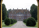
|
Nysø
|
Vordingborg Kommune
|
55°07′36″N 12°01′50″Ø / 55.12666667°N 12.03055556°Ø / 55.12666667; 12.03055556
|
Nysø (Præstø Sogn)
|

|
Næsbyholm
|
Næstved Kommune
|
55°22′07″N 11°36′06″Ø / 55.3686°N 11.6017°Ø / 55.3686; 11.6017
|
Næsbyholm
|
|
|
Nøbbøllegård
|
Lolland Kommune
|
54°43′10″N 11°28′42″Ø / 54.7194°N 11.4783°Ø / 54.7194; 11.4783
|
|
|
|
Nøjsomhed
|
Lolland Kommune
|
54°55′56″N 11°05′22″Ø / 54.9323°N 11.08935°Ø / 54.9323; 11.08935
|
|
|
|
Nørager
|
Kalundborg Kommune
|
55°34′36″N 11°21′15″Ø / 55.5768°N 11.3542°Ø / 55.5768; 11.3542
|
|

|
Nøragergård
|
Rebild Kommune
|
56°42′13″N 9°37′54″Ø / 56.7036°N 9.63167°Ø / 56.7036; 9.63167
|
|

|
Nørholm Gods
|
Varde Kommune
|
55°41′09″N 8°36′01″Ø / 55.6857°N 8.60015°Ø / 55.6857; 8.60015
|
|

|
Nørlund Slot
|
Rebild Kommune
|
56°46′56″N 9°43′26″Ø / 56.7822°N 9.7239°Ø / 56.7822; 9.7239
|
Nørlund Slot
|
|
|
Nørre Ravnstrup
|
Brønderslev Kommune
|
57°10′59″N 10°06′37″Ø / 57.18296111°N 10.11030278°Ø / 57.18296111; 10.11030278
|
|
|
|
Nørre Rottrup
|
Aalborg Kommune
|
57°05′30″N 10°14′52″Ø / 57.0917°N 10.2478°Ø / 57.0917; 10.2478
|
|

|
Nørre Vosborg
|
Holstebro Kommune
|
56°19′36″N 8°19′45″Ø / 56.32668°N 8.32908°Ø / 56.32668; 8.32908
|
Nørre Vosborg
|
|
|
Nørre-Elkjær
|
Hjørring Kommune
|
57°34′21″N 10°13′06″Ø / 57.57261°N 10.21846°Ø / 57.57261; 10.21846
|
|

|
Nørregård
|
Guldborgsund Kommune
|
54°46′14″N 11°36′37″Ø / 54.770555555556°N 11.610277777778°Ø / 54.770555555556; 11.610277777778
|
|
|
|
Nørreris
|
Viborg Kommune
|
56°34′44″N 9°18′39″Ø / 56.5789°N 9.31083°Ø / 56.5789; 9.31083
|
|
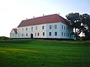
|
Odden Hovedgård
|
Hjørring Kommune
|
57°32′16″N 10°05′39″Ø / 57.53778°N 10.09404°Ø / 57.53778; 10.09404
|
Odden Hovedgård
|
|
|
Orebjerg
|
Frederikssund Kommune
|
55°49′01″N 11°57′40″Ø / 55.8169°N 11.961°Ø / 55.8169; 11.961
|
|

|
Orebygård
|
Guldborgsund Kommune
|
54°49′46″N 11°35′48″Ø / 54.8294°N 11.5968°Ø / 54.8294; 11.5968
|
Orebygård
|

|
Oregård
|
Nordfyns Kommune
|
55°30′27″N 10°01′32″Ø / 55.5075°N 10.0256°Ø / 55.5075; 10.0256
|
|
|
|
Oregård
|
Vordingborg Kommune
|
55°01′44″N 11°50′38″Ø / 55.0288°N 11.844°Ø / 55.0288; 11.844
|
|

|
Orelund
|
Assens Kommune
|
55°20′26″N 9°54′33″Ø / 55.3406°N 9.90917°Ø / 55.3406; 9.90917
|
|

|
Oremandsgård
|
Vordingborg Kommune
|
55°04′10″N 12°03′53″Ø / 55.0694°N 12.0648°Ø / 55.0694; 12.0648
|
Oremandsgaard
|
|
|
Orenæs
|
Guldborgsund Kommune
|
54°57′40″N 11°50′08″Ø / 54.9611°N 11.8356°Ø / 54.9611; 11.8356
|
|
|
|
Ormholt
|
Frederikshavn Kommune
|
57°19′22″N 10°16′15″Ø / 57.3228°N 10.2708°Ø / 57.3228; 10.2708
|
|

|
Ormstrup
|
Viborg Kommune
|
56°19′38″N 9°38′45″Ø / 56.3272°N 9.64583°Ø / 56.3272; 9.64583
|
|

|
Orupgård
|
Guldborgsund Kommune
|
54°45′34″N 11°57′08″Ø / 54.7595°N 11.9523°Ø / 54.7595; 11.9523
|
Orupgaard
|
|
|
Ottestrup
|
Ringsted Kommune
|
55°23′34″N 11°54′32″Ø / 55.3928°N 11.9089°Ø / 55.3928; 11.9089
|
|
|
|
Ouegård
|
Mariagerfjord Kommune
|
56°41′23″N 9°59′42″Ø / 56.6897°N 9.995°Ø / 56.6897; 9.995
|
|
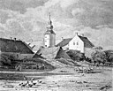
|
Overgård
|
Randers Kommune
|
56°41′02″N 10°14′58″Ø / 56.6839°N 10.2495°Ø / 56.6839; 10.2495
|
Overgård (Randers)
|
|
|
Overklit
|
Hjørring Kommune
|
57°26′25″N 9°51′26″Ø / 57.4403°N 9.85722°Ø / 57.4403; 9.85722
|
|

|
Oxholm
|
Jammerbugt Kommune
|
57°03′46″N 9°34′24″Ø / 57.0628°N 9.57333°Ø / 57.0628; 9.57333
|
Oxholm
|

|
Pagterold
|
Frederikssund Kommune
|
55°46′15″N 11°58′43″Ø / 55.7709°N 11.9785°Ø / 55.7709; 11.9785
|
|
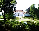
|
Palsgård
|
Hedensted Kommune
|
55°44′48″N 10°01′26″Ø / 55.74656°N 10.02375°Ø / 55.74656; 10.02375
|
Palsgård
|

|
Palstrup
|
Viborg Kommune
|
56°19′18″N 9°30′58″Ø / 56.3216°N 9.51612°Ø / 56.3216; 9.51612
|
|

|
Pandebjerg
|
Guldborgsund Kommune
|
54°48′07″N 11°48′39″Ø / 54.8019°N 11.8108°Ø / 54.8019; 11.8108
|
|
|
|
Pandum
|
Aalborg Kommune
|
56°55′50″N 9°39′46″Ø / 56.9306°N 9.66278°Ø / 56.9306; 9.66278
|
|

|
Pedersholm
|
Vejle Kommune
|
55°41′47″N 9°30′57″Ø / 55.6964°N 9.51583°Ø / 55.6964; 9.51583
|
|

|
Pejrupgård
|
Assens Kommune
|
55°21′27″N 10°08′02″Ø / 55.3575°N 10.1339°Ø / 55.3575; 10.1339
|
Pejrupgård
|

|
Petersgård
|
Vordingborg Kommune
|
55°00′11″N 12°06′12″Ø / 55.003°N 12.1032°Ø / 55.003; 12.1032
|
|
|
|
Philipsdal
|
Kalundborg Kommune
|
55°34′08″N 11°11′39″Ø / 55.56883333°N 11.19422222°Ø / 55.56883333; 11.19422222
|
|
|
|
Porsgaard
|
Rebild Kommune
|
56°46′45″N 10°08′09″Ø / 56.7792°N 10.1358°Ø / 56.7792; 10.1358
|
|

|
Postgården
|
Aalborg Kommune
|
57°00′46″N 9°59′50″Ø / 57.01264°N 9.99718°Ø / 57.01264; 9.99718
|
Postgården (Aalborg)
|
|
|
Poulholm
|
Vesthimmerlands Kommune
|
56°51′09″N 9°31′46″Ø / 56.8525°N 9.52944°Ø / 56.8525; 9.52944
|
|
|
|
Priorskov
|
Guldborgsund Kommune
|
54°44′01″N 11°50′33″Ø / 54.7336°N 11.8425°Ø / 54.7336; 11.8425
|
|

|
Rammegård
|
Lemvig Kommune
|
56°28′58″N 8°11′38″Ø / 56.4827°N 8.1939°Ø / 56.4827; 8.1939
|
Rammegård
|
|
|
Randrup
|
Viborg Kommune
|
56°25′01″N 9°28′09″Ø / 56.4169°N 9.46917°Ø / 56.4169; 9.46917
|
|
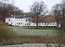
|
Randrup
|
Rebild Kommune
|
56°52′04″N 10°06′44″Ø / 56.8678°N 10.1122°Ø / 56.8678; 10.1122
|
|
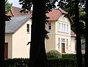
|
Rantzausgave
|
Aarhus Kommune
|
56°00′40″N 10°05′00″Ø / 56.0112°N 10.0834°Ø / 56.0112; 10.0834
|
Rantzausgave
|

|
Rask Hovedgård
|
Hedensted Kommune
|
55°52′56″N 9°35′50″Ø / 55.8822°N 9.59711°Ø / 55.8822; 9.59711
|
|
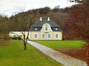
|
Rathlousdal
|
Odder Kommune
|
55°57′53″N 10°07′30″Ø / 55.9647°N 10.125°Ø / 55.9647; 10.125
|
Rathlousdal
|
|
|
Ravnborg
|
Rebild Kommune
|
56°47′57″N 10°10′34″Ø / 56.7992°N 10.1761°Ø / 56.7992; 10.1761
|
|

|
Ravnholt
|
Nyborg Kommune
|
55°15′39″N 10°34′54″Ø / 55.2608°N 10.5817°Ø / 55.2608; 10.5817
|
Ravnholt
|
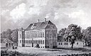
|
Ravnstrup
|
Næstved Kommune
|
55°19′27″N 11°43′43″Ø / 55.3241°N 11.7287°Ø / 55.3241; 11.7287
|
Ravnstrup (Næstved Kommune)
|
|
|
Refsnæs
|
Aalborg Kommune
|
56°54′34″N 10°05′28″Ø / 56.9094°N 10.0911°Ø / 56.9094; 10.0911
|
|

|
Riber Kjærgård
|
Esbjerg Kommune
|
55°25′18″N 8°42′46″Ø / 55.4218°N 8.7127°Ø / 55.4218; 8.7127
|
Riber Kjærgård
|
|
|
Rindumgård
|
Ringkøbing-Skjern Kommune
|
56°06′03″N 8°15′11″Ø / 56.1007°N 8.253°Ø / 56.1007; 8.253
|
|
|
|
Ringstedgård
|
Faaborg-Midtfyn Kommune
|
55°17′42″N 10°28′59″Ø / 55.295°N 10.4831°Ø / 55.295; 10.4831
|
|
|
|
Risbyholm
|
Roskilde Kommune
|
55°32′48″N 12°05′49″Ø / 55.5468°N 12.097°Ø / 55.5468; 12.097
|
|
|
|
Risbølgård
|
Billund Kommune
|
55°38′29″N 8°56′33″Ø / 55.64131388888889°N 8.942394444444444°Ø / 55.64131388888889; 8.942394444444444
|
|

|
Risinge
|
Nyborg Kommune
|
55°24′38″N 10°42′46″Ø / 55.4106°N 10.7128°Ø / 55.4106; 10.7128
|
|

|
Ristrup
|
Aarhus Kommune
|
56°13′22″N 10°03′11″Ø / 56.2228°N 10.0531°Ø / 56.2228; 10.0531
|
|

|
Rodsteenseje
|
Odder Kommune
|
55°57′36″N 10°09′45″Ø / 55.96°N 10.1625°Ø / 55.96; 10.1625
|
|
|
|
Rodvigsballe
|
Horsens Kommune
|
55°59′16″N 9°34′37″Ø / 55.9878°N 9.57699°Ø / 55.9878; 9.57699
|
|

|
Rolsøgaard
|
Syddjurs Kommune
|
56°13′51″N 10°27′27″Ø / 56.2309°N 10.4574°Ø / 56.2309; 10.4574
|
Rolsøgaard
|
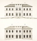
|
Rosendal
|
Faxe Kommune
|
55°13′29″N 12°06′39″Ø / 55.2247°N 12.1109°Ø / 55.2247; 12.1109
|
Rosendal Gods
|
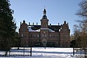
|
Rosenfeldt
|
Vordingborg Kommune
|
55°01′00″N 11°52′34″Ø / 55.0168°N 11.8762°Ø / 55.0168; 11.8762
|
Rosenfeldt
|
|
|
Rosengård
|
Ringsted Kommune
|
55°27′41″N 11°52′44″Ø / 55.4614°N 11.8789°Ø / 55.4614; 11.8789
|
|

|
Rosenlund
|
Guldborgsund Kommune
|
54°44′44″N 11°43′19″Ø / 54.7456°N 11.722°Ø / 54.7456; 11.722
|
|

|
Rosenvold
|
Hedensted Kommune
|
55°40′19″N 9°49′24″Ø / 55.6719°N 9.8234°Ø / 55.6719; 9.8234
|
Rosenvold
|
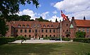
|
Roskilde Kloster
|
Roskilde Kommune
|
55°38′31″N 12°05′11″Ø / 55.642°N 12.0865°Ø / 55.642; 12.0865
|
Roskilde Kloster
|
|
|
Rosvang
|
Thisted Kommune
|
56°56′55″N 8°32′28″Ø / 56.9486°N 8.54111°Ø / 56.9486; 8.54111
|
|

|
Rudbjerggård
|
Lolland Kommune
|
54°46′01″N 11°07′35″Ø / 54.766944444444°N 11.126388888889°Ø / 54.766944444444; 11.126388888889
|
Rudbjerggaard
|
|
|
Rugballegård
|
Vejle Kommune
|
55°43′59″N 9°27′51″Ø / 55.733°N 9.4641°Ø / 55.733; 9.4641
|
|

|
Rugård
|
Nordfyns Kommune
|
55°26′41″N 10°07′21″Ø / 55.4447°N 10.1225°Ø / 55.4447; 10.1225
|
Rugård (Veflinge Sogn)
|

|
Rugård
|
Syddjurs Kommune
|
56°17′05″N 10°48′22″Ø / 56.284819095237°N 10.806043444723°Ø / 56.284819095237; 10.806043444723
|
Rugård Slot
|
|
|
Rumohrsgaard
|
Sønderborg Kommune
|
54°58′37″N 9°54′27″Ø / 54.977°N 9.90755°Ø / 54.977; 9.90755
|
|

|
Rydhave
|
Holstebro Kommune
|
56°27′11″N 8°45′40″Ø / 56.45305°N 8.76124°Ø / 56.45305; 8.76124
|
Rydhave
|
|
|
Ryegård
|
Lejre Kommune
|
55°40′18″N 11°51′54″Ø / 55.6717°N 11.8649°Ø / 55.6717; 11.8649
|
|

|
Rygård
|
Nyborg Kommune
|
55°11′33″N 10°41′59″Ø / 55.1925°N 10.6997°Ø / 55.1925; 10.6997
|
Rygaard (Nyborg Kommune)
|
|
|
Rynkebygård
|
Faaborg-Midtfyn Kommune
|
55°15′17″N 10°27′10″Ø / 55.2547°N 10.4528°Ø / 55.2547; 10.4528
|
|
|
|
Rysensteen
|
Lemvig Kommune
|
56°27′11″N 8°10′42″Ø / 56.4531°N 8.17833°Ø / 56.4531; 8.17833
|
|
|
|
Rådegård
|
Næstved Kommune
|
55°12′49″N 11°56′43″Ø / 55.2135°N 11.9452°Ø / 55.2135; 11.9452
|
|
|
|
Rævkærgård
|
Jammerbugt Kommune
|
57°10′13″N 9°42′37″Ø / 57.1702°N 9.7104°Ø / 57.1702; 9.7104
|
|
|
|
Rødehus
|
Faxe Kommune
|
55°20′05″N 12°03′59″Ø / 55.3346°N 12.0663°Ø / 55.3346; 12.0663
|
|

|
Rødkilde
|
Svendborg Kommune
|
55°04′18″N 10°23′42″Ø / 55.0717°N 10.395°Ø / 55.0717; 10.395
|
Rødkilde Gods
|
|
|
Rødslet
|
Aalborg Kommune
|
57°05′05″N 9°51′00″Ø / 57.084722222222226°N 9.85°Ø / 57.084722222222226; 9.85
|
|

|
Rønhave
|
Sønderborg Kommune
|
54°57′08″N 9°46′12″Ø / 54.95223°N 9.76992°Ø / 54.95223; 9.76992
|
|

|
Rønnebæksholm
|
Næstved Kommune
|
55°13′14″N 11°47′39″Ø / 55.22055556°N 11.79416667°Ø / 55.22055556; 11.79416667
|
Rønnebæksholm
|

|
Rønninge Søgård
|
Kerteminde Kommune
|
55°20′16″N 10°37′51″Ø / 55.3378°N 10.6307°Ø / 55.3378; 10.6307
|
Rønninge Søgård
|
|
|
Rønnovsholm
|
Hjørring Kommune
|
57°23′52″N 10°01′13″Ø / 57.3978°N 10.0203°Ø / 57.3978; 10.0203
|
|

|
Rørbæk
|
Nyborg Kommune
|
55°24′17″N 10°40′13″Ø / 55.4047°N 10.6703°Ø / 55.4047; 10.6703
|
|

|
Salling Østergård
|
Skive Kommune
|
56°45′48″N 8°59′18″Ø / 56.7633°N 8.98833°Ø / 56.7633; 8.98833
|
|
|
|
Saltofte
|
Kalundborg Kommune
|
55°38′05″N 11°16′50″Ø / 55.6347°N 11.2806°Ø / 55.6347; 11.2806
|
|
|
|
Saltø
|
Næstved Kommune
|
55°13′38″N 11°37′56″Ø / 55.2271°N 11.6321°Ø / 55.2271; 11.6321
|
|

|
Sandagergård
|
Nordfyns Kommune
|
55°33′19″N 10°10′08″Ø / 55.55523°N 10.1689°Ø / 55.55523; 10.1689
|
Sandagergård
|

|
Sandbjerg Gods
|
Sønderborg Kommune
|
54°56′59″N 9°45′00″Ø / 54.949696°N 9.750023°Ø / 54.949696; 9.750023
|
Sandbjerg Gods
|
|
|
Sandbygård
|
Næstved Kommune
|
55°22′39″N 11°44′15″Ø / 55.3774°N 11.7375°Ø / 55.3774; 11.7375
|
|

|
Sanderumgård
|
Odense Kommune
|
55°21′11″N 10°31′57″Ø / 55.353°N 10.5326°Ø / 55.353; 10.5326
|
Sanderumgård
|
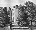
|
Sandholt
|
Faaborg-Midtfyn Kommune
|
55°11′34″N 10°16′36″Ø / 55.1928°N 10.2767°Ø / 55.1928; 10.2767
|
|

|
Schackenborg Slot
|
Tønder Kommune
|
54°56′34″N 8°48′32″Ø / 54.942722222222°N 8.8088027777778°Ø / 54.942722222222; 8.8088027777778
|
Schackenborg Slot
|
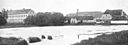
|
Scheelenborg
|
Kerteminde Kommune
|
55°32′07″N 10°38′49″Ø / 55.5353°N 10.6469°Ø / 55.5353; 10.6469
|
Scheelenborg
|
|
|
Scheelsminde
|
Aalborg Kommune
|
57°01′12″N 9°54′12″Ø / 57.02°N 9.90333°Ø / 57.02; 9.90333
|
|
|
|
Schildenseje
|
Favrskov Kommune
|
56°22′49″N 10°12′43″Ø / 56.38016944°N 10.21185°Ø / 56.38016944; 10.21185
|
|
|
|
Sebber Kloster
|
Aalborg Kommune
|
56°57′45″N 9°32′16″Ø / 56.9624°N 9.5377°Ø / 56.9624; 9.5377
|
|
|
|
Sejlgård
|
Silkeborg Kommune
|
56°08′29″N 9°27′20″Ø / 56.1414°N 9.45556°Ø / 56.1414; 9.45556
|
|
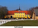
|
Sejlstrupgård
|
Hjørring Kommune
|
57°24′56″N 9°53′28″Ø / 57.4156°N 9.89111°Ø / 57.4156; 9.89111
|
Sejlstrupgård
|

|
Selchausdal
|
Kalundborg Kommune
|
55°35′03″N 11°19′37″Ø / 55.5841°N 11.327°Ø / 55.5841; 11.327
|
Selchausdal
|
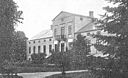
|
Sellebjerg
|
Kerteminde Kommune
|
55°23′32″N 10°32′39″Ø / 55.3922°N 10.5442°Ø / 55.3922; 10.5442
|
|

|
Selsø
|
Frederikssund Kommune
|
55°44′28″N 12°00′37″Ø / 55.7411°N 12.0104°Ø / 55.7411; 12.0104
|
Selsø Slot
|
|
|
Serridslevgård
|
Horsens Kommune
|
55°54′06″N 9°55′23″Ø / 55.9016°N 9.92292°Ø / 55.9016; 9.92292
|
|
|
|
Sevedø
|
Slagelse Kommune
|
55°11′45″N 11°18′34″Ø / 55.195833333333°N 11.309444444444°Ø / 55.195833333333; 11.309444444444
|
|
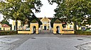
|
Silkeborg Hovedgård
|
Silkeborg Kommune
|
56°10′08″N 9°33′11″Ø / 56.16901°N 9.55308°Ø / 56.16901; 9.55308
|
Silkeborg Hovedgård
|
|
|
Sindinggård
|
Herning Kommune
|
56°12′31″N 8°51′45″Ø / 56.2086°N 8.8626°Ø / 56.2086; 8.8626
|
|
|
|
Sjørupgård
|
Syddjurs Kommune
|
56°24′18″N 10°36′44″Ø / 56.4049°N 10.6123°Ø / 56.4049; 10.6123
|
|

|
Skaføgård
|
Syddjurs Kommune
|
56°22′08″N 10°24′34″Ø / 56.36893°N 10.40947°Ø / 56.36893; 10.40947
|
Skaføgård
|
|
|
Skeelslund
|
Jammerbugt Kommune
|
57°07′51″N 9°44′34″Ø / 57.1307°N 9.74268°Ø / 57.1307; 9.74268
|
|
|
|
Skerrildgård
|
Hedensted Kommune
|
55°44′31″N 9°52′34″Ø / 55.7419°N 9.87611°Ø / 55.7419; 9.87611
|
|
|
|
Skibstedgaard
|
Thisted Kommune
|
56°41′31″N 8°25′50″Ø / 56.6919°N 8.43056°Ø / 56.6919; 8.43056
|
|
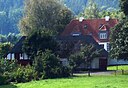
|
Skjern Hovedgård
|
Viborg Kommune
|
56°27′03″N 9°45′04″Ø / 56.4508°N 9.75111°Ø / 56.4508; 9.75111
|
|

|
Skjoldemose
|
Svendborg Kommune
|
55°06′09″N 10°28′34″Ø / 55.1025°N 10.4761°Ø / 55.1025; 10.4761
|
|

|
Skjoldenæsholm
|
Ringsted Kommune
|
55°32′08″N 11°51′11″Ø / 55.53551389°N 11.853°Ø / 55.53551389; 11.853
|
Skjoldenæsholm
|
|
|
Skjørringe
|
Guldborgsund Kommune
|
54°51′03″N 11°57′48″Ø / 54.8508°N 11.9633°Ø / 54.8508; 11.9633
|
|
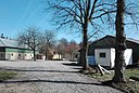
|
Skovbølgård
|
Aabenraa Kommune
|
55°00′19″N 9°33′12″Ø / 55.0054°N 9.5532°Ø / 55.0054; 9.5532
|
Skovbølgård
|

|
Skovgaarde
|
Assens Kommune
|
55°15′19″N 10°01′48″Ø / 55.2553°N 10.03°Ø / 55.2553; 10.03
|
|
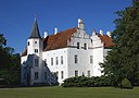
|
Skovsbo
|
Kerteminde Kommune
|
55°23′35″N 10°37′57″Ø / 55.393055555556°N 10.6325°Ø / 55.393055555556; 10.6325
|
Skovsbo (Rynkeby)
|
|
|
Skovsbo
|
Langeland Kommune
|
54°53′43″N 10°46′21″Ø / 54.8953°N 10.7725°Ø / 54.8953; 10.7725
|
|

|
Skovsgård
|
Langeland Kommune
|
54°50′42″N 10°45′04″Ø / 54.84504°N 10.75099°Ø / 54.84504; 10.75099
|
Skovsgård (Langeland)
|
|
|
Skrillingegård
|
Middelfart Kommune
|
55°28′56″N 9°45′21″Ø / 55.4822°N 9.75583°Ø / 55.4822; 9.75583
|
|
|
|
Skrumsager
|
Ringkøbing-Skjern Kommune
|
55°48′11″N 8°18′22″Ø / 55.803°N 8.306°Ø / 55.803; 8.306
|
|

|
Skårupgård
|
Aarhus Kommune
|
56°15′04″N 10°12′53″Ø / 56.2511°N 10.2147°Ø / 56.2511; 10.2147
|
|
|
|
Skårupgård
|
Hjørring Kommune
|
57°27′44″N 10°20′35″Ø / 57.4622°N 10.3431°Ø / 57.4622; 10.3431
|
|

|
Skærsø
|
Syddjurs Kommune
|
56°14′21″N 10°42′34″Ø / 56.23928°N 10.70933°Ø / 56.23928; 10.70933
|
Skærsø (herregård)
|

|
Skærvad
|
Norddjurs Kommune
|
56°26′00″N 10°45′04″Ø / 56.4333°N 10.7511°Ø / 56.4333; 10.7511
|
|
|
|
Slagslunde Hovedgård
|
Egedal Kommune
|
|
|
|
|
Slettegård
|
Jammerbugt Kommune
|
57°08′15″N 9°20′51″Ø / 57.1375°N 9.3475°Ø / 57.1375; 9.3475
|
|
|
|
Slumstrup
|
Ringkøbing-Skjern Kommune
|
56°00′10″N 8°33′37″Ø / 56.0028°N 8.56028°Ø / 56.0028; 8.56028
|
|
|
|
Smakkerupgård
|
Kalundborg Kommune
|
55°40′50″N 11°13′27″Ø / 55.6805°N 11.2243°Ø / 55.6805; 11.2243
|
|

|
Snedinge
|
Slagelse Kommune
|
55°13′29″N 11°25′36″Ø / 55.2246°N 11.4266°Ø / 55.2246; 11.4266
|
Snedinge
|

|
Snertingegård
|
Vordingborg Kommune
|
55°03′51″N 11°55′10″Ø / 55.0642°N 11.9195°Ø / 55.0642; 11.9195
|
Snertingegård
|
|
|
Sofiedal
|
Faxe Kommune
|
55°20′45″N 11°59′24″Ø / 55.3458°N 11.99°Ø / 55.3458; 11.99
|
|
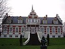
|
Sohngårdsholm
|
Aalborg Kommune
|
57°01′54″N 9°56′40″Ø / 57.0317°N 9.94444°Ø / 57.0317; 9.94444
|
Sohngaardsholm Slot
|
|
|
Solbjerggård
|
Kalundborg Kommune
|
55°28′03″N 11°20′49″Ø / 55.4676°N 11.347°Ø / 55.4676; 11.347
|
|

|
Sonnerupgaard Gods
|
Lejre Kommune
|
55°36′06″N 11°50′13″Ø / 55.6016°N 11.8369°Ø / 55.6016; 11.8369
|
Sonnerupgaard Gods
|

|
Sophiendal
|
Skanderborg Kommune
|
56°06′42″N 9°52′45″Ø / 56.1116°N 9.8793°Ø / 56.1116; 9.8793
|
Sophiendal (Jylland)
|
|
|
Sophiendal
|
Lolland Kommune
|
54°54′52″N 11°10′22″Ø / 54.9144°N 11.1728°Ø / 54.9144; 11.1728
|
|

|
Sophienholm
|
Lyngby-Taarbæk Kommune
|
55°46′31″N 12°27′27″Ø / 55.7754°N 12.4576°Ø / 55.7754; 12.4576
|
Sophienholm
|
|
|
Sorvad
|
Norddjurs Kommune
|
56°28′39″N 10°24′26″Ø / 56.4776°N 10.4072°Ø / 56.4776; 10.4072
|
|
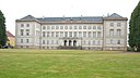
|
Sorø Akademi
|
Sorø Kommune
|
55°25′47″N 11°33′22″Ø / 55.4298°N 11.5561°Ø / 55.4298; 11.5561
|
Sorø Akademi
|

|
Sostrup Slot
|
Norddjurs Kommune
|
56°29′52″N 10°49′27″Ø / 56.4978°N 10.82422°Ø / 56.4978; 10.82422
|
Sostrup Slot
|
|
|
Spanager
|
Køge Kommune
|
55°28′52″N 12°03′23″Ø / 55.481°N 12.0565°Ø / 55.481; 12.0565
|
|

|
Sparresholm
|
Næstved Kommune
|
55°14′12″N 11°57′03″Ø / 55.2367°N 11.9508°Ø / 55.2367; 11.9508
|
Sparresholm
|

|
Steensgård
|
Langeland Kommune
|
55°06′36″N 10°55′02″Ø / 55.10988°N 10.91712°Ø / 55.10988; 10.91712
|
Steensgård
|
|
|
Stenagergård
|
Kerteminde Kommune
|
55°31′14″N 10°35′43″Ø / 55.5206°N 10.5953°Ø / 55.5206; 10.5953
|
|

|
Stenalt
|
Norddjurs Kommune
|
56°30′30″N 10°17′28″Ø / 56.5084°N 10.2911°Ø / 56.5084; 10.2911
|
Stenalt (Djursland)
|

|
Stensballegård
|
Horsens Kommune
|
55°52′19″N 9°55′31″Ø / 55.8719°N 9.9254°Ø / 55.8719; 9.9254
|
Stensballegård
|

|
Stensbygård
|
Vordingborg Kommune
|
54°58′45″N 12°01′40″Ø / 54.9792°N 12.0278°Ø / 54.9792; 12.0278
|
|
|
|
Stensbæk
|
Hjørring Kommune
|
57°33′09″N 10°13′06″Ø / 57.5525°N 10.2184°Ø / 57.5525; 10.2184
|
|
|
|
Stensgård
|
Lolland Kommune
|
54°53′37″N 11°02′07″Ø / 54.8936°N 11.0353°Ø / 54.8936; 11.0353
|
|

|
Stensgård
|
Faaborg-Midtfyn Kommune
|
55°08′27″N 10°10′58″Ø / 55.1407°N 10.1828°Ø / 55.1407; 10.1828
|
Stensgaard (Svanninge Sogn)
|

|
Stensmark
|
Norddjurs Kommune
|
56°26′41″N 10°56′44″Ø / 56.4447°N 10.9456°Ø / 56.4447; 10.9456
|
Stensmark
|
|
|
Stjernholm
|
Horsens Kommune
|
|
|

|
Store Borupgård
|
Horsens Kommune
|
55°56′44″N 9°52′35″Ø / 55.9456°N 9.87639°Ø / 55.9456; 9.87639
|
Store Borupgård
|
|
|
Store Flinterup
|
Kalundborg Kommune
|
55°35′43″N 11°13′48″Ø / 55.5953°N 11.2299°Ø / 55.5953; 11.2299
|
|
|
|
Store Frederikslund
|
Slagelse Kommune
|
55°26′33″N 11°27′47″Ø / 55.4425°N 11.4631°Ø / 55.4425; 11.4631
|
Store Frederikslund
|
|
|
Store Grundet
|
Vejle Kommune
|
55°44′01″N 9°32′50″Ø / 55.7336°N 9.54722°Ø / 55.7336; 9.54722
|
|
|
|
Store Ladegård
|
Sorø Kommune
|
55°26′14″N 11°36′27″Ø / 55.4372°N 11.6075°Ø / 55.4372; 11.6075
|
|
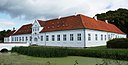
|
Store Restrup Herregård
|
Aalborg Kommune
|
57°00′18″N 9°46′30″Ø / 57.005°N 9.7749°Ø / 57.005; 9.7749
|
Store Restrup
|
|
|
Store Rugtved
|
Frederikshavn Kommune
|
57°12′17″N 10°26′42″Ø / 57.2047°N 10.445°Ø / 57.2047; 10.445
|
|
|
|
Stougård
|
Hedensted Kommune
|
55°50′47″N 9°28′30″Ø / 55.8464°N 9.475°Ø / 55.8464; 9.475
|
|

|
Strandegård
|
Faxe Kommune
|
55°11′13″N 12°06′44″Ø / 55.1869°N 12.1123°Ø / 55.1869; 12.1123
|
Strandegård
|

|
Stranderholm
|
Aalborg Kommune
|
57°01′51″N 10°04′56″Ø / 57.0309°N 10.0823°Ø / 57.0309; 10.0823
|
|

|
Strandet
|
Skive Kommune
|
56°34′25″N 9°14′14″Ø / 56.5737°N 9.2371°Ø / 56.5737; 9.2371
|
Strandet Hovedgaard
|
|
|
Strandholm
|
Lolland Kommune
|
54°39′12″N 11°22′30″Ø / 54.6533°N 11.375°Ø / 54.6533; 11.375
|
|
|
|
Striben
|
Aalborg Kommune
|
57°06′32″N 10°09′14″Ø / 57.1089°N 10.1539°Ø / 57.1089; 10.1539
|
|

|
Stårup Hovedgård
|
Skive Kommune
|
56°35′11″N 9°06′41″Ø / 56.5864°N 9.11139°Ø / 56.5864; 9.11139
|
|
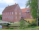
|
Støvringgård
|
Randers Kommune
|
56°30′08″N 10°12′11″Ø / 56.50212°N 10.20301°Ø / 56.50212; 10.20301
|
Støvringgård
|

|
Svanholm Gods
|
Frederikssund Kommune
|
55°47′01″N 11°56′22″Ø / 55.7836°N 11.9394°Ø / 55.7836; 11.9394
|
Svanholm Gods
|

|
Svenstrup
|
Køge Kommune
|
55°29′30″N 11°57′19″Ø / 55.4918°N 11.9552°Ø / 55.4918; 11.9552
|
|
|
|
Svinningegård
|
Holbæk Kommune
|
55°43′24″N 11°29′03″Ø / 55.7233°N 11.4842°Ø / 55.7233; 11.4842
|
|
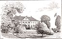
|
Sæbygård
|
Kalundborg Kommune
|
55°33′16″N 11°18′52″Ø / 55.5544°N 11.3144°Ø / 55.5544; 11.3144
|
|

|
Sæbygård
|
Frederikshavn Kommune
|
57°20′02″N 10°28′44″Ø / 57.3339°N 10.4789°Ø / 57.3339; 10.4789
|
Sæbygård (Vendsyssel)
|

|
Sæbyholm
|
Lolland Kommune
|
54°50′02″N 11°11′29″Ø / 54.8339°N 11.1914°Ø / 54.8339; 11.1914
|
Sæbyholm
|
|
|
Sædingegård
|
Lolland Kommune
|
54°42′52″N 11°24′21″Ø / 54.7144°N 11.4058°Ø / 54.7144; 11.4058
|
|
|
|
Særslevgård
|
Kalundborg Kommune
|
55°43′46″N 11°23′16″Ø / 55.72947222°N 11.38788889°Ø / 55.72947222; 11.38788889
|
|
|
|
Sø Hovedgård
|
Morsø Kommune
|
56°54′13″N 8°50′51″Ø / 56.9036°N 8.8475°Ø / 56.9036; 8.8475
|
|

|
Søbo
|
Assens Kommune
|
55°12′22″N 10°12′10″Ø / 55.2061°N 10.2028°Ø / 55.2061; 10.2028
|
Søbo (Jordløse Sogn)
|

|
Søbygaard
|
Favrskov Kommune
|
56°15′16″N 9°47′45″Ø / 56.2544°N 9.79586°Ø / 56.2544; 9.79586
|
|

|
Søbygård
|
Ærø Kommune
|
54°55′09″N 10°16′56″Ø / 54.91917°N 10.28231°Ø / 54.91917; 10.28231
|
Søbygård
|
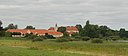
|
Søbysøgård
|
Faaborg-Midtfyn Kommune
|
55°17′28″N 10°22′06″Ø / 55.29103°N 10.36825°Ø / 55.29103; 10.36825
|
Søbysøgård
|
|
|
Sødal
|
Viborg Kommune
|
56°30′50″N 9°30′25″Ø / 56.5139°N 9.50694°Ø / 56.5139; 9.50694
|
|
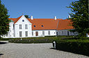
|
Sødringholm
|
Randers Kommune
|
56°37′45″N 10°19′15″Ø / 56.6291°N 10.3209°Ø / 56.6291; 10.3209
|
|
|
|
Søgaard
|
Langeland Kommune
|
54°44′09″N 10°40′55″Ø / 54.7358°N 10.6819°Ø / 54.7358; 10.6819
|
|

|
Søholm
|
Assens Kommune
|
55°16′44″N 10°07′42″Ø / 55.2789°N 10.1283°Ø / 55.2789; 10.1283
|
|
|
|
Søholm
|
Stevns Kommune
|
55°22′14″N 12°22′14″Ø / 55.3706°N 12.3706°Ø / 55.3706; 12.3706
|
|

|
Søholt
|
Lolland Kommune
|
54°44′28″N 11°32′20″Ø / 54.7411°N 11.5389°Ø / 54.7411; 11.5389
|
Søholt
|

|
Søllestedgård
|
Lolland Kommune
|
54°49′16″N 11°17′06″Ø / 54.8211°N 11.285°Ø / 54.8211; 11.285
|
|
|
|
Sønder Elkær
|
Aalborg Kommune
|
57°09′53″N 9°56′15″Ø / 57.1647°N 9.9375°Ø / 57.1647; 9.9375
|
|
|
|
Søndergårde
|
Assens Kommune
|
55°23′50″N 10°01′54″Ø / 55.3972°N 10.0317°Ø / 55.3972; 10.0317
|
|
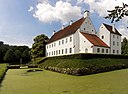
|
Sønderskov Hovedgård
|
Vejen Kommune
|
55°27′06″N 9°02′16″Ø / 55.45176°N 9.03773°Ø / 55.45176; 9.03773
|
Sønderskov Hovedgård
|

|
Sørup
|
Ringsted Kommune
|
55°23′10″N 11°47′40″Ø / 55.3861°N 11.7945°Ø / 55.3861; 11.7945
|
Sørup Herregård
|
|
|
Søvig
|
Varde Kommune
|
55°40′26″N 8°20′35″Ø / 55.67388888888889°N 8.343055555555555°Ø / 55.67388888888889; 8.343055555555555
|
|
|
|
Tamdrup Bisgård
|
Horsens Kommune
|
55°53′16″N 9°44′13″Ø / 55.8877°N 9.73703°Ø / 55.8877; 9.73703
|
|
|
|
Tammestrup
|
Skanderborg Kommune
|
55°59′05″N 9°51′26″Ø / 55.9847°N 9.85722°Ø / 55.9847; 9.85722
|
|
|
|
Tandrup
|
Thisted Kommune
|
56°50′36″N 8°25′22″Ø / 56.84321°N 8.4228°Ø / 56.84321; 8.4228
|
|

|
Tersløsegård
|
Sorø Kommune
|
55°30′40″N 11°29′25″Ø / 55.511°N 11.4903°Ø / 55.511; 11.4903
|
Tersløsegaard
|
|
|
Thomasminde
|
Aarhus Kommune
|
56°16′17″N 10°09′12″Ø / 56.2715°N 10.1533°Ø / 56.2715; 10.1533
|
|
|
|
Thygeslund
|
Mariagerfjord Kommune
|
56°42′07″N 10°05′50″Ø / 56.70193°N 10.09731°Ø / 56.70193; 10.09731
|
|
|
|
Tidemandsholm
|
Hjørring Kommune
|
57°22′53″N 10°11′24″Ø / 57.3814°N 10.19°Ø / 57.3814; 10.19
|
|
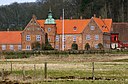
|
Tirsbæk
|
Vejle Kommune
|
55°42′48″N 9°38′15″Ø / 55.71324°N 9.6375°Ø / 55.71324; 9.6375
|
Tirsbæk
|
|
|
Tiselholt
|
Svendborg Kommune
|
55°05′54″N 10°45′09″Ø / 55.0983°N 10.7525°Ø / 55.0983; 10.7525
|
|

|
Tjele Gods
|
Viborg Kommune
|
56°30′38″N 9°36′41″Ø / 56.5106°N 9.61139°Ø / 56.5106; 9.61139
|
Tjele Gods
|
|
|
Toftholm
|
Holbæk Kommune
|
55°40′15″N 11°30′53″Ø / 55.6708°N 11.5147°Ø / 55.6708; 11.5147
|
|

|
Torbenfeldt
|
Holbæk Kommune
|
55°38′19″N 11°31′04″Ø / 55.638611111111°N 11.517777777778°Ø / 55.638611111111; 11.517777777778
|
Torbenfeldt Slot
|
|
|
Torpegård
|
Frederikssund Kommune
|
55°46′48″N 12°02′28″Ø / 55.7801°N 12.0412°Ø / 55.7801; 12.0412
|
|

|
Torpegård
|
Faaborg-Midtfyn Kommune
|
55°18′47″N 10°31′10″Ø / 55.3131°N 10.5194°Ø / 55.3131; 10.5194
|
|
|
|
Torstedlund
|
Rebild Kommune
|
56°48′22″N 9°43′33″Ø / 56.8061°N 9.72583°Ø / 56.8061; 9.72583
|
|

|
Tranekær Slot
|
Langeland Kommune
|
55°00′06″N 10°51′21″Ø / 55.00176°N 10.85586°Ø / 55.00176; 10.85586
|
Tranekær Slot
|
|
|
Trollesminde
|
Hillerød Kommune
|
55°55′16″N 12°17′05″Ø / 55.92105°N 12.28463°Ø / 55.92105; 12.28463
|
|

|
Trudsholm
|
Lejre Kommune
|
55°38′47″N 11°50′38″Ø / 55.6464°N 11.8438°Ø / 55.6464; 11.8438
|
|

|
Trudsholm
|
Randers Kommune
|
56°39′11″N 10°10′20″Ø / 56.65314°N 10.17222°Ø / 56.65314; 10.17222
|
Trudsholm
|
|
|
Tryggevælde
|
Faxe Kommune
|
55°20′05″N 12°13′54″Ø / 55.3347°N 12.2316°Ø / 55.3347; 12.2316
|
|
|
|
Tulsted
|
Rebild Kommune
|
56°50′04″N 9°56′26″Ø / 56.8344°N 9.94056°Ø / 56.8344; 9.94056
|
|
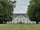
|
Turebyholm
|
Faxe Kommune
|
55°20′50″N 12°05′34″Ø / 55.3471°N 12.0929°Ø / 55.3471; 12.0929
|
Turebyholm
|
|
|
Turebylille
|
Faxe Kommune
|
55°21′54″N 12°05′27″Ø / 55.3649°N 12.0908°Ø / 55.3649; 12.0908
|
|
|
|
Tustrup
|
Randers Kommune
|
56°23′50″N 10°11′23″Ø / 56.3972°N 10.1897°Ø / 56.3972; 10.1897
|
|
|
|
Tustrup
|
Rebild Kommune
|
56°52′01″N 9°57′35″Ø / 56.8669°N 9.95972°Ø / 56.8669; 9.95972
|
|
|
|
Tvilumgård
|
Silkeborg Kommune
|
56°15′19″N 9°40′49″Ø / 56.2554°N 9.68033°Ø / 56.2554; 9.68033
|
|

|
Tybjerggård
|
Næstved Kommune
|
55°20′54″N 11°48′27″Ø / 55.3483°N 11.8075°Ø / 55.3483; 11.8075
|
Tybjerggaard
|
|
|
Tybrind
|
Middelfart Kommune
|
55°23′59″N 9°51′56″Ø / 55.3997°N 9.86556°Ø / 55.3997; 9.86556
|
|

|
Tyrrestrup
|
Horsens Kommune
|
55°53′47″N 9°58′05″Ø / 55.8964°N 9.9681°Ø / 55.8964; 9.9681
|
Tyrrestrup
|

|
Tårnborg
|
Slagelse Kommune
|
55°20′45″N 11°08′34″Ø / 55.3459°N 11.1427°Ø / 55.3459; 11.1427
|
Tårnborg (Korsør)
|

|
Tårnholm
|
Slagelse Kommune
|
55°20′36″N 11°12′51″Ø / 55.3434°N 11.2141°Ø / 55.3434; 11.2141
|
Tårnholm
|

|
Tårupgård
|
Viborg Kommune
|
56°32′25″N 9°16′38″Ø / 56.5402°N 9.2772°Ø / 56.5402; 9.2772
|
Tårupgård
|
|
|
Tøjstrup
|
Faaborg-Midtfyn Kommune
|
55°15′06″N 10°31′16″Ø / 55.2517°N 10.5211°Ø / 55.2517; 10.5211
|
|

|
Tølløse Slot
|
Holbæk Kommune
|
55°36′42″N 11°44′42″Ø / 55.6118°N 11.7449°Ø / 55.6118; 11.7449
|
Tølløse Slot
|
|
|
Uggerslevgård
|
Nordfyns Kommune
|
55°32′03″N 10°18′15″Ø / 55.5342°N 10.3042°Ø / 55.5342; 10.3042
|
|

|
Ulriksdal
|
Guldborgsund Kommune
|
54°43′17″N 11°35′36″Ø / 54.7214°N 11.5934°Ø / 54.7214; 11.5934
|
Godsted
|
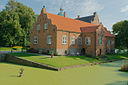
|
Ulriksholm
|
Kerteminde Kommune
|
55°25′22″N 10°34′10″Ø / 55.4229°N 10.5695°Ø / 55.4229; 10.5695
|
Ulriksholm (Fyn)
|
|
|
Ulstrup
|
Thisted Kommune
|
56°54′28″N 8°29′55″Ø / 56.9078°N 8.49861°Ø / 56.9078; 8.49861
|
|

|
Ulstrup Slot
|
Favrskov Kommune
|
56°23′46″N 9°47′26″Ø / 56.3962°N 9.7905°Ø / 56.3962; 9.7905
|
Ulstrup Slot
|

|
Urup
|
Horsens Kommune
|
55°56′53″N 9°46′34″Ø / 55.9481°N 9.77611°Ø / 55.9481; 9.77611
|
|
|
|
Ussinggård
|
Hedensted Kommune
|
55°50′04″N 9°42′35″Ø / 55.8344°N 9.70972°Ø / 55.8344; 9.70972
|
|
|
|
Vadskærgård
|
Lemvig Kommune
|
56°34′49″N 8°14′54″Ø / 56.5802°N 8.2484°Ø / 56.5802; 8.2484
|
|

|
Valbygård
|
Slagelse Kommune
|
55°25′34″N 11°18′21″Ø / 55.426°N 11.3057°Ø / 55.426; 11.3057
|
Valbygård
|

|
Valdemars Slot
|
Svendborg Kommune
|
55°01′20″N 10°39′11″Ø / 55.02236°N 10.65316°Ø / 55.02236; 10.65316
|
Valdemars Slot
|

|
Valnæsgård
|
Guldborgsund Kommune
|
54°56′13″N 11°44′37″Ø / 54.9369°N 11.7436°Ø / 54.9369; 11.7436
|
|
|
|
Vang Hovedgård
|
Aalborg Kommune
|
57°08′31″N 9°56′09″Ø / 57.142°N 9.9358°Ø / 57.142; 9.9358
|
|

|
Vedbygård
|
Sorø Kommune
|
55°32′39″N 11°22′29″Ø / 55.5441°N 11.3748°Ø / 55.5441; 11.3748
|
Vedbygaard
|

|
Vedø Hovedgård
|
Syddjurs Kommune
|
56°22′46″N 10°35′50″Ø / 56.3794°N 10.5973°Ø / 56.3794; 10.5973
|
Vedø Hovedgård
|
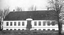
|
Vejlegård
|
Faaborg-Midtfyn Kommune
|
55°16′45″N 10°18′12″Ø / 55.2793°N 10.3034°Ø / 55.2793; 10.3034
|
Vejlegård
|

|
Vejrupgård
|
Kerteminde Kommune
|
55°22′31″N 10°31′16″Ø / 55.3753°N 10.5211°Ø / 55.3753; 10.5211
|
Vejrupgård
|
|
|
Vejstrupgård
|
Svendborg Kommune
|
55°06′11″N 10°42′21″Ø / 55.1031°N 10.7058°Ø / 55.1031; 10.7058
|
|

|
Vemmetofte
|
Faxe Kommune
|
55°15′19″N 12°13′33″Ø / 55.2553°N 12.2259°Ø / 55.2553; 12.2259
|
Vemmetofte Kloster
|

|
Vennerslund
|
Guldborgsund Kommune
|
54°51′22″N 11°48′06″Ø / 54.8561°N 11.8017°Ø / 54.8561; 11.8017
|
Vennerslund
|
|
|
Vester Kejlstrup
|
Silkeborg Kommune
|
56°11′27″N 9°33′33″Ø / 56.1908°N 9.55917°Ø / 56.1908; 9.55917
|
|
|
|
Vester Nejsig
|
Aalborg Kommune
|
57°05′53″N 10°11′58″Ø / 57.0981°N 10.1994°Ø / 57.0981; 10.1994
|
|
|
|
Vesterbygård
|
Kalundborg Kommune
|
55°36′37″N 11°16′36″Ø / 55.6102°N 11.2766°Ø / 55.6102; 11.2766
|
|

|
Vestergaard
|
Langeland Kommune
|
54°51′16″N 10°41′56″Ø / 54.8544°N 10.6989°Ø / 54.8544; 10.6989
|
|

|
Vestervig Kloster
|
Thisted Kommune
|
56°46′24″N 8°19′02″Ø / 56.7732°N 8.31722°Ø / 56.7732; 8.31722
|
|
|
|
Vibygård
|
Roskilde Kommune
|
55°33′47″N 12°01′24″Ø / 55.5631°N 12.0233°Ø / 55.5631; 12.0233
|
|
|
|
Vildmosegaard
|
Aalborg Kommune
|
56°53′17″N 10°13′16″Ø / 56.8881°N 10.2211°Ø / 56.8881; 10.2211
|
|

|
Vilhelmsborg
|
Aarhus Kommune
|
56°04′06″N 10°11′21″Ø / 56.06837°N 10.18903°Ø / 56.06837; 10.18903
|
Vilhelmsborg
|
|
|
Vilhelmsborg
|
Assens Kommune
|
55°17′46″N 9°56′40″Ø / 55.2961°N 9.94444°Ø / 55.2961; 9.94444
|
|
|
|
Villerup
|
Hjørring Kommune
|
57°27′30″N 9°52′09″Ø / 57.4583°N 9.86917°Ø / 57.4583; 9.86917
|
|

|
Vinderslevholm
|
Silkeborg Kommune
|
56°15′14″N 9°29′00″Ø / 56.2538°N 9.4834°Ø / 56.2538; 9.4834
|
|

|
Vinderupgård
|
Holstebro Kommune
|
56°29′07″N 8°46′38″Ø / 56.48527°N 8.7772°Ø / 56.48527; 8.7772
|
|
|
|
Vindum Overgård
|
Viborg Kommune
|
56°22′40″N 9°34′24″Ø / 56.3778°N 9.57333°Ø / 56.3778; 9.57333
|
|
|
|
Vingegård Gods
|
Viborg Kommune
|
56°32′08″N 9°40′34″Ø / 56.5356°N 9.67611°Ø / 56.5356; 9.67611
|
|
|
|
Vintersborg
|
Lolland Kommune
|
54°56′07″N 11°11′36″Ø / 54.9353°N 11.1933°Ø / 54.9353; 11.1933
|
|

|
Visborggård
|
Mariagerfjord Kommune
|
56°44′39″N 10°09′07″Ø / 56.7441°N 10.152°Ø / 56.7441; 10.152
|
Visborggård
|

|
Viskum
|
Viborg Kommune
|
56°27′01″N 9°35′12″Ø / 56.4502°N 9.5868°Ø / 56.4502; 9.5868
|
Viskum Hovedgård
|
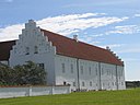
|
Vitskøl Kloster
|
Vesthimmerlands Kommune
|
56°52′08″N 9°12′48″Ø / 56.8688°N 9.2132°Ø / 56.8688; 9.2132
|
Vitskøl Kloster
|
|
|
Vivebrogaard
|
Mariagerfjord Kommune
|
56°41′44″N 10°02′22″Ø / 56.6956°N 10.0394°Ø / 56.6956; 10.0394
|
|

|
Voergaard Slot
|
Brønderslev Kommune
|
57°14′33″N 10°20′07″Ø / 57.2425°N 10.3354°Ø / 57.2425; 10.3354
|
Voergaard Slot
|

|
Vognserup
|
Holbæk Kommune
|
55°42′30″N 11°33′28″Ø / 55.7084°N 11.5579°Ø / 55.7084; 11.5579
|
Vognserup
|
|
|
Volstrup
|
Rebild Kommune
|
56°40′55″N 9°42′33″Ø / 56.6819°N 9.7092°Ø / 56.6819; 9.7092
|
|
|
|
Vorgaard
|
Rebild Kommune
|
56°50′21″N 10°05′27″Ø / 56.8392°N 10.0908°Ø / 56.8392; 10.0908
|
|
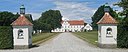
|
Vosnæsgård
|
Aarhus Kommune
|
56°17′01″N 10°21′16″Ø / 56.28362°N 10.35434°Ø / 56.28362; 10.35434
|
Vosnæsgård
|

|
Vrejlev Kloster
|
Hjørring Kommune
|
57°21′41″N 10°00′10″Ø / 57.3615°N 10.0027°Ø / 57.3615; 10.0027
|
Vrejlev Kloster
|
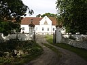
|
Vår
|
Aalborg Kommune
|
57°00′06″N 9°27′08″Ø / 57.00164°N 9.4521°Ø / 57.00164; 9.4521
|
Waar Hovedgård
|
|
|
Vårskovgård
|
Lolland Kommune
|
54°49′28″N 11°27′57″Ø / 54.8244°N 11.4658°Ø / 54.8244; 11.4658
|
|

|
Wedellsborg
|
Middelfart Kommune
|
55°22′02″N 9°49′12″Ø / 55.3673°N 9.8199°Ø / 55.3673; 9.8199
|
Wedellsborg
|
|
|
Wedelslund
|
Skanderborg Kommune
|
56°10′29″N 9°54′58″Ø / 56.1747°N 9.91619°Ø / 56.1747; 9.91619
|
|
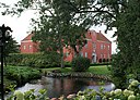
|
Willestrup
|
Mariagerfjord Kommune
|
56°45′51″N 9°57′12″Ø / 56.7641°N 9.9533°Ø / 56.7641; 9.9533
|
Villestrup
|

|
Williamsborg
|
Hedensted Kommune
|
55°44′02″N 9°43′06″Ø / 55.7339°N 9.71833°Ø / 55.7339; 9.71833
|
|
|
|
Zastrov
|
Nordfyns Kommune
|
55°28′06″N 10°16′53″Ø / 55.4683°N 10.2814°Ø / 55.4683; 10.2814
|
|
|
|
Ågård
|
Kalundborg Kommune
|
55°33′32″N 11°12′41″Ø / 55.559°N 11.2113°Ø / 55.559; 11.2113
|
|
|
|
Ågård
|
Jammerbugt Kommune
|
57°04′39″N 9°15′59″Ø / 57.0774°N 9.2665°Ø / 57.0774; 9.2665
|
|
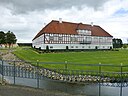
|
Åkær
|
Odder Kommune
|
55°54′39″N 10°06′22″Ø / 55.9107°N 10.1062°Ø / 55.9107; 10.1062
|
Åkær (herregård)
|

|
Åløkkegård
|
Odense Kommune
|
55°24′16″N 10°22′08″Ø / 55.4044°N 10.3688°Ø / 55.4044; 10.3688
|
|
|
|
Ås
|
Hjørring Kommune
|
57°20′34″N 10°05′43″Ø / 57.34265293871303°N 10.09526088349222°Ø / 57.34265293871303; 10.09526088349222
|
|

|
Åstrup
|
Hjørring Kommune
|
57°26′13″N 9°56′03″Ø / 57.4369°N 9.93417°Ø / 57.4369; 9.93417
|
|
|
|
Æbeløgård
|
Nordfyns Kommune
|
55°38′31″N 10°10′08″Ø / 55.6419°N 10.1689°Ø / 55.6419; 10.1689
|
|

|
Øbjerggård
|
Vordingborg Kommune
|
55°06′57″N 11°49′44″Ø / 55.1159°N 11.8288°Ø / 55.1159; 11.8288
|
Øbjerggaard
|
|
|
Ødemark
|
Sorø Kommune
|
55°28′43″N 11°28′43″Ø / 55.4786°N 11.4786°Ø / 55.4786; 11.4786
|
|
|
|
Øland
|
Thisted Kommune
|
56°52′21″N 8°32′24″Ø / 56.8725°N 8.54°Ø / 56.8725; 8.54
|
|
|
|
Øllingsø
|
Lolland Kommune
|
54°47′01″N 11°13′23″Ø / 54.7836°N 11.2231°Ø / 54.7836; 11.2231
|
|

|
Ølstedgård
|
Faaborg-Midtfyn Kommune
|
55°14′48″N 10°18′26″Ø / 55.2467°N 10.3072°Ø / 55.2467; 10.3072
|
|

|
Ørbæklunde
|
Nyborg Kommune
|
55°14′43″N 10°40′09″Ø / 55.2453°N 10.6693°Ø / 55.2453; 10.6693
|
Ørbæklunde
|
|
|
Ørndrup
|
Vesthimmerlands Kommune
|
56°51′06″N 9°22′30″Ø / 56.8517°N 9.375°Ø / 56.8517; 9.375
|
|

|
Ørritslevgård
|
Nordfyns Kommune
|
55°31′27″N 10°25′09″Ø / 55.52408°N 10.41917°Ø / 55.52408; 10.41917
|
Ørritslevgård
|

|
Ørslev Kloster
|
Skive Kommune
|
56°35′51″N 9°13′03″Ø / 56.5976°N 9.21751°Ø / 56.5976; 9.21751
|
Ørslev Kloster
|
|
|
Ørumgård
|
Hedensted Kommune
|
55°44′00″N 9°44′53″Ø / 55.7333°N 9.74806°Ø / 55.7333; 9.74806
|
|
|
|
Østedgaard
|
Fredericia Kommune
|
55°36′08″N 9°41′06″Ø / 55.6022°N 9.685°Ø / 55.6022; 9.685
|
|
|
|
Øster Aslund
|
Aalborg Kommune
|
57°05′20″N 10°09′50″Ø / 57.0889°N 10.1639°Ø / 57.0889; 10.1639
|
|
|
|
Øster Grundet
|
Vejle Kommune
|
55°43′44″N 9°34′00″Ø / 55.728888888889°N 9.5666666666667°Ø / 55.728888888889; 9.5666666666667
|
|
|
|
Øster Kejlstrup
|
Silkeborg Kommune
|
56°11′21″N 9°34′34″Ø / 56.1892°N 9.57611°Ø / 56.1892; 9.57611
|
|
|
|
Øster Nejsig
|
Aalborg Kommune
|
57°05′49″N 10°13′05″Ø / 57.096944444444°N 10.218055555556°Ø / 57.096944444444; 10.218055555556
|
|

|
Østergård
|
Aarhus Kommune
|
56°01′41″N 10°09′21″Ø / 56.0281°N 10.1557°Ø / 56.0281; 10.1557
|
Østergaard
|

|
Østergård
|
Kerteminde Kommune
|
55°25′34″N 10°32′18″Ø / 55.4261°N 10.5383°Ø / 55.4261; 10.5383
|
|
|
|
Østergård
|
Favrskov Kommune
|
56°22′41″N 9°52′52″Ø / 56.378°N 9.88121°Ø / 56.378; 9.88121
|
|
|
|
Østerhovedgård
|
Slagelse Kommune
|
55°12′17″N 11°17′31″Ø / 55.2047°N 11.2919°Ø / 55.2047; 11.2919
|
|

|
Østrupgård
|
Nordfyns Kommune
|
55°29′40″N 10°25′09″Ø / 55.4944°N 10.4191°Ø / 55.4944; 10.4191
|
Østrupgård (Østrup Sogn)
|

|
Østrupgård
|
Faaborg-Midtfyn Kommune
|
55°10′32″N 10°13′48″Ø / 55.1756°N 10.23°Ø / 55.1756; 10.23
|
|
|
|
Østrupgård
|
Roskilde Kommune
|
55°43′34″N 12°11′58″Ø / 55.7261°N 12.1994°Ø / 55.7261; 12.1994
|
|


,_Bild_21.jpg)


.jpg)
.jpg)


_postcard.jpg)


.Hovedbygning.06.707-112730-1.ajb.jpg)


.JPG)


.jpg)


.JPG)


.jpg)


.jpg)


.jpg)


.jpg)


.JPG)


.2.707-112111-1.ajb.jpg)


.png)


.JPG)


_01.jpg)
.jpg)


_-_fra_vest.jpg)

.JPG)


.jpg)


.jpg)


.JPG)


.jpg)

.jpg)
.JPG)
.jpg)


.JPG)


.jpg)


.png)


.jpg)


.jpg)
.jpg)


_20190407-001.jpg)


.webp)


